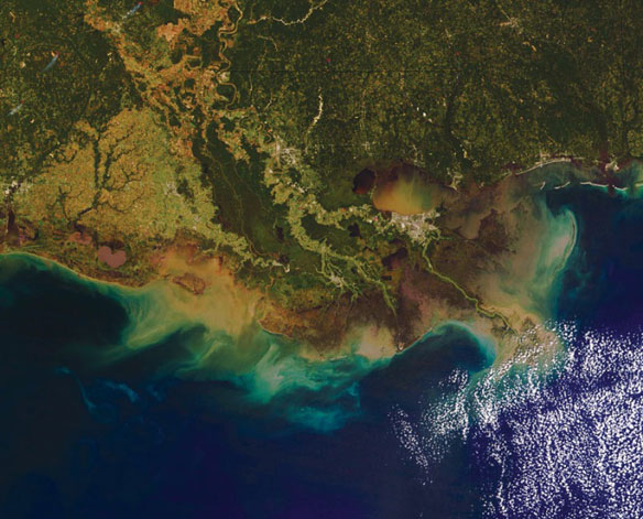

The hypoxic zone in the northern Gulf of Mexico refers to an area along the Louisiana-Texas coast in which water near the bottom of the Gulf contains less than 2 parts per million of dissolved oxygen, causing a condition referred to as hypoxia. Sediment loads from the Mississippi and Atchafalaya Rivers empty into the Gulf of Mexico. Caption USGS. Photo source: NASA
By NOAA
The Gulf of Mexico’s hypoxic zone is predicted to be larger than average this year, due to extreme flooding of the Mississippi River this spring, according to an annual forecast by a team of NOAA-supported scientists from the Louisiana Universities Marine Consortium, Louisiana State University and the University of Michigan. The forecast is based on Mississippi River nutrient inputs compiled annually by the U.S. Geological Survey (USGS).
Scientists are predicting the area could measure between 8,500 and 9,421 square miles, or an area roughly the size of New Hampshire. The largest hypoxic zone measured to date occurred in 2002 and encompassed more than 8,400 square miles.
The average over the past five years is approximately 6,000 square miles of impacted waters, much larger than the 1,900 square miles which is the target goal set by the Gulf of Mexico/Mississippi River Watershed Nutrient Task Force. This collaboration between NOAA, USGS and university scientists facilitates understanding links between activities in the Mississippi River watershed and downstream impacts to the northern Gulf of Mexico.
Hypoxia is caused by excessive nutrient pollution, often from human activities such as agriculture that results in too little oxygen to support most marine life in bottom and near-bottom water.

Hypoxia can cause fish to leave the area and can cause stress or death to bottom dwelling organisms that can’t move out of the hypoxic zone. Hypoxia is believed to be caused primarily by excess nutrients delivered from the Mississippi River in combination with seasonal stratification of Gulf waters. Excess nutrients promote algal and attendant zooplankton growth. The associated organic matter sinks to the bottom where it decomposes, consuming available oxygen. Stratification of fresh and saline waters prevents oxygen replenishment by mixing of oxygen-rich surface water with oxygen-depleted bottom water. Caption USGS. Image source: EPA
The hypoxic zone off the coast of Louisiana and Texas forms each summer and threatens valuable commercial and recreational Gulf fisheries. In 2009, the dockside value of commercial fisheries in the Gulf was $629 million. Nearly three million recreational fishers further contributed more than $1 billion to the Gulf economy taking 22 million fishing trips.
“While there is some uncertainty regarding the size, position and timing of this year’s hypoxic zone in the Gulf, the forecast models are in overall agreement that hypoxia will be larger than we have typically seen in recent years,” said Jane Lubchenco, Ph.D.
During May 2011 stream-flow rates in the Mississippi and Atchafalaya Rivers were nearly twice that of normal conditions. This significantly increased the amount of nitrogen transported by the rivers into the Gulf. According to USGS estimates, 164,000 metric tons of nitrogen (in the form of nitrite plus nitrate) were transported by the Mississippi and Atchafalaya Rivers to the northern Gulf. The amount of nitrogen transported to the Gulf in May 2011 was 35 percent higher than average May nitrogen loads estimated in the last 32 years.
“The USGS monitoring network and modeling activities for water quantity and quality helps us ‘connect the dots’ to see how increased nutrient run-off in the Mississippi watershed during a historic spring flood event impacts the health of the ocean many hundreds of miles away,” said Marcia McNutt, Ph.D., USGS director.
Coastal and water resource managers nationwide require new and better integrated information and services to adapt to the uncertainty of future climate and land-use changes, an aging water delivery infrastructure, and an increasing demand on limited resources.
The actual size of the 2011 hypoxic zone will be released following a NOAA-supported monitoring survey led by the Louisiana Universities Marine Consortium between July 25 and August 6.


