
Each location includes photos and/or photo-pairs showing changes that occurred during Hurricane Irene. The green line shows Hurricane Irene’s track.
By USGS
A series of before and after aerial photos of the Outer Banks show the impact of Hurricane Irene on the coastline, highlighting several breaches that severed a state highway and moved large volumes of sand inland.
The series features five photo pairs that show coastal change in areas from Cape Lookout to Oregon Inlet.
Hurricane Irene made direct landfall near Cape Lookout on August 27. Because of the right-angle shape of the Outer Banks, barrier islands facing southeast experienced different coastal changes than those islands facing east.
The southeast-facing coast, from Cape Lookout to Cape Hatteras, was exposed to waves and surge from the ocean. Photographs of Ocracoke Island show large volumes of sand removed from the beach system and deposited over roads and grass marshes. Flooding by storm surge in these areas was minimal however, as surge crested above dunes in only limited locations.
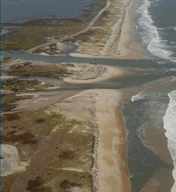
The east-facing coast, from Cape Hatteras to Oregon Inlet, also experienced waves and surge from the ocean, but surge was higher in the sound. Sections of Rodanthe and Pea Island National Wildlife Refuge were exposed to storm surge in Pamlico Sound of roughly six feet that contributed to the carving of channels through the island that breached a state highway at several locations. A total of five breaches were cut through the coastal landscape between Cape Hatteras and Oregon Inlet.
“Such multiple breaches, or new inlets, cut through the Outer Banks could take weeks to months to close on their own,” said Asbury (Abby) Sallenger, a U.S. Geological Survey oceanographer. “And without intervention like pumping sand, some could even persist indefinitely depending on the channel’s cross-section and the amount of water flushed through it on every tide.”
Three days after the landfall of Hurricane Irene, USGS scientists acquired detailed information of coastal change through aerial photography and an airborne lidar survey mission conducted with the National Oceanic and Atmospheric Administration.
Lidar, light detection and ranging, is a remote-sensing tool attached to an aircraft that uses laser pulses to collect highly detailed ground elevation data. Information obtained from the surveys allow scientists to discern the degree of changes to beaches and coastal environments and determine how much the land has eroded and where new inlets have cut through. The photo and lidar information should be useful in mitigation and restoration efforts like rebuilding N.C. Highway 12, which was severed in several locations by breaches cut through the barrier islands by Hurricane Irene.
Data acquired will also be used to make more accurate predictive models of future coastal impacts from severe storms and identify areas vulnerable to extreme coastal change.

Oblique aerial photograph of Pea Island National Wildlife Refuge, NC, looking north along the coast on August 30, 2011, three days after landfall of Hurricane Irene. Caption and photo source: USGS


