
Istambul. Astronaut photograph ISS032-E-17547 was acquired on August 9, 2012, with a Nikon D3S digital camera using a 400 mm lens, and is provided by the ISS Crew Earth Observations experiment and Image Science & Analysis Laboratory, Johnson Space Center. The image was taken by the Expedition 32 crew.
By M. Justin Wilkinson, Jacobs/ESCG at NASA-JSC,
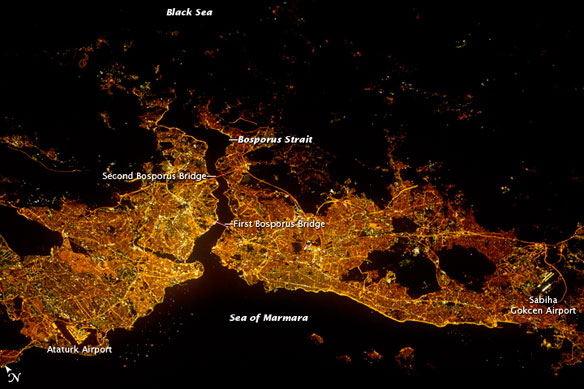
Most of Istanbul’s Asian suburbs (image right) appear in this night view from the International Space Station, but only about half the area of the city on the European side is visible. The margins of the metropolitan area are clearly visible at night, more so than in daylight images in daylight images.
The Bosporus strait (also spelled Bosphorus) famously separates the two halves of the city and links the small Sea of Marmara (and the Mediterranean Sea) to the Black Sea. The strait is 31 kilometers (19 miles) long, most of which is visible in this view.
The Bosporus is a very busy waterway, with larger ships passing north-south between the Black Sea and the Mediterranean, while competing with numerous ferries that cross east-west between the two halves of the city.
Apart from the Sea of Marmara and Black Sea, the other dark areas are wooded hills that provide open spaces for the densely populated city—one of the largest in Europe at 13.5 million inhabitants.
The old city of Istanbul occupies the prominent point at the southern entrance to the strait. The brighter lines crossing the metropolitan area the major traffic arteries; bright lights also mark the shorelines. The First Bosporus Bridge and Second Bridge (also known as the Fatih Sultan Mehmet Bridge) span the strait.
The brilliant lights of both international airports also stand out at image lower left and image lower right.


