By M. Justin Wilkinson, NASA / Earth Observatory;
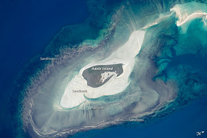
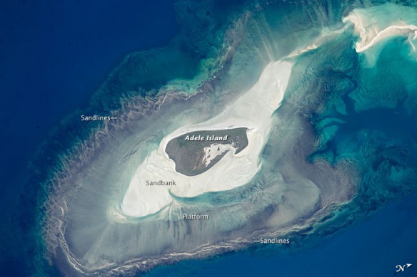
An astronaut aboard the International Space Station took this photograph of Adele Island, off of Australia’s north coast. The island is only 2.9 kilometers (2 miles) long, but the entire tidal zone—with concentric and extensive sandbanks—is 24.5 kilometers (15.2 miles) long.
The modern island is the dark central area, made up of a series of beach ridges built by sands washed up from the surrounding sandbanks during storms. The highest point is little more than 4 meters (13 feet) above sea level on this grassy but treeless island. A solar-powered lighthouse appears as a tiny white dot at the north tip of the island.
Adele Island has been classified as an important bird area because it is a breeding site of world importance for lesser frigatebirds and three other species. Efforts are underway to clear the island of Polynesian rats, which are a constant threat to the seabirds.
Lines on the wide platform around the island, at right angles to the shoreline, are probably produced by the high tides (6.3 meters, or 20 feet) at nearby Browse Island. Water floods towards the island, and then ebbs back out to sea—a radial pattern common on islands in this part of the world. Wave and tide movements give different sand patterns on opposite sides of Adele Island. The eastern shore shows tightly packed parallel lines of white sand, perhaps as a result of wave action concentrated in a narrow zone related to this steep slope. On the gentler western slope, the same sandy material displays a V-shaped pattern, possibly due to the longer in-out movement of water with each tide.
Shallow water surrounding the island is light blue, compared with the deeper open ocean. During times of low sea level (repeatedly during the glacial stages of the past 1.7 million years), the entire platform and surrounding zones would have been dry ground on a much larger island.


