New low-altitude aerial photos of Southeastern beaches taken before and after Hurricane Matthew passed offshore show a new storm-cut inlet, and roads, dunes and structures lost.
By USGS;
Hurricane Matthew’s storm surge and waves overwashed about 15 percent of the sand dunes on Florida’s Atlantic coast, 30 percent along Georgia’s coastline, and 42 percent of dunes on South Carolina’s sandy beaches as the powerful storm brushed past the Southeastern states October 6-9, according to USGS experts’ preliminary review of USGS low-altitude before-and-after images along of the coast and NOAA photographs collected after the storm.
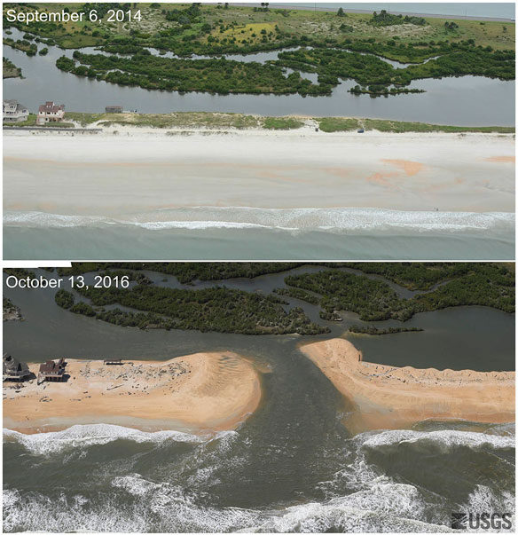
Low-altitude oblique photography taken before Hurricane Matthew (Sept. 6, 2014) and after (Oct. 13, 2016) shows the storm cut a new inlet between the Atlantic Ocean and the Matanzas River near St. Augustine, Florida, stripping away a 3.7 meter (12-foot) dune and carrying sand into the estuary.Public domain.
The hurricane’s impact on Southeastern shorelines was less extensive than a pre-storm prediction, which called for 24 percent of Florida’s Atlantic coast to be overwashed by the storm surge, said USGS research oceanographer Joseph W. Long. That forecast was based on a worst case scenario, Long said: the maximum waves forecast by the National Hurricane Center striking the coast simultaneously with the maximum storm surge.
Long and his fellow scientists on the USGS National Assessment of Coastal Change Hazards storm team, headed by research oceanographer Hilary Stockdon, are working on a detailed assessment of Matthew’s effects on the region’s vulnerable shorelines. They are now comparing low-altitude, oblique aerial photos taken in September 2014 to photos collected Oct. 13-14, about a week after the storm.
“High altitude images give us a big picture view of the coastline, and that’s very useful to identify large areas of overwash, but we can’t see the dunes in those images,” Long said. “These low-altitude photos give us a clear view of the dune itself. We can see whether the storm surge altered or eliminated that protective barrier, and what happened to the houses and boardwalks and sea walls behind it.”
When a storm is about to strike the U.S. Atlantic coast, the team predicts the likelihood of coastal erosion and other changes, using a computer model that incorporates the National Hurricane Center’s storm surge predictions and National Oceanic and Atmospheric Administration wave forecasts. The USGS model adds information about the beach slope and dune height to predict how high waves and surge will move up the beach.
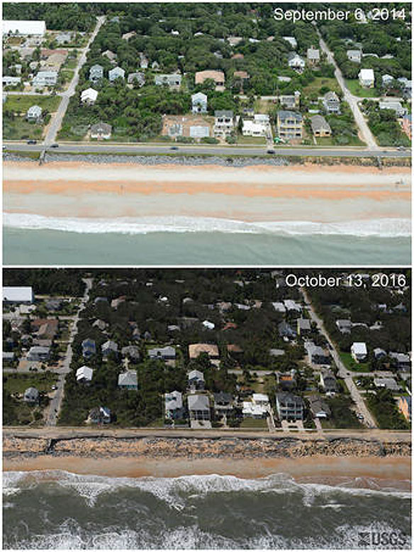
Low-altitude oblique photography taken before Hurricane Matthew (Sept. 6, 2014) and after (Oct. 13, 2016) in Flagler Beach, Florida, shows that waves washed away part of Highway A1A and obliterated a 5.2-meter (17-foot) dune.
The model forecasts three types of storm impact to the dunes that protect coastal communities: erosion, overtopping, and inundation, or flooding that reaches over and behind the dunes. After a storm has passed, the researchers test the model’s accuracy using information about the state of the dunes from before-and-after photographs and other data.
In Florida, the state which had the closest brush with Matthew, an estimated 86 kilometers (53 miles) worth of dunes and other coastal structures were overtopped. A preliminary review found 52 kilometers (32 miles) worth of shoreline in Georgia and 124 kilometers (77 miles) in South Carolina were overwashed, mostly in lightly populated areas. Team members are still reviewing aerial photos from North Carolina, where the hurricane’s impacts were dominated by heavy rainfall that resulted in extensive flooding in inland areas.
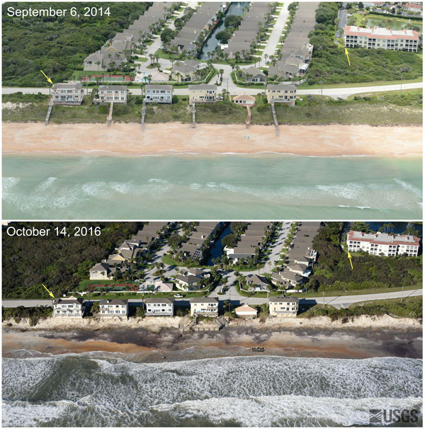
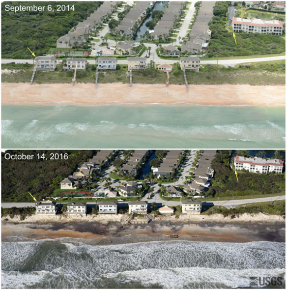
The images clearly capture the damage at Florida’s Vilano Beach, north of St. Augustine, where the storm surge and wave runup washed away a five-meter (16-foot) sand dune, destroying oceanfront homes’ boardwalks and decks. South of St. Augustine, the storm surge opened up a new inlet between the Atlantic Ocean and the Matanzas River, stripping away a 3.7 meter (12-foot) dune and carrying most of its sand into the estuary. And further south in the town of Flagler Beach, the powerful waves washed away a portion of Highway A1A, closing the beachfront highway indefinitely, and obliterated a 17-foot dune.
On Oct. 28 the U.S. Army Corps of Engineers, in collaboration with the USGS, is scheduled to begin a month-long series of data collection in the Southeastern U.S. coast using airborne lidar, a technology that bounces beams of laser light at the ground to produce detailed elevation information about the surface below. Using that information, the USGS researchers can estimate the volume of sand that Hurricane Matthew moved off of Southeastern beaches, measure the height and breadth of the remaining dunes, and be ready to forecast the erosion potential of the next storm.
See more before-and-after-Hurricane Matthew photos from Florida and check the storm team’s Hurricane Matthew web page where photos from other states will added as they become available.


