
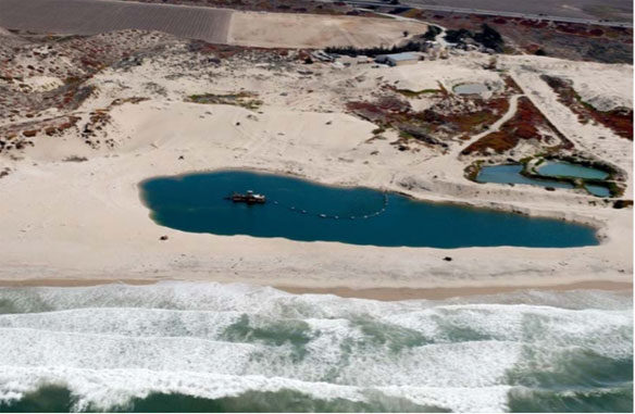
Figure 1. Aerial view of the Lapis Sand Plant, Marina, CA.
© By Robert S. Young, PhD, PG,Professor of Geology, Western Carolina University Director, Program for the Study of Developed Shorelines
Purpose and Overview:
The City of Marina commissioned this report to assist in its management and decision‐making for coastal property and resources within the City’s jurisdiction. Consistent with that purpose, this report provides a review and synthesis of available documentary information and scientific literature addressing the impact of current sand mining activities within southern Monterey Bay. To assist in preparation of this report, in March 2017, the author visited the Lapis Sand Mine, the site of current beach sand mining activities in the City of Marina. It is my understanding that the Lapis Sand Mine is the only coastal mining activity in Monterey County at this time, and that other sand mining operations that previously operated along the Monterey Bay shoreline ceased operations in the late 1980s. Accordingly, all references to ongoing beach sand mining in this report are to the Lapis Sand Mining operation in the City of Marina.
This report is intended for an informed lay audience and, in particular, for City of Marina officials seeking to base coastal management decisions on the best available science. It provides a distillation of the most relevant facts and science related to the basic question: “Are sand mining activities at the Lapis Sand Mine (Figure 1) impacting the sediment budget and shoreline change rates in the vicinity of the mine?” Based on my review of the available information, data, and scientific literature, I conclude that beach sand extraction by the Lapis Sand Mine constitutes a significant source of sand loss from the southern Monterey Bay central littoral cell and, as a result, is causing or contributing to significant adverse effects on coastal property, resources, and uses.
The portions of southern Monterey Bay shoreline have the highest erosion rates in the state. None of the documents reviewed for this report can offer any explanation for these anomalously high erosion rates beyond the sand extraction from the littoral zone at the Lapis Mine. The overwhelming evidence leads me to conclude that continued sand mining activities have led to a substantial sand deficit in southern Monterey Bay. This sand deficit is driving these anomalously high rates of coastal erosion. In order to grapple with the serious erosion problems in southern Monterey Bay, I recommend that the City of Marina pursue options to stop beach sand mining activities at the Lapis facility.
Introduction:
Sand is to beaches and shorelines, as water is to western urbanization and agriculture. Sand moves between sources and temporary sinks. Preserving this sand and its movement is the key to maintaining the broad coastal economy, providing storm protection to infrastructure and shoreline development, ensuring recreational use of a state’s beaches, and protecting coastal ecosystems. This free movement of sand between sources and sinks is commonly referred to as the Sand Sharing System. Many legislative and rule‐making bodies have codified the importance of the Sand Sharing System.1
1For example, the State of Georgia Code § 12‐5‐231 (2015) reads:
- The General Assembly finds and declares that coastal sand dunes, beaches, sandbars, and shoals comprise a vital natural resource system, known as the sand‐sharing system, which acts as a buffer to protect real and personal property and natural resources from the damaging effects of floods, winds, tides, and erosion. . . The General Assembly further finds that this sand‐sharing system is a vital area of the state and is essential to maintain the health, safety, and welfare of all the citizens of the state. . . It is declared to be a policy of this state and the intent of this part to protect this vital natural resource system by allowing only activities and alterations of the sand dunes and beaches which are considered to be in the best interest of the state and which do not substantially impair the values and functions of the sand‐sharing system and by authorizing the local units of government of the State of Georgia to regulate activities and alterations of the ocean sand dunes and beaches . . . .
This Sand Sharing System is based on the uncontroversial, science‐based concept that sand is constantly being exchanged from one coastal feature to another: from dunes to the beach, from one stretch of shoreline to the next, from the beach to the nearshore sand bars. Removal of sand from the system will impact all portions of the system eventually.
The Sand Sharing System can be described by the development of a sediment budget. Sediment (sand) budgets are important tools in understanding regional sand supply, loss, and movement. Best and Griggs, 1991; Rosati, 2005. A sand budget itemizes and quantifies the sources (inputs), sinks (outputs), and movement of the sand within a littoral cell. A littoral cell is a relatively self‐contained section of coast where the sand circulates, i.e “a defined length of shoreline along which the cycle of sediment erosion, transportation, and deposition is essentially self‐contained.” Philip Williams & Associates, 2008 at 21.
Littoral cells are separated from each other by features that block the exchange of sand, like a rocky headland. The south Monterey Bay shoreline has been divided into sub‐cells, which are essentially delineated by differing sand transport directions (shown in Figure 2). Patsch and Griggs, 2007. The Lapis Mine sits approximately in the middle of the Central sub‐cell, stretching from the Salinas River to Sand City in the south. The basic sources and sinks within this sub‐cell are listed in Table 1.
Numerous researchers have quantified the sediment movement within the southern Monterey Bay littoral cell. The sediment budgets in these studies vary depending on the area within Monterey Bay they are considering and the type of sediment being quantified (e.g. beach sand vs. all sediment). Patsch and Griggs, 2007; Jones and Griggs, 1985; Smith, 2005; Philip Williams & Associates et al., 2008; Thornton, 2016. However, all of the studies conclude that sand mining removes a significant amount of sand from the sand budget and is contributing to shoreline erosion.
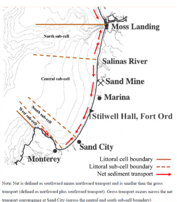
Figure 2. Southern Monterey Bay Littoral Sub‐Cells and Net Sediment Transport. Source: Figure 12 from Philip Williams & Associates et al. (2008).
The most recent sediment budget for the Central sub‐cell was presented by Thornton (2016) and is summarized in Table 1. It is significant that these data are presented in the peer‐reviewed scientific journal, Marine Geology. This offers a high level of confidence in the data quality.
This sand budget is useful because it is focused on the Central sub‐cell and considers only beach compatible sand. Thornton’s recent sediment budget indicates that the biggest source of sand in the southern Monterey Bay is from dune erosion. However, only about 25% of the dune sand is coarse enough to stay on the beach; the remaining 75% of the finer grained sand ends up being transported offshore (or blown back into the dunes). Thornton, 2016. Because CEMEX mines the coarse beach sand tracked in his budget, Thornton’s 2016 budget is the most appropriate sediment budget to use for the purposes of determining the sources and sinks of the sand that feed the beaches in the City of Marina.2
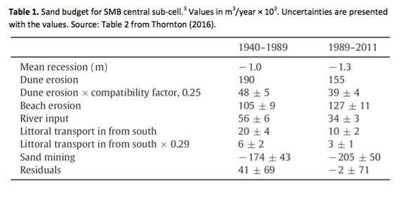
Dunes contribute an estimated sand volume of 155,000 cubic meters/year to the littoral system. Thornton 2016. There is also a small sediment input to the Central sub‐cell system from the Salinas River that has decreased through time.4 The sand input to the Central sub‐cell from riverine sources is relatively modest – about 34,000 cubic meters/year – because most sand from the Salinas River is transported north.5 Thornton, 2016; Patsch and Griggs, 2007.
- 2 Only sand with a grain size greater than .25 mm typically stays on the beach. Thornton, 2016. This coarse beach size sand is the type of sand that CEMEX mines. Thornton, 2016. Therefore, other broader sediment budgets showing large amounts of sand being lost offshore are not relevant to the analysis of impacts from sand mining. See, e.g., Philip Williams & Associates et al., 2008 at 46.
- 3 Beach sand budgets were calculated for two time periods to examine the impact of sand mining: “The first budget is calculated from 1940 to 1989 during the time of intensive drag‐line sand mining of the surf zone focused on the south end of the littoral cell. The second budget is calculated from 1989 to 2011 after all the drag‐line mines were closed leaving only a dredge pond mining operation at the north end of the littoral cell.” Thornton, 2016.
- 4 Two dams, built in 1941 and 1961, are estimated to have reduced the total annual sediment input from the Salinas river by 33%. Willis and Griggs, 2003. However, this does not have a major impact on the Central sub‐cell sand budget since most of the sand from the Salinas is “is driven northward by the dominant littoral drift” and is eventually carried into the Monterey Submarine Canyon. Patsch and Grigggs, 2007.
- 5Other studies estimate an even lower volume of sediment – less than 8,000 cubic meters – traveling south from the Salinas river. Philip Williams & Associates et al., 2008.
Sand within this cell moves from dunes to the beach as the shoreline recedes. It also moves back and forth along the shore by waves (this is known as longshore sediment transport or littoral drift). But, for the most part, the sand remains in the cell as a part of the Sand Sharing System, maintaining a balance that stabilizes the shoreline and the beaches. If there is a balance between sand entering and leaving the beach, then the shoreline position will remain stable. If there is a deficit of sand entering the beach, the shoreline will move landward, or erode. Sand mining that removes sand from this active system becomes a permanent sink— taking away sand that will never return. Thornton (2016) finds that sand mining is the only significant sink (or loss) of beach size sand in the sand budget for this sub‐cell.
Impacts of sand mining:
There is no scientific dispute that removing sand from the active Sand Sharing System will decrease the amount of sand available for building and maintaining beaches. The question for setting policy direction is whether such removal is significant enough to have a long‐term effect on shoreline position, beach volume, and beach/dune erosion. The first step in understanding the potential impact of the sand removal at the Lapis Mine is to determine if the sand is actually being removed from the active Sand Sharing System (from the littoral zone).
All of the available evidence shows that sand is being removed from the littoral zone. The dredging activity relies on a suction dredge operating in an artificial lagoon immediately adjacent to the beach. The lagoon is filled during coincident high tides and large waves, and the sand is removed by the dredge for processing. The sand filling the lagoon comes directly from the beach and nearshore immediately in front of the mine (Figure 3). The lagoon also traps sand that is moving in either direction along the beach. During a site visit by the author in 2017, recent storm waves had clearly reached well past the seaward portion of the lagoon (Figure 4). The visible wrack line was across the footprint of the lagoon. It is clear that the sand repeatedly filling the lagoon could not be coming from anywhere else other than the adjacent beaches and nearshore. Numerous peer‐reviewed papers examining the sediment budget of southern Monterey Bay support the conclusion that the sand being removed at the Lapis Mine is coming from the local Sand Sharing System; and thus, it is a permanent, annual sink (deficit) in the littoral cell sand budget. Patsch and Griggs, 2007; Jones and Griggs, 1985; Smith, 2005; Philip Williams & Associates et al., 2008; Thornton, 2016.
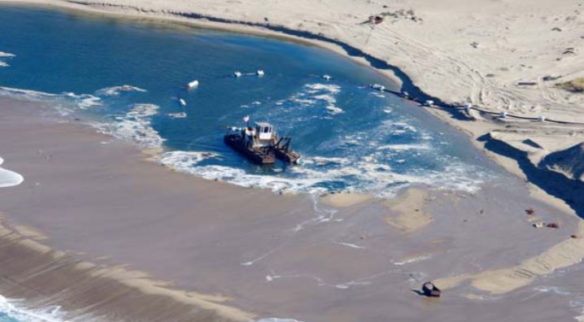
Figure 3. Image of the sand mining operations at the CEMEX Lapis Mine. Note the fact that waves are pouring over the berm and into the lagoon. Effectively, the mining here is occurring in the active surf zone. Photo credit: Gary Griggs
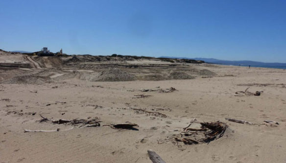
Figure 4. In a March 2017 visit to the site, the author noted that the lagoon had been filled by storm waves and heavy equipment. The high tide wrack lines crossed the tracks of the equipment and the outer edge of the lagoon footprint.
The Lapis Sand Mine has not provided current extraction volumes to the City of Marina, nor publicly shared annual extraction information. Thornton (2016) estimated the sand removal to be approximately 205,000 cubic meters per year based on a CEMEX Annual Report from 2000. The Coastal Regional Sediment Management Plan for Southern Monterey Bay (Philip Williams & Associates et al., 2008) used an estimate of around 153,000 cubic meters per year. Both numbers represent a significant removal of sand from the littoral cell. It is important to keep in mind that these numbers represent average, annual removal. It is likely that the sand volume mined each year has fluctuated from slightly below to above this average rate range.
As Table 1 indicates, the total sand volume exchanged annually in the sub‐cell is estimated at approximately 326,000 cubic meters per year. Therefore, sand mining at the Lapis site is removing approximately 47% to 63% of the local sand budget.
To put these numbers in perspective, the Lapis mining operation is removing somewhere around 750,000 to just over 1 million cubic meters of sand every five years. This is the equivalent of a large beach nourishment project for many beaches in the United States. For example, a proposed U.S. Army Corps of Engineers beach nourishment project along an eroding stretch of the Southern California coast would (1) initially place 260,000 cubic meters of replacement sand on the Encinitas beach, with 168,000 cubic meters of replacement sand added every five years and (2) initially place 535,000 cubic meters of sand along Solana Beach, with planned renourishment of 221,000 cubic meters every ten years.6 The projected cost for this project is $165 million, with annual costs of over $3.5 million.7 Given the costs of such projects, it is difficult, from a public policy perspective, to justify a similar beach nourishment effort along the similarly erosive southern Monterey Bay coast when the Lapis Sand Mine will quickly offset any replenishment benefits by sand removal for commercial profit.
Evidence of impact:
Removal of sand at these volumes, over the long term, from a relatively closed littoral cell necessarily causes a negative impact on the coastal systems within that cell. Because the longshore sediment transport rates in southern Monterey Bay are small (on the order of 10,000 to 20,000 cubic meters per year) relative to the amount of material being removed annually at the Lapis Sand Mine, the greatest sand deficit will be closest to the mine, within the municipality of Marina(Figure 5). Thornton, 2017; Philip Williams & Associates et al., 2008.
- 6 See U.S Army Corps of Engineers Project Description (numbers converted from cu yards to cu meters): http://www.spl.usace.army.mil/Missions/Civil‐Works/Projects‐Studies/Solana‐Encinitas‐Shoreline‐Study/.
- 7Cost estimates are the most recent numbers in the media from December 2016:http://www.thecoastnews.com/2016/12/15/federal‐funding‐for‐50‐year‐sand‐project‐approved/
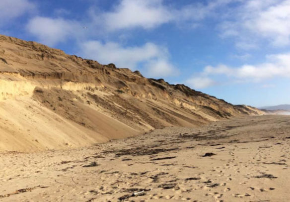
Figure 5. Typical section of rapidly eroding shoreline with the City of Marina.
A comprehensive evaluation of coastal erosion rates for the State of California conducted by the United States Geological Survey (Hapke et al., 2006) shows that the Central sub‐cell has the highest erosion rates in the state (Figure 6).8 Hapke et al. (2006) and other studies looking at long‐term average erosion rates show that erosion rates have increased dramatically over the last century in the southern Monterey Bay. This is illustrated by how much higher recent erosion rates are than long‐term erosion rates. For Marina State Beach, Hapke et al. (2006) calculated an average erosion rate from 1910‐2002 of 1.4 to 2.0 ft/yr and from 1970 to 2002 of 3.1 to 5.2 ft/year.9 Other studies support the increasing trend in erosion rates in southern Monterey Bay over the past century. Thornton, 2006; Jones and Griggs, 1985. The difference between the long‐term erosion rates (which include a period of time before sand mining and older mining methods before the suction dredge) and the short‐term erosion rates (including only the period of modern mining with current sand extraction amounts) in Hapke et al. 2006 is significant: it demonstrates that the impact of current sand mining practices on local shorelines has been an increase in the rate of erosion.
- 8Hapke et al. (2006) calculated an average erosion rate from 1970 to 2002 of 4.0 ft/year for southern Monterey Bay between the Salinas River and Monterey. Thornton et al., 2006 estimated approximately 3.0ft/year of erosion from 1985 to 2005. Smith (2005) calculated erosion rates in southern Monterey Bay at 1m/yr (3.28 ft/yr).
- 9These results are broadly consistent with the erosion rate results in Thornton et al. (2006). Thornton et al., (2006) estimated approximately 1.0 ft/year of erosion in Marina from 1940‐1985 and 4.7 ft/year of erosion in Marina from 1985 to 2005.
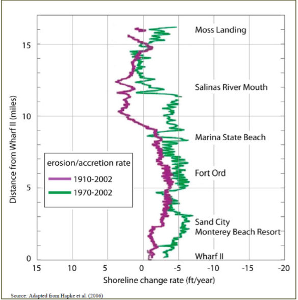
Figure 6. Dune Erosion Rates in Southern Monterey Bay. Source: Figure 18 from Philip Williams & Associates et al. (2008).
None of the documents reviewed for this report can offer any explanation for these anomalously high erosion rates beyond the sand extraction from the littoral zone at the Lapis Mine. The overwhelming evidence leads me to conclude that continued sand mining activities have led to a substantial sand deficit in southern Monterey Bay. This sand deficit is driving high rates of coastal erosion.
Coastal management implications and recommendations:
In the vast majority of coastal communities in the continental United States, rising sea level is the primary driver of long‐term coastal erosion. In those localities, managers have little choice but to accept the fact that halting global sea‐level rise is not a problem they can tackle alone. Coastal management, therefore, becomes an exercise in planned adaptation and perhaps some degree of shoreline stabilization— typically with beach nourishment as a key component.
In southern Monterey Bay, municipalities and coastal managers are confronted with a unique complicating factor for the development of any sediment management plan (e.g. Philip Williams & Associates et al., 2008) or erosion mitigation plan (e.g. ESA PWA, 2012). Coastal erosion is being exacerbated by (at best) or driven by (at worst) the direct and intentional removal of sand from the Sand Sharing System.
Given the costs and other significant disadvantages of long‐term beach nourishment programs, coastal managers can best serve the public interest by first attempting to eliminate sand sinks that are contributing to coastal erosion. In southern Monterey County, the Lapis Sand Mine is a substantial sand sink that is removing roughly 50 percent or more from the littoral system sand budget and, therefore, is a significant source of the coastal erosion that is negatively affecting coastal property, resources, and uses. Mitigating this ongoing erosion with hard structures (seawalls, revetments, and other coastal armoring) is not a sound policy response to the problem, as seawalls and groins will also directly interfere with the Sand Sharing System and create additional sand deficits.
Before municipalities and regional managers can meaningfully implement any serious, comprehensive, long‐term coastal planning, they will have to deal with the harmful sand deficit caused by the Lapis Sand Mine. Based on my review of the available information and literature and my professional expertise, I recommend that the City of Marina pursue options for halting the beach sand mining activities at the Lapis facility.
About the Author
Robert S. Young is the Director of the Program for the Study of Developed Shorelines, a joint Duke University/Western Carolina University venture. He is also a Professor of Geology at Western Carolina University and a licensed professional geologist in three states (FL, NC, SC). The Program for the Study of Developed Shorelines (PSDS) is a research and policy outreach center serving the global coastal community. The primary mission of PSDS is to conduct scientific research into coastal processes and to translate that science into management and policy recommendations through a variety of professional and public outreach mechanisms. The Program specializes in evaluating the design and implementation of coastal engineering projects. In California, Dr. Young is the Principal Investigator of a National Park Service project to map the vulnerability of every building, road, and facility in the state’s National Parks.
References
- 2012 SMARA Mine Inspection, CEMEX Lapis Sand Plant, CA Mine No. 91‐27‐0006 (Jan. 17, 2013). Prepared for State Mining and Geology Board.
- Best, T. and Griggs, G., 1991. A Sediment Budget for the Santa Cruz Littoral Cell, California. Society for Sedimentary Geology Special Publication No. 46.
- Brew, D.S., Battalio, R.T., Thornton, E.B., Davenport, C., and Damitz, B. 2011. Coastal Regional Sediment Management Planning In Southern Monterey Bay, California. Littoral 2010 – Adapting to Global Change at the Coast: Leadership, Innovation, and Investment, 05009.
- ESA PWA, Evaluation of erosion mitigation alternatives for southern Monterey Bay (May 30, 2012). Prepared for by ESA PWA with Ed Thornton, Meg Caldwell, Philip King, Aaron McGregor for the Monterey Bay Sanctuary Foundation and The Southern Monterey Bay Coastal Erosion Working Group.
- Griggs, G. 1994. California’s Coastal Hazards. Journal of Coastal Research Special Issue No. 12. Coastal Hazards 1‐15.
- Hapke, C., Reid, D., Richmond, B.M., Ruggiero, P., List, J., 2006. National assessment of shoreline change part 3; historical shoreline change and associated coastal land loss along sandy shorelines of the California coast. U.S. Geological Survey Open‐File Report. 2006‐1219.
- Jones, G. and Griggs, G. 1985. Erosion along an “Equilibrium Coastline,” Southern Monterey Bay, California in in California’s Battered Coast: proceedings from a Conference on Coastal Erosion, San Diego, February 6‐8, 1985, p. 102‐119.
- Orzech, M.D., Thornton, E.B., MacMahan, J.H., O’Reilly, W.C., Stanton, T.P., 2010. Alongshore rip channel migration and sediment transport. Marine Geology 271, 278–291.
- Patsch, K. and Griggs, G. 2006. ©Littoral cells, sand budgets, and beaches: Understanding California’s shoreline. Institute of Marine Sciences, University of California, Santa Cruz.
- Patsch, K., Griggs, G., 2007. Development of Sand Budgets for California’s Major Littoral Cells. California Coastal Sediment Management Workgroup.
- Philip Williams & Associates, Ltd [PWA], Thornton, E., Dugan, J., Halcrow Group, 2008. < a href=”http://www.dbw.ca.gov/csmw/pdf/smontereybay_crsmp_3nov2008.pdf”>Coastal Regional Sediment Management Plan for Southern Monterey Bay. Prepared for Association of Monterey Bay Area Governments and the Coastal Sediment Management Workgroup.
- Pohl, A. and Johnston, L. 2012. Lapis sand dollars: An economic analysis of non‐market impacts of Lapis Sand Mine in southern Monterey Bay. Working Paper, Center for the Blue Economy, Middlebury Institute of International Studies at Monterey.
- Quan, S., Kvitek, R., Smith, D., and Griggs, G. 2013. Using vessel‐based LIDAR to quantify coastal erosion during El Niño and inter‐El Niño periods in Monterey Bay, California. Journal of Coastal Research 29(3), 555‐565
Front page featured image by © Gary Griggs
RESOLUTION NO. 2017
A RESOLUTION OF THE CITY COUNCIL OF MARINA FINDING THE CURRENT OPERATION OF THE CEMEX MINE MEETS THE ELEMENTS REQUIRED FOR A PUBLIC NUISANCE DUE TO ITS EROSIVE EFFECTS ON THE SOUTHERN MONTEREY BAY COAST AND FINDING THE CEMEX MINE TO BE IN VIOLATION OF SECTIONS 17.41.260 AND 17.25.030 OF THE MUNICIPAL CODE
WHEREAS, the CEMEX Sand Mine facility, located between Lapis Road and the Monterey Bay in the City of Marina (hereinafter “Lapis Sand Mine”), extracts large volumes of sand from an artificial dredge pond located on the beach adjacent to the shoreline; and
WHEREAS, the CEMEX dredge operations are maintained by mechanical manipulation of the beach dredge pond, which changes shape and location over time to draw in coarse beach sand from the nearshore and public tidelands during high tide events; and
WHEREAS, the coastal dunes and beach on the CEMEX property contain federally threatened and endangered species and habitat that has been designated as Environmentally Sensitive Habitat Area under the Coastal Act; and
WHEREAS, the Lapis Sand Mine operates and maintains sand-moving equipment, moves wet/dry sand, and extracts sand within an environmentally sensitive beach habitat; and
WHEREAS, the Lapis Sand Mine stockpiles its extracted sand in the sensitive coastal dune habitat; and
WHEREAS, the Lapis Sand Mine operations degrade the environment by interfering with sensitive coastal resources and habitat; and
WHEREAS, the southern Monterey Bay coast suffers from extremely high rates of erosion; and
WHEREAS, the Lapis Sand Mine annually extracts an estimated 153,000 to 205,000 cubic meters of sand; and
WHEREAS, the City resolved on March 15, 2016 to authorize the City Manager “to request the California Coastal Commission to assist the City with and/or assume responsibility for, in coordination with the City, any enforcement proceedings that may be pursued relative to possible violations of the California Coastal Act and the Marina Local Coastal Program by the Cemex Sand Mining operations”; and
WHEREAS, on March 17, 2016, the California Coastal Commission issued a Notice of Intent to Commence Cease and Desist Order and Restoration Proceedings and Administrative Civil Penalties Proceedings against CEMEX for unpermitted development, including sand dredging and extraction and related activities and development; and
WHEREAS, on May 16, 2017, the State Lands Commission issued a letter to CEMEX concluding that the Lapis Sand Mine is engaged in unlawful conversion of state public trust resources and indicating that CEMEX must either immediately submit a lease application to the Commission or cease dredge pond operations because of the financial and resource impacts its operations have on the state; and
WHEREAS, the City commissioned Dr. Robert S. Young, Ph.D., Director of the Program for the Study of Developed Shorelines and a Professor of Coastal Geology at Western Carolina University, to independently review the available information and academic literature on coastal erosion in the southern Monterey Bay and prepare an expert report to evaluate the effects, if any, of the Lapis Sand Mine on coastal erosion; and
WHEREAS, Dr. Young concluded that the Lapis Sand Mine constitutes a significant source of sand loss from the southern Monterey Bay littoral cell and, as a result, is causing erosion and significant adverse effects on coastal property, resources, and uses; and
WHEREAS, there is a scientific consensus that the Lapis Sand Mine extracts sand at a level that significantly contributes to high rates of erosion along the southern Monterey coast; and
WHEREAS, erosion due to the Lapis Sand Mine extraction activities causes significant physical and economic injury to public and private property along the southern Monterey coast; and
WHEREAS, the Lapis Sand Mine interferes with the public’s access to and use and enjoyment of the beaches along Marina’s coastline in a customary manner; and
WHEREAS, section 3479 of the California Civil Code states: “Anything which is injurious to health, including, but not limited to, the illegal sale of controlled substances, or is indecent or offensive to the senses, or an obstruction to the free use of property, so as to interfere with the comfortable enjoyment of life or property, or unlawfully obstructs the free passage or use, in the customary manner, of any navigable lake, or river, bay, stream, canal, or basin, or any public park, square, street, or highway, is a nuisance.”; and
WHEREAS, section 3480 of the California Civil Code states: “A public nuisance is one which affects at the same time an entire community or neighborhood, or any considerable number of persons, although the extent of the annoyance or damage inflicted upon individuals may be unequal.”; and
WHEREAS, the current operations of the Lapis Sand Mine appear to this Council to meet the required elements for a public nuisance under sections 3479 and 3480 of the California Civil Code; and
WHEREAS, section 731 of the California Code of Civil Procedure authorizes the City Attorney, at the direction of the City Council, to bring a civil action in the name of the people of the State of California to abate a public nuisance; and
WHEREAS, section 17.41.260 of the Municipal Code requires “all operators of existing mining operations” to submit to the planning department (1) a brief statement specifying the approximate annual volume of sand being removed and (2) an accurate cronaflex ortho-topographic map by January 1st of every year “[i]n order to establish reference base data for the purpose of determining whether or not any particular mining activity constitutes new mining activity and to monitor shoreline erosion”; and
WHEREAS, City records indicate that the Lapis Sand Mine has not complied with these requirements since 1992, when the prior facility owner submitted extraction levels for year 1991; and
WHEREAS, section 17.25.030 of the Municipal Code requires a coastal development permit for conditional uses, such as dredge ponds, in the Coastal Conservation and Development District; and
WHEREAS, the CEMEX Sand Mine is located in the Coastal Conservation and Development District and CEMEX has not obtained a coastal development permit; and
WHEREAS, this resolution does not enjoin CEMEX from continuing sand mining activities unless and until the City Attorney seeks judicial enforcement of this nuisance declaration and a judicial order enjoining further sand mining; and
WHEREAS, section 17.60.040 of the Municipal Code empowers the City Council to direct the City Attorney to either commence civil action or abatement proceedings for violations of the City’s zoning title, including sections 17.41.260 and 17.25.030; and
WHEREAS, the action below is taken by this Council following careful consideration of a) all written materials submitted by staff, consultants, and members of the public, and b) comments made at the public hearing by staff, consultants, the public, and members of this Council.
NOW, THEREFORE, BE IT RESOLVED that the City Council of the City of Marina does hereby:
1. Approve this Resolution; and
2. Authorize the City Attorney to pursue the possibility of a civil action against CEMEX to declare and abate the Lapis Sand Mine as a public nuisance under sections 3479 and 3480 of the California Civil Code pursuant to California Code of Civil Procedure section 731; and
3. Authorize the City Attorney to pursue the possibility of commencing action or proceedings for abatement under section 17.60.040 of the Municipal Code due to CEMEX’s continued violations of the reporting requirements under section 17.41.260 of the Municipal Code; and
4. Authorize the City Attorney to pursue the possibility of commencing action or proceedings for abatement under section 17.25.030 of the Municipal Code; and
5. Direct the City Attorney, at such time as he deems appropriate, to report back to the City Council, in closed session, with regard to which of the above-listed litigation actions he recommends and has decided to pursue on behalf of the City.
PASSED AND ADOPTED by the City Council of the City of Marina at a regular meeting duly held on the 6th of June, 2017, by the following vote:
AYES, COUNCIL MEMBERS:
NOES, COUNCIL MEMBERS:
ABSENT, COUNCIL MEMBERS:
ABSTAIN, COUNCIL MEMBERS:
___________________________
Bruce Delgado, Mayor
ATTEST:
____________________________
Anita Sharp, Deputy City Clerk


