


Nelson Rangel-Buitrago, Adriana Gracia, Grupo de Geología, Geofísica y Procesos Marino-Costeros, Universidad del Atlántico Barranquilla, Atlántico, Colombia, and William J. Neal Department of Geology, Grand Valley State University, Allendale, Michigan.
One of the most remote and youngest inhabited volcanic islands in the world is Te Pito o Te Henua Island, or as more commonly known: Easter Island (Rapa Nui or Isla de Pascua). World famous for its mysterious monumental statues (moai) erected by the early Rapa Nui people, the island is located in the southeastern Pacific Ocean nearly 3,650 km west of Chile; more than 2,000 km from the nearest inhabited land, being the southeastern most point of the Polynesian Triangle in Oceania and one of the most isolated places on the planet (Figure 1). This Chilean island of 164 km2 is part of the administrative Valparaíso Region (V region) that also encompasses the island of Isla Salas y Gomez, located 385 km to the east. The island shares with the Juan Fernandez Islands the constitutional status of “special territory” of Chile. In 1995, UNESCO named Easter Island a World Heritage Site, and much of the island is protected within the Rapa Nui National Park (45% of the island).
Most travelers to the island are drawn there by the mystery of the large statues and associated archaeology of the lost culture that produced these monuments (Figure 2), and a later “birdman” culture. Numerous authors have treated these subjects, including presentations of this lost, isolated society as an example of humans contributing to the collapse of the very ecosystem on which they relied for existence.
The Polynesian discoverers/colonizers of the island found a tropical paradise, abundant vegetation, fish, shellfish, birds, and palm forests that provided lumber for their canoes as well as cloth and rope. The forest provided cover for shade crops, water retention, and a deterrent to soil erosion.
“The island’s volcanic origin has generated kilometers of amazing rocky coastline, dominated by erosional features. ”
— N.Rangel-Buitrago, A. Gracia & W. Neal
It’s a reasonable assumption that as the moai construction grew, and statues were moved to other parts of the island, that logs and polls were used to move these massive monuments. The resulting deforestation then led to a cascading effect of loss of boat-building materials (limiting fish harvest), crop losses, loss of ground cover, increased soil erosion, and a decline in the bird population. Some contend that part of this collapse was also due to climate change from the Little Ice Age. Evidence points to a resulting social breakdown, conflict, and starvation. Then the arrival of slavers from South America and the introduction of western diseases contributed to the final population decline.
The focus here, however, is on the island’s shoreline which begins with the geology. The island’s location is the result of the coalescence of three shield volcanoes that erupted between about 770,000 and 100,000 years ago (Rano Kau, Poike, and Terevaka) at the boundary of the Easter Microplate and the Nazca Plate, and are part of the Easter Sea Mount Chain. These volcanoes formed over a hot spot and grew from the seafloor to emergence. The rocks of the island have been mapped as seven distinct volcanic groups, reflected in different rock types, landforms, and associated events. Basalt and hawaiite (olive basalt) lava flows are the dominant rock types. Rano Raraku, a volcanic crater and site of the moai quarry, and Ranu Kau, a crest caldera (Figure 3), are large volcanic features. A few small cinder cones reflect some younger eruptions.
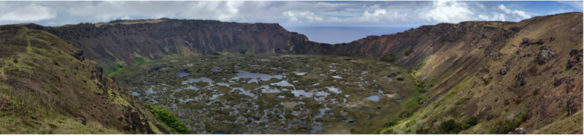
Figure 3. Rano Kau Volcano in the SW arm of the island is marked by a summit caldera that holds one of the islands few fresh-water lakes and wetland.
Sea Cliffs and Beaches
The island’s volcanic origin has generated kilometers of amazing rocky coastline, dominated by erosional features. Sea cliffs ranging from a few meters in height to those that reach 300 m are most extensive (Figures 4 and 5). Small islets (Motu-Nui, Motu-Iti, and Motu-Kaokao located in the southwest) and sea stacks are erosional remnants of the former coast (Figure 6). Erosional shore platforms now make up some of the relative flat land areas bordering the shore (Figures 7 and 8). Caves in these coastal cliffs abound, but rather than being true sea caves, many are exposed lava tubes, and consist of hidden rooms joined by narrow tunnels that often extend far into the lava beds (Figures 9 and 10).
Important:
Cliffed areas in general are dangerous, whether at the edge or the base. Tunnels pose hazards of their own. Always use extreme caution with respect to extreme waves, rock falls and cliff edge/face collapses. In a similar vein, some places are sacred to the Rapa Nui Community, and passage is restricted. Refer to the Park rules and warnings before your visit. Also, collecting rocks, sand, biota, is not allowed.
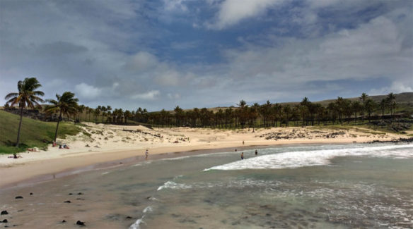
The volcanic rocks are resistant, but fine-grained and lacking sand-sized or coarser particles of resistant minerals that form sandy beaches. So boulders dominate what we think of as the ‘beach zone’ (Figure 4), and green or black sand beaches like those in Hawai’i are absent. There is some growth of reef-associated organisms that provide carbonate skeletal sand-sized material for the island’s very scarce sand beaches. These occur as pocket beaches in wave-eroded embayments, washed by shallow turquoise waters. Only three sandy beaches can be found on the island: Anakena Beach and Ovahe Beach, both located on the north side, and Pea Beach, in Hanga Roa. Pea Beach is of such small size that it’s of little note here.
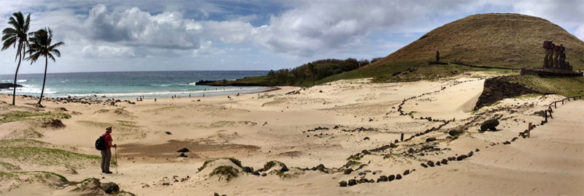
Figure 11. Anakena Beach is a beautiful pocket beach of carbonate sand. Two archaeologic features, Ahu Ature Huki (the lone moai statue in background), and the Ahu Nau Nau (seven moai on right), add to the mystic of beach. The stones mark off the ‘sacred area’ around the monuments.
Anakena Beach:
If you are looking for a world-class ‘perfect’ beach this is the place (Figure 11). The pocket beach is located in a short embayment, and is composed of white and delicate coral sand washed by crystalline turquoise waters, and surrounded by coconut palms imported from Tahiti (Figure 12). The pattern of inland sand transport, a barren flat, and small dune features, give evidence of occasional strong onshore winds. In addition to being an idyllic beach, this is the cradle of origin for the Rapa Nui people. According to legend, their history began in this place with the arrival of the first king of the island, Ariki Hotu Matu’a. At the back of the beach are two ceremonial platforms, the Ahu Ature Huki (a single moai statue, first to be raised on the island in modern times), and the Ahu Nau Nau (a platform composed by seven moai, Figure 11). The beach is flanked by two cinder cones to the East which are part of a headland, separating it from Ovahe Beach.
Ovahe Beach:
This smaller pocket beach to the east of Anakena, across the wide volcanic headland (with the two cinder cones) is of similar sand composition, but stands in contrast in that it is ringed in by a semicircle of sea cliffs. The cliffs result in more difficult access to the beach, and are a hazard in terms of falling rocks. A line of boulders crossing the beach should suggest to the beach goer to be wary of possible falling rocks.
Biota
This isolated island’s climate is typical of a tropical rainforest, but sometimes changing to a humid subtropical climate due to rains that average 1,100 mm per year. The geographic location allows winds to keep temperatures between a 15 C° avg. in July-August (coldest season) to 29°C in February (summer season). Because the island is near the South Pacific High and outside the range of the intertropical convergence zone, cyclones and hurricanes do not occur, but rainstorms and heavy rainfall occasionally strike the island.
Botanical studies define the Eastern Island as a paleo-subtropical broadleaf forest. The above classification is because fossil records of tree molds (in lava flows), fossil pollen, and root casts found along with the soils, indicate that in the past the entire island was formerly forested with a range of trees, ferns, shrubs, and grasses. For example, the Paschalococos disperta, an extinct palm, was one of the dominant trees as attested by fossil evidence. Upon the European arrival to the island, the endemic toromiro tree was the only wild tree, and the Carolina wolfberry the lone native shrub; the vegetation being predominantly herbaceous. Island wood carvers overexploited the toromiro tree, and the last local specimen died in the 1950s. Today 31 wild flowering plants, 14 ferns, and 14 mosses are reported. Grass and small ferns dominate the volcanic landscape, whereas lakes are thickly covered by two imported American species, the totora reed and Polygonum acuminatum (a medicinal plant). Currently, trees are sparse, rarely forming natural groves, and, as noted above, it has been argued that local Easter Islanders deforested the island in the process of erecting moai, and in providing sustenance for an overpopulated island.
In the past, island animal life was restricted to a very few species of isopods, spiders, insects, worms, and snails. Rats probably arrived with the pioneer Polynesians, and later could have contributed to the collapse of the ecosystem. Sheep, horses, cattle, and pigs were introduced by colonies of missionaries who established themselves on the island in 1865, and remain the dominant animals today.
Marine life of the clear turquoise waters is dominated by crayfish, sea turtles and various coastal fishes that abound around the entire coast, and are popular with divers and snorkelers. All of these features provide for activities that include beachcombing, snorkeling, diving, and surfing; a perfect place to commune with Nature.
The Travel Ideal?
Easter Island has to rank high on anyone’s travel ‘bucket list’ simply for the amazing archaeology. But the palate of beauty, both landward and seaward of the shore, makes Te Pito o Te Henua Island an experience unique in the world. Anakena Beach, as small as it is, ranks in the top 10 on our list. All across the island, hiking trails provide access to breathing fresh air, exploring Nature’s wonders of volcanoes and rocky shores, and visiting the amazing archeological wonders of the Rapa Nui people. And remoteness and lack of high-rise tourism favors night-sky watchers.
Water enthusiasts will find opportunities for surfing, and the island is a perfect place for diving activities because the waters are clear and transparent (visibility can reach up to 70 meters), with temperatures of 18 to 26 C°, that make the diving experience unforgettable. (Note: Dive and see the moai on the ocean bottom in Hanga Roa Bay for a wonderful experience).
Nine coastal sites to visit around the island
- Rano Kau Volcano and the Orongo Village: The Rano Kau is a 330 m high, extinct volcano that forms the southwestern headland of the Easter Island. The Crater Lake is one of the island’s only three natural bodies of fresh water (Figure 3). The ceremonial village of Orongo is located at the point where the inner crater wall converges with the sea cliff (Figure 13). In the past, Orongo was the center of a birdman cult whose defining ritual was an annual race to bring the first manutara (sooty tern) egg back undamaged from the nearby stack of Motu Nui to Orongo (Figure 6).
- Ana Kai:
- Hanga Piko:
- Tahai:
- Hanga Kioe:
- Ana Kakenga:
- Ahu Te Peu:
- Anakena:
- Ahu Tongariki:
This coastal site is located just south of Hanga Roa (the town), not far from the road to Ranu Kau volcano. Ana Kai or “the cave of the cannibals” is on a terrific coastal landscape composed of black cliffs, and the cave is decorated with Rapa Nui paintings (Figure 9). Currently, the cave entrance is closed due to falling rocks. However, the coastal scenery is stunning.
“Anakena Beach is a beautiful pocket beach of carbonate sand. Two archaeologic features, Ahu Ature Huki (the lone moai statue in background), and the Ahu Nau Nau (seven moai on right), add to the mystic of beach… ”
— N.Rangel-Buitrago, A. Gracia & W. Neal
This may be one of the most exotic harbors in the world. Hanga Piko means “Hidden Bay,” and inside this port is a ceremonial complex consisting of the Ahu Ataranga, the Ahu Ana Hoto Huero and the Ahu Riata platforms (Figure 14). Due to its excellent access to the sea and its anchorage conditions, this area is the most prominent harbor of the entire island and gives shelter to different marine activities.
This ceremonial complex is said to be one of the best places in the world to watch the sunset. The compound comprises three principal ahu: Ko Te Riku, Tahai, and Vai Ure (Figure 7). The tomb of William Mulloy, the famous anthropologist who came to the island with the Thor Heyerdahl expedition in 1955, is located in the south of this complex.
This site consists of a coastal esplanade with two moais: the Ahu Akapu and the Ahu Hanga Kio’e. Inside this complex is a square, a hare moa (chicken coop), and also several remains of hare paenga (boathouses), which were part of the ceremonial center (Figure 8). Hanga Kioe means “Bay of the Mouse.” This name comes from an old Rapa Nui legend about a widow who entered this place with a mouse in her mouth, in mourning for the death of her husband, whose remains were buried here after the ceremonial platform was built.
Ana Kakenga, or the cave of the two windows, is perhaps the most beautiful cave on the island. This volcanic tube, about 50 meters long, was used as a refuge cave during the struggles that took place between the different clans of the island. If you aren’t claustrophobic, the only available access can be found camouflaged in the grounds; a small hole, slightly more than half a meter wide. A short walk in the cave leads to two natural windows, situated 30 meters high on the face of the volcanic cliff where the lava tube exited towards the sea. These windows provide a terrific view of the nearby islets, called Motu Ko Hepoko and Motu Tautara (Figure 10). For non-cavers, this fantastic scenery can be seen from along the face of the sea cliff (Figure 4).
Ahu Te Peu is the gate to the island’s untamed northern coast. This separate cliffed area remains almost untouched since it is less visited by tourists. The megalithic complex has several fallen moai and a village site with foundations of hare paenga (elliptical houses), and the walls of several round dwellings consisting of loosely piled stones (Figure 5). Here you can feel the isolation of the island from the world, and breathe clean air while listing to the waves crashing on the cliffs. Ahu Te Peu is among the most peaceful places in the world.
Similarly, Anakena Beach is a peaceful place and, as noted above, a world class beach (Figures 11 and 12). Offshore reef organisms are the source for the sand-sized fragments of coralline and other calcium-carbonate skeletal material that makes up the beach. The archaeologic sites, cinder cones, nearby Ovahe Beach, and rocky-shore features all add to the attraction of this site.
In fact, most of the sites noted here have multiple attractions, and this is again true for Ahu Tongariki. The combination of the Rano Ranaku Volcano, sea cliffs, stacks, turquoise water, and 15 impressive moai statues is more than unique, and it’s difficult to find sufficient adjectives to describe the beauty of this coastal site (Figure 2). This place was the sociopolitical and religious center of the Hotu Iti, one of the two great clans that grouped the tribes of the eastern sector of the island. This family left, as a legacy, one of most massive ceremonial structures built on the island and the most important megalithic monument in all of the Polynesia region. The times of the “summer solstice” (December 21st) and “autumn equinox” (March 21st) are ideal for observing the sunrise in this place, when the sun-rise through the back of the moai gives a spectacular, unforgettable image.
Trouble in Paradise
Not all is perfect in Eden! Once again the island is threatened by population growth. Significant numbers of tourists, plus immigrants from mainland Chile, and reliance on a tourism economy that encourages more development and heavier use of infrastructure are straining the island’s resource management, including adequate safe water supply and waste processing facilities. In particular, Litter is a big issue for the island. These critical problems currently are threatening all world coastal environments, but are more obvious in island environments. Unfortunately, Easter Island is no exception as 20 tons of litter are produced daily. As an indication of the scale of the solid-waste problem, the recycling plant, that opened 17 years ago, processes at least 41,000 plastic bottles every month. In the same way, the island is an example of how humans can impact an area without even being there. Significant amounts of refuse, especially plastics and microplastics, arrive every day on this beautiful coast (Figure 15).
Te Pito o Te Henua Island is undoubtedly one of the wonders of the world. The people, the scenery, and the stunning moai, standing on their stone plinths are unique. But it is clear, this island has issues to solve. If these problems are unaddressed, they could eventually damage the present and future of one of the most singular places on the planet. This island’s ecosystem and population crashed in the past – its history provides both a lesson and a warning.


