Mauritania. Photo source: ©© John Spooner
By NASA,
NASA’s 2013 Hurricane and Severe Storms Sentinel or HS3 mission will investigate whether Saharan dust and its associated warm and dry air, known as the Saharan Air Layer or SAL, favors or suppresses the development of tropical cyclones in the Atlantic Ocean. The effects of Saharan dust on tropical cyclones is a controversial area of science. During the 2012 campaign, NASA’s Global Hawk unmanned aircraft gathered valuable data on the dust layer that swirled around Tropical Storm Nadine for several days.
The Saharan dust layer is composed of sand and other mineral particles that are swept up in air currents and whisked westward over the Atlantic Ocean. The extreme daytime heating of the Sahara creates instability in the lowest layer of the atmosphere, warming and drying the air near the surface and cooling and moistening the air near the top of the dust layer near 5 kilometers (16,500 feet). Once it exits the African coast, the dust-laden air moves over air that is cooler, and moister, and it’s the temperature inversion of warm air over cold that prevents deep cloud development. This suppression of deep cloud formation along with the dry air within the dust layer is reasons why this Saharan air layer is sometimes thought to suppress tropical cyclone development. On the other hand, the southern boundary of this hot desert air essentially acts like a front whose attendant wind patterns are a major source of the African waves that are precursors to storm formation.
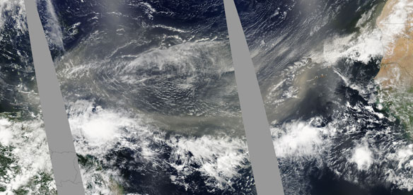
A well-defined plume of dust swept across the entire Atlantic Ocean on June 24, 2009. In this photo-like image taken by the Moderate Resolution Imaging Spectroradiometer (MODIS) on NASA’s Aqua satellite in three consecutive overpasses, the dust stretches from its origins in Africa’s Sahara Desert to the Lesser Antilles Islands on the eastern edge of the Caribbean Sea. Such spectacular dust storms are not uncommon. Credit: NASA image by Jeff Schmaltz, MODIS Rapid Response. Caption by Michon Scott and Holli Riebeek with information provided by William Lau, NASA Goddard Space Flight Center.
Some Saharan dust has been known to make the journey across the Atlantic and to the U.S. east coast. But Saharan dust doesn’t just cause sunrises to appear more reddish, the dust also impacts the development of clouds and precipitation. The dust particles can provide a surface for small cloud droplets and ice crystals to form within clouds. More dust particles means that a given amount of available water is spread onto more particles, creating large numbers of small drops and delaying the formation of larger raindrops. Those effects, coupled with the warm and dry air, have presented challenges to meteorologists who have been trying to understand the effect of Saharan dust on tropical cyclones.
HS3 addresses the controversial role of the Saharan Air Layer, or SAL, in tropical storm formation and intensification by taking measurements from three instruments on board the Global Hawk. These instruments include a cloud physics lidar which uses a laser to measure vertical profiles of dust; a dropsonde system that releases small instrumented packages from the aircraft that fall to the surface while measuring profiles of temperature, humidity, and winds; and an infrared sounder that measures temperature and humidity in clear-sky regions.
On Sept. 11 and 12, during the 2012 HS3 mission, the NASA Global Hawk aircraft covered more than one million square kilometers (386,100 square miles) going back and forth over the storm in a gridded fashion in what’s called a “lawnmower pattern.”
The SAL was present primarily during that first flight, and again on the flight from Sept. 14 to 15. “The SAL did not act to suppress development on Sept. 11 and 12, at least not in the sense of a direct intrusion into the storm circulation, but it is too early to say what role it might have played in other ways and in other flights,” said Scott Braun, HS3 Principal Investigator, at NASA’s Goddard Space Flight Center, Greenbelt, Md. “There is some evidence that it (the SAL) was getting into the storm circulation on Sept. 14 and 15, but the extent to which it impacted development is unclear.”
The dust data collected by the Global Hawk is important for scientific studies on the SAL. Other data was useful operationally to the National Hurricane Center (NHC), the entity that issues forecasts for tropical cyclones. The forecasters at the NHC used data from dropsondes released from the Global Hawk in the discussion of Nadine at 11 a.m. EDT on Sept. 20, “The current intensity is kept at 45 knots (51.7 mph/83.3 kmh)…is in good agreement with dropsonde data from the NASA global hawk aircraft and AMSU [satellite instrument] estimates.”
Valuable data from the Global Hawk dropsondes on September 22-23 provided the National Hurricane Center with information that contributed to their reclassifying the storm as a tropical storm after one day of being called a post-tropical low. Shortly after HS3’s last flight into Nadine on September 26-27, Nadine actually strengthened back into a hurricane and reached its maximum intensity.
Dropsonde data from HS3’s flight on September 26-27 showed that temperature and humidity conditions in the storm were becoming more favorable for the occurrence of deep thunderstorms. Infrared data from NASA’s Aqua satellite on Sept. 28, 2012, revealed that strong convection and thunderstorms did build up again and strengthened Nadine back into a hurricane.
HS3 is a five-year mission specifically targeted to investigate the processes that underlie hurricane formation and intensity change in the Atlantic Ocean basin.
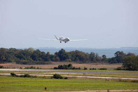
The Global Hawk unmanned aircraft coming in for a landing at NASA’s Wallops Flight Facility in Wallops Island, Va on Sept. 7, 2012. Credit: NASA Wallops.

