Authors:
William J. Neal and Benjamin S. Burroughs, Geology Dept., Grand Valley State University, Allendale, MI, and Marguerite A. Hertstein, Grand Rapids, MI
The book, Vanishing Sands (Pilkey et al., 2022), examined global beach losses due to direct mining of beaches and other sources of beach sand (e.g., rivers, dunes). However, natural beaches can be lost from having gained sediments as the result of mining operations. Such is the case of mining impacts in the form of stamp-sand beaches on Michigan’s Keweenaw Peninsula shores and shallows of Lake Superior (Figures 1 and 2).
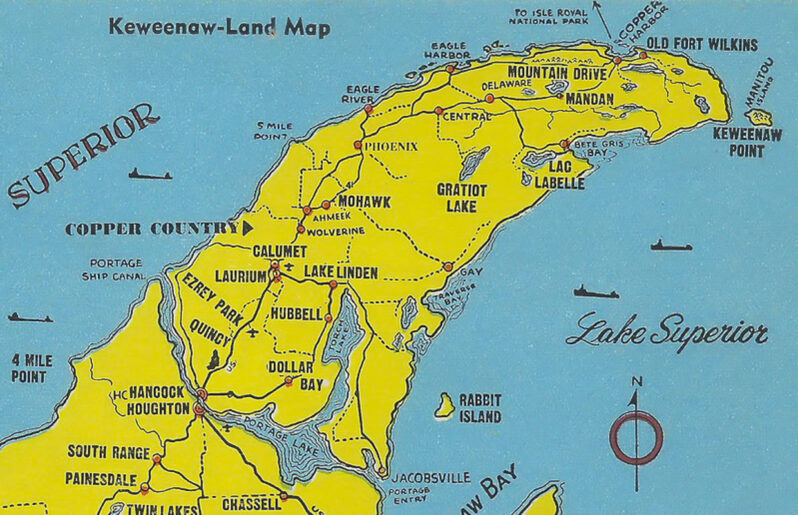
Figure 1. Index Map (after Kerfoot et al. 2004, 2019, 2021) of Keweenaw Peninsula that juts out into southern Lake Superior (Inset). The region was subject to intensive mining of copper and other metal ores in the 19th and 20th centuries from the zones of Precambrian meta-igneous and sedimentary rocks (e.g., the ore-bearing Portage Lake Volcanics). Initial processing of the ores was in stamp mills (stars) located next to inland waters (e.g., Portage Lake, Keweenaw Waterway, Torch Lake), and at three locations on the Lake Superior shore: Gay the focus of this paper (color-shaded area of Big Traverse Bay with coastal stamp-sand accumulation through time); Freda/Redridge on the NE shore; and Mass Mill near Baraga at the SE shore of Keweenaw Bay (SE corner of Peninsula on Inset – no star). Kerfoot et al. (2004) studies of sediment cores from Lake Superior show widespread copper concentration (contours) with high concentrations of 200—400 g cm-2 shown at black squares.
Figure 2. 1985 Google Earth image of the Gay mills stamp sand coastal deposit (gray unvegetated zone) extending from north of the village of Gay (upper right; mills site) to the Traverse River jetties at Traverse Bay village (lower left); a shoreline distance of over 5 miles. The large pond midway between Gay and the river jetties is the old Coal Dock site. The dominant subaerial deposit formed by sediment being carried from NE to SW and appears to terminate against the river’s north jetty. However, huge amounts of this waste material are deposited on the nearshore lake bottom, and the eroded suspended silts and clays are carried far offshore (e.g., greenish-blue zone along wider part of deposit and plume extending lakeward).
Copper deposits in the Keweenaw Peninsula have been utilized/mined for an 8000-year time span from Indigenous Peoples to 18th century European exploration (NPS, 2025), the first mine in 1771, and to the “Age of Copper” in the 19th and 20th centuries when the Michigan copper boom reached its peak. The number of mines (Figure 1) and boomtowns rapidly increased as did the number of stamp mills to crush ore and recover the copper, and in some cases silver. The Keweenaw region’s copper ores were from zones of Precambrian metamorphosed igneous and sedimentary rocks (e.g., ore-bearing Portage Lake Volcanics; Calumet Conglomerate). Ores were processed in stamp mills to recover the native copper or copper-bearing minerals for shipment to smelters. These mills were located next to the shores and shallows of inland waters (e.g., Portage Lake, Keweenaw Waterway, Torch Lake) as well as Lake Superior for processing water supply and for disposal of the tons of waste sediments (dumps of convenience) generated by the rock crushing. Three major mill sites located on the Lake Superior shore were the Champion Mill in the Freda/Redridge area (1903 to 1967), the Mass Mill at the south end of Keweenaw Bay (1902 to 1919), and the Mohawk (1902 to 1932) and Wolverine (1902 to 1925) Mills at Gay, Michigan (Figure 1).
The Gay site and impacted area have been dubbed a “$1billion eco-disaster” (Ellison, 2022) and is the focus of this photo essay on how a natural beach was turned into a zombie beach (Figure 2). Here the “stamp sands” were deposited directly onto the beach and into the nearshore waters, setting off a century-long cascade of environmental destruction. While the environmental impacts are varied and spectacular, we were drawn to reviewing mainly the impact on the natural beach, visiting the site in 2023 and 2024 to specifically collect natural beach sands south of the river jetties (Figure 2) and at the source near Gay (Figure 3). Although these deposits are referred to as “stamp sands,” the actual grain sizes range from small pebbles through sand to silt and clay (Figure 4).
Figure 3. Stamp sands sample collection locations at the Gay former mills site. GSS1 and 2 were from the beach area for composition and grain size/sorting analysis. GSS3 and GSS4 from areas subject to wind-blown size-sorting and composition (e.g., GSS4 from wind deposit in wind-shadow of fallen log). GSS5 is from the coarser sediment clasts found in the back beach area, commonly used currently for off-road vehicle recreation (ATV’s, motorbikes, etc.). This image also provides a good perspective on the submerged concrete sections of the sluice flume that have fallen into the lake as erosion removed the supporting base of accumulated stamp sands. The line of exhumed support posts marks the former path of one of the conveyor systems.
Figure 4. Surface of the stamp sand deposit. Note that much of the sediment appears coarser than “sand” (granule size), but there are significant amounts of sand, silt and clay. Portions of the tailings pile have a slightly purplish color which Kerfoot et al. (2012) attribute to the iron-oxidized clay fraction. [Penny for scale]
History of Mohawk/Wolverine Mills and Dead Beach Legacy
In 1899 the Mohawk Mining Co. located the initial mine. Construction of the Mohawk Mill began a year later and went into production in late 1901, continuing until closure in 1933. The Wolverine Mill began production at about the same time but closed in 1926. By 1902 stamp sand disposal at Gay was underway at both mills…
Sand Tales Story 2: The Lost Coral
CURRENT NEWS + RECENT POSTS