A ‘super typhoon’ just devastated the Mariana Islands, months before peak storm season – Grist
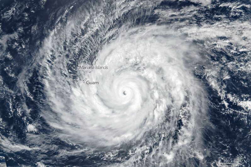
The storm exposes the U.S. commonwealth’s climate risks, economic fragility, and federal strain…
Dozens Rescued in Remote Alaskan Villages in Storm That Swept Away Homes – the New York Times

The Coast Guard and the Alaska National Guard were conducting search-and-rescue operations in two villages along the Bering Sea on Sunday….
Minecraft game launched to teach climate change – BBC

A customised version of Minecraft is being used to inspire children to learn more about climate change…
They survived Hurricane Helene. Here’s how they’re doing a year later – Grist

The powerful storm caught many people off guard as it drove through six states. As devastating as it was, did Helene truly change anything?…
Stinson underwater, Ocean Beach halved: California’s beach reckoning is here – SF Gate

California’s most iconic feature is disappearing…
Disaster 101 – Grist

Your guide to extreme weather preparation, relief, and recovery..
Sea Level Rise Adaptation Will Cost Over $1 Billion At A Marin County Beach – San Raphael Patch

A recent report stated the projects needed to protect a popular beach will cost an estimated $1.2 billion…
The future stewards of the Venice Lagoon – Oceanographic

Aligned with the UN Decade of Ocean Science, the Kindergarden of the Lagoon initiative – a part of Prada Group and UNESCO’s Sea Beyond campaign – aims to spark a worldwide movement supporting ocean preservation, starting with Venice’s youngest members of society….
Ghana’s vanishing coast: Climate change is eroding historic site – France 24

In the Ghanaian city of Keta, a key part of the country’s history there is under threat from climate change. Fort Prinz en-stein, which was once a grim clog in the transatlantic slave trade, is now a shell of itself because of rising seas levels, relentless erosion and human neglect. Activists are now urging the government to act fast to preserve the UNESCO world heritage site…