The way of water: Can anything be done to save our disappearing beaches? – WA Today

South Beach is a far cry from those wide-open ultra-Aussie surf destinations such as Scarborough and Trigg (the bit in front of Wilson Park is barely a kilometre long)…So you can imagine my shock when I recently popped down for a jog and a swim to discover that a good chunk of the white stuff that was so fundamental to my experience of Fremantle had disappeared…
Beach Houses Around the Country Are at Risk of Sinking, and Coastal Enclaves Are at War About How to Save Them – Robb Report

For some homebuyers, the fantasy of coastal living will forever outweigh the risks. But rising sea levels and shifting sands can mean getting closer to the ocean than you might have intended.
It was after a beachside housewarming party in Southern California that the neighborhood snitch was unmasked…
In pictures: France demolishes beach apartments and relocates residents due to rising sea levels – Euronews | Reuters

When it was built at the end of the 1960s on one of France’s most glorious Atlantic coastlines, the beach was over 200 metres away.
Today, the hulk of the 80-flat Le Signal apartment block perches precariously on a dune just metres from the water and local authorities are tearing it down before it tumbles…
Beach erosion: Satellites reveal how climate cycles impact coastlines – UNSW Sydney

New research shows coastlines across the Pacific Ocean may respond differently to El Niño and La Niña cycles.
Researchers from UNSW Sydney have analyzed millions of satellite photos to observe changes in beaches across the Pacific Ocean. The findings, published in Nature Geoscience today (Feb. 10), reveal for the first time how coastlines respond to different phases of the El-Niño-Southern Oscillation (ENSO) cycle…
Frustrated landowners push back against state’s ‘managed retreat’ approach to rising seas – Hawaii News Now

Citing advances in erosion control technologies, a coalition of oceanfront property owners are urging the state to give them more weapons in their battle against beach erosion…
But state officials and climate change experts said barriers such as sea walls will destroy the state’s beaches…
Coastal residents fear ‘hideous’ seawalls will block waterfront views – the Guardian

There were more than a few issues with a recent federal plan to wall Miami off from the dangers of climate change.
The $5bn proposal involved building a massive concrete seawall in the fragile marine ecosystem of Biscayne Bay. It included using taxpayer money to elevate private waterfront mansions, while constructing a wall through the middle of downtown and sometimes low-income neighborhoods…
USGS Remote Sensing Data Tracks Coastal Erosion from California Storms – USGS

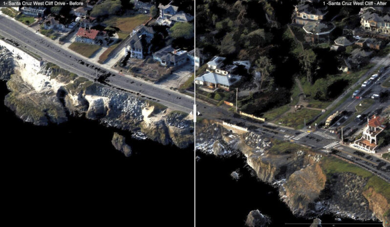
The USGS has collected and released topographic data that show the erosional effects of the January 2023 storms on the coast for the Santa Cruz region of California…Comparing the data with pre-storm conditions mapped in September 2022 provide “before” and “after” perspectives of the effects of the January storms. These data have been released under USGS Emergency Use Data authorities for data that have immediate or time-sensitive relevance to public health and safety…
