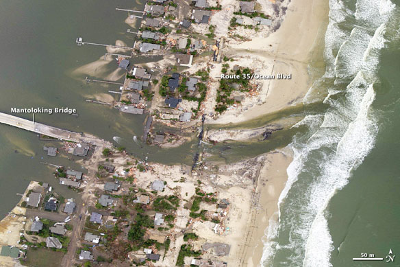

These photographs show a portion of the New Jersey coastal town of Mantoloking, just north of where Hurricane Sandy made landfall.

By Mike Carlowicz / NASA;
On October 29, 2012, lives were changed forever along the shores of New Jersey, New York, Connecticut, and in the two dozen United States affected by what meteorologists are calling Superstorm Sandy.
The landscape of the East Coast was also changed, though no geologist would ever use the word “forever” when referring to the shape of a barrier island.
The two aerial photographs above show a portion of the New Jersey coastal town of Mantoloking, just north of where Hurricane Sandy made landfall.
The top photograph was taken by the Remote Sensing Division of the National Oceanic and Atmospheric Administration (NOAA) on October 31, 2012; the lower image was acquired by the same group on March 18, 2007. The images were acquired from an altitude of roughly 7,500 feet, using a Trimble Digital Sensor System.
The Mantoloking Bridge cost roughly $25 million when it was opened in 2005 to replace a bridge built in 1938. After Sandy passed through on October 29, 2012, the bridge was covered in water, sand, and debris from houses; county officials closed it because they considered it unstable.
On the barrier island, entire blocks of houses along Route 35 (also called Ocean Boulevard) were damaged or completely washed away by the storm surge and wind. Fires raged in the town from natural gas lines that had ruptured and ignited. A new inlet was cut across the island, connected the Atlantic Ocean and the Jones Tide Pond.
Coastal Change Hazards: Hurricanes and Extreme Storms, USGS
Hurricane Sandy made landfall along the coast of southern New Jersey on Monday, Oct. 29th. Elevated water levels and powerful waves associated with the storm led to wide-spread beach and dune erosion along much of the U.S. Eastern Seaboard. Prior to landfall, USGS scientists used modeled storm surge and wave conditions and observations of beach and dune elevations to determine what types of coastal change might be expected during landfall.
Updated Assessment of Potential Coastal-Change Impacts, USGS
USGS has developed a storm-impact scale that predicts the likelihood of coastal change by comparing modeled elevations of storm-induced water levels to known elevations of coastal topography in order to define three coastal change regimes. These regimes describe how beach morphology (physical form) and storm processes tend to interact, and the resulting modes of coastal change along beaches and dunes, which often serve as the “first line of defense” for many coasts exposed to tropical storms and hurricanes.


