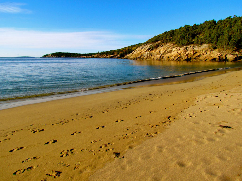

Acadia National Park. Photo source: ©© Jeff Gunn
By Mike Carlowicz, NASA / Earth Observatory;
It has had many different names: Pemetic. Isles des Monts Déserts. Sieur de Monts National Monument. Lafayette National Park.
It has had several superlatives: First national park east of the Mississippi River. Highest mountain along the U.S. East Coast. First place you can spot the sunrise in the United States.
It has been settled and re-settled by at least three different cultures—the Wabanaki, the French, the English—and drawn fishermen, farmers, artists, and the upper crust of late Victorian America—the Rockefellers, Morgans, Fords, Vanderbilts, Carnegies, and Astors.
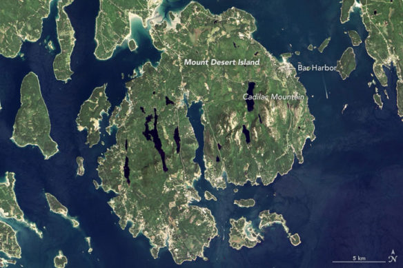
Today, Acadia National Park is one of the most visited parks in America, drawing more than 2.5 million visitors per year to the craggy, jagged coast of Maine. The park is celebrating its 100th anniversary in 2016. On September 6, 2015, the Operational Land Imager (OLI) on the Landsat 8 satellite acquired these images of Acadia National Park and its surroundings.
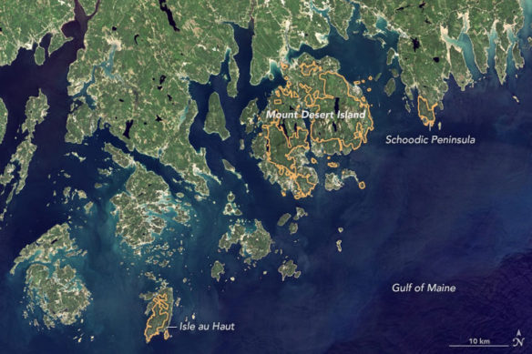
Mountains and hills roll right up to the Atlantic Ocean in this rocky landscape carved by glaciers at the end of the last Ice Age. Since the beginning of the 20th Century, the park has been pieced together by donations and acquisitions of once-private lands, and it is still growing. Of the park’s 47,000 acres, more than 12,000 are privately owned lands under conservation agreements, while the rest is held by the National Park Service. Mount Desert Island is the focal point of the park, which also includes lands around a former naval base (Schoodic Peninsula), Isle au Haut, and several smaller islands.
Mount Desert Island is the largest in Maine and the second largest on the East Coast. “It looks like a big lobster claw,” said Lynne Dominy, chief park ranger for interpretation at Acadia. “It’s both ironic and iconic, as we are surrounded by lobsters living in the Gulf of Maine.”
Writing in his journal after landing on the island in September 1604, Samuel de Champlain noted: “The mountain summits are all bare and rocky…I name it Isles des Monts Déserts” (French for “the island of barren mountains.”). Cadillac Mountain is the highlight, standing as the highest point (1,528 feet or 470 meters) within 25 miles (40 kilometers) of the Atlantic Ocean. Because its elevation and its far eastern location, it is claimed to be the first place an American can see the sunrise.
“Mount Desert is covered with forests, mountain summits, and freshwater lakes,” Dominy added. “This topography enables visitors to experience many wonderful things while visiting this island: walking on beautiful rocky shorelines; sailing offshore on boats; hiking on lush forest trails; climbing bald granite summits; and paddling on crystal clear lakes.”
Efforts to preserve Acadia began around 1901, led by conservationist George Dorr, who began cobbling together acquisitions and donations of land. Dorr and the Hancock County Trustees of Public Reservations turned over 6,000 acres to the U.S. government, with President Woodrow Wilson creating Sieur de Monts National Monument in 1916. In 1919, the parcels of the Maine coast were desginated Lafayette National Park in honor of the Marquis de Lafayette.
In 1929, the name was changed to Acadia, recalling the name of the original French colony in the region. Due to the public-private nature of the land holdings, it was not until 1986 that the U.S. Congress finally established official borders for the park. You can see the evolution of those land holding in the video at the bottom of this page.