Icebergs along Princess Ragnhild Coast, Antarctica: NASA Earth Observatory
By Michon Scott, based on image interpretation by Ted Scambos, National Snow and Ice Data Center

NASA Earth Observatory image created by Jesse Allen
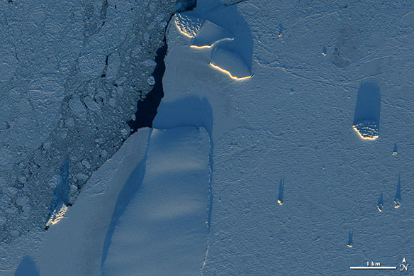
Each December, while darkness engulfs the Arctic, Antarctica enjoys round-the-clock sunlight. The light arrives at a low angle, however, as the Sun makes a daily circuit around the horizon, and icebergs cast long shadows over the surrounding sea ice.
Acquired on December 13, 2010, this image from the Advanced Land Imager (ALI) on NASA’s Earth Observing-1 (EO-1) satellite shows icebergs along the Princess Ragnhild Coast in East Antarctica. Besides distinguishing between icebergs and thinner ice, the low-angled Sun highlights the differences between the icebergs themselves.
Near the top center of the image, two large icebergs sport smooth surfaces. The iceberg next to them, and others along the left and right edges of the image, have mottled surfaces resembling druzy. The differences in texture indicate different histories. The icebergs with rough surfaces likely broke off from the coast, far from this area, and spent time bobbing over the open ocean. Wave action applied pressure to the bottoms and sides, and the pressure propagated up through the ice to the surface. Weak spots fractured, and bits of snow and ice fell into the cracks, widening them further. The icebergs you see above likely bear scars from such jostling. By contrast, smooth icebergs likely originated in this area and have not yet traveled far.
Surrounding the icebergs are two kinds of ice: sea ice and fast ice. Along the left edge of the image, the sea ice is thinner, with gaps that reveal the dark ocean below. Clinging to the shore, fast ice is thicker, although not nearly as thick as the icebergs.
Stirring Up a Bloom off Patagonia: NASA Earth Observatory
By Michael Carlowicz, NASA Earth Observatory

NASA Image created by Norman Kuring, Ocean Color Web
The most interesting art often arises from the convergence of different ideas and influences. And so it is with nature sometimes.
Off the coast of Argentina, two strong ocean currents recently stirred up a colorful brew of floating nutrients and microscopic plant life just in time for the summer solstice.
The Moderate Resolution Imaging Spectroradiometer (MODIS) on NASA’s Aqua satellite captured this image of a massive phytoplankton bloom off of the Atlantic coast of Patagonia on December 21, 2010. Scientists used seven separate different spectral bands to highlight the differences in the plankton communities across this swath of ocean.
The milky green and blue bloom developed in an area known as the Brazil-Falklands Confluence. It’s where the warm salty waters of the subtropical Brazil Current flow south and meet the colder, fresher waters brought north from the Southern Ocean by the Falklands (Malvinas) Current. Where these currents collide along the continental shelf, known to oceanographers as a shelf-break front, turbulent eddies form and pull nutrients up from the deep ocean. Also, the Rio de la Plata runs off the land and deposits nitrogen and iron-laden sediment into the ocean just north of the area shown in the image.
Add in some strong summer sun, and you have a bountiful feast for the microscopic, floating plants, phytoplankton, that form the center of the ocean food web. Those plants become food for everything from microscopic animals (zooplankton) to fish to whales.
Though it is impossible to say for sure without direct sampling of the water, most of the phytoplankton blooming in this photo are likely coccolithophores, single-celled plants that form calcite scales. (Calcite is a carbonate mineral often found in limestone chalk.) Blooms of coccolithophores are common in those waters in southern hemisphere’s spring and summer. Diatoms might also be in the mix.