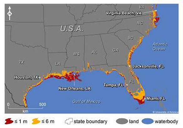

This map shows where increases in sea level could affect the southern and Gulf coasts of the US. The colors indicate areas along the coast that are elevations of 1 meter or less (russet) or 6 meters or less (yellow) and have connectivity to the sea. Caption and Photo Source: Jeremy Weiss, University of Arizona
Excerpts;
Rising sea levels could threaten an average of 9 percent of the land within 180 U.S. coastal cities by 2100, according to new research led by University of Arizona scientists.
The Gulf and southern Atlantic coasts could be particularly hard hit. Miami, New Orleans, Tampa, Fla., and Virginia Beach, Va. could lose more than 10 percent of their land area by 2100.
The research is the first analysis of vulnerability to sea-level rise that includes every U.S. coastal city in the lower 48 with a population of 50,000 or more.
The latest scientific projections indicate that by 2100, the sea level will rise about 1 meter – or even more. One meter is about 3 feet.
At the current rate of global warming, sea level is projected to continue rising after 2100 by as much as 1 meter per century…


