
Seagull Row. Beach Homes on Seagull Drive in South Nags Head NC on a calm day in March 2011. Caption and photograph by ©Gary Lazorick
By Gary Lazorick
“Men cannot build houses upon sand and expect to see them stand now anymore than they could in the olden times…”
—Raleigh Observer, 1879.
After “Nor-Ida” hit the coast last fall, septic tanks lined South Nags Head’s Sea Gull Lane like tombs in a New Orleans cemetery. Tombs ready to receive the remains of the damaged buildings standing above them after another pounding by storm-driven surf.
Evidence of the power of the sea was all around. Fractured beams, abandoned stairs, tangled wires and gaping PVC pipes jutted beneath each home. Anchor pilings—buttressed by sloppy piles of enormous sandbags—supported each building.
And the sandbag piles, which were originally placed like fortress walls for temporary protection, remain as a disheveled reminder that little can withstand the inevitable power of the sea.
But many developers, homeowners, and local politicians refuse to believe the evidence that the ocean’s transformation of the shore is inevitable. From their perspective, placement of structures on a piece of land fundamentally changes eternal natural laws: sand, and barrier islands, at the coast must move.
For more than a quarter century, North Carolina’s coastal policy has mostly favored the protection of such natural processes over economic interests and investments. That protection, in the form of a comprehensive ban on man-made structures like seawalls, jetties and breakwaters, has been at odds with development interests all along.
Those interests have fought the restrictions of the ban since its inception. Their efforts have resulted in millions of dollars in costs, endless hearings to discuss solutions to the problem and legislative exceptions to the hardened-structure ban.
This spring, development interests and their supporters believed they could tip the balance and place investment above nature in coastal policy. And, as of April 2011, it appears they have.
The North Carolina General Assembly has passed a bill that will forever alter the state’s long-standing ban on construction of hardened erosion control structures. The ban, says East Carolina University coastal geologist Stan Riggs, has been “the envy of coastal scientists and environmentalists nationwide.”
The bill, if signed by Governor Bev Perdue, will authorize the construction of four permanent jetty-like “terminal groins” at coastal inlets, exactly the type of man-made coastal armoring the hardened-structure ban prevented for over twenty-five years.
The bill is the culmination of the ongoing legal and political efforts by monied development interests to get around or exploit weaknesses within the ban, while at the same time exploiting the cooperative sensibilities of the people assigned to apply it.
The gradual efforts of those opposing the ban have had lingering unintended or unforeseen consequences that continue long after seemingly little steps were made. Understanding the true environmental cost of these little steps helps explain why the bill being considered will be, according to Riggs, “the end of the barrier islands” as we know them.
At Stake? Our Beach
Riggs calls the Outer Banks of North Carolina “the highest energy natural zone in the world.” His assertion seems overstated, but he makes a compelling case.
He explains that if you take the relentless wave energy on the coast and add the force of “roughly 35 winter ‘nor-easters’ and 5 to 10 tropical storms” per year, you get a picture of a coastline under siege. In addition, the sea level has been rising for 19,000 years, adding pressure to the system.
That pressure results in the redistribution of sand until a balance is reached. The balance is maintained by barrier islands, like North Carolina’s Outer Banks, through movement or migration towards the mainland. In fact, North Carolina’s barrier islands have migrated more than 60 miles in the last 15,000 years.
Most of us understand the basics of this interplay but misunderstand the speed with which the changes can occur. Our sense of time—a human lifetime is a tiny fraction of the age of the earth—makes it hard to believe the land of the Outer Banks may be ocean in our lifetime. Add the economic distortions of real estate and property rights and the hard to believe is transformed into a belief that coastal erosion can be overcome.
Developers insist that property, certified by deed, deserves to be protected. Structure owners want to enjoy and maintain their investment. Both believe that it makes sense to control erosion by engineering structures designed to protect their property.
But controlling erosion damages beaches. Coastal scientists say the beaches are damaged by structures built near them and endangered by any type of erosion-control structure that interrupts the processes that created them. To scientists, any interruption to natural processes is ultimately harmful.
But too much development has occurred. Processes have already been interrupted. The scientists agree that if action must be taken to counteract erosion, beach nourishment is the preferred method. Nourishment involves replacing the lost sand, in effect rebuilding the beach, at the citizen’s expense.
Development interests argue that nourishment is expensive and must be repeated frequentlybecause the rebuilt beach remains subject to the same erosive forces that removed the sand in the first place. To them a more permanent solution makes more sense.
To the scientists, all permanent erosion-control structures simply move the problem down the beach. Forty-two prominent North Carolina coastal geologists clearly stated their point in an open letter to state legislators in 2006:
“Any coastal structure designed to trap or hold sand in one location will, without question, deprive another area of sand. In simple terms, any structure (including terminal groins) that traps sand will cause erosion elsewhere….”

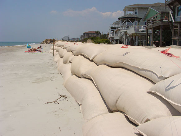
Rows of houses with overlapping sandbag walls create huge problems. The walls do as much damage to the beach as hardened seawalls. Removing the sandbags from one property potentially damages all of the others. Caption and photograph: ©Gary Lazorick
Their point confirms the rationale that was used in 1985 to establish the ban on construction of hardened structures for erosion control. The fact that they felt compelled to write the letter demonstrates how persistent the developers have been at attempting to get jetties and groins built to overcome the erosion threat.
Storms Inhibit Early Coastal Development
Coastal erosion was not noticed, or viewed as problematic for barrier island residents, before the explosion of land development for vacationers in the ’70s. The 1982 book, From Currituck to Calabash, published by the North Carolina Science and Technology Research Center, offers a glimpse into the thinking of early residents and visitors. According to the authors, the few souls until then who chose to live and work in the coastal zone had no misconceptions about the real threat of storms and foolishness of building near open-ocean beaches. Settlements were established on the sound side of barrier islands largely to provide protection from storms. The settlements were subject to far less erosion than the ocean-side beaches that are the focus of development today.
Prior to the ’70s people who visited temporarily for recreation did so mainly to hunt or fish and often wanted access to the beach to pursue their quarry. Their dwellings, however, were built inexpensively for short-term shelter, reflecting the knowledge that making a large investment in the hostile beach environment was a losing proposition.
Coastal storms were a well-known hazard. Their power was feared. Early 1800 transportation improvements, and the recreation potential of the beach, tempted some to establish beach communities. The early resort developments were repeatedly damaged by storms. Some communities, like Diamond City in Carteret County, have been abandoned and long forgotten. A quote attributed to an 1879 editorial from the Raleigh Observer demonstrates the storm-focused criticism of coastal development:
“Men cannot build houses upon sand and expect to see them stand now anymore than they could in the olden times…summer seaside resorts must be built high enough above the tide line to insure safety as well as patronage. People are wary of making hairbreadth escapes in seeking health and rest.”
But improvements in transportation and weather forecasting after World War II allayed the historic fear of storms. Government subsidized insurance softened the potential economic blow. The coastal land rush was on.
By 1979 the new visitors began to notice that the beach, in many places, was moving. The ocean that many wanted to be so close to was getting too close.
A 1981 Coastal Study by the North Carolina Marine Science Council reported that aerial surveys had been conducted since 1968 to assess the growing “problem” of beach recession due to erosion. Thirty-year Dare County Planner and current Kitty Hawk Mayor Ray Sturza recalls Nags Head’s Sea Ranch Hotel as one of the first buildings threatened by erosion in the 1970s. The sea—and not just storms—was making people wary. The calls to “do something” escalated.
The Coastal Resources Commission (CRC), formed in 1974 by the Coastal Area Management Act (CAMA) to manage development on the coast, began to respond by establishing regulations intended to unify what until then had been a largely ad hoc set of rules under a variety of state and local agencies.
First, the commission established and published average annual erosion rates by location along the shoreline. The rates allowed communities to establish coastal development rules that would assure construction “setbacks” that accounted for erosion.
Retired Division of Coastal Management Coastal Hazard Specialist Stephen Benton wrote in a 2009 history of coastal regulations that the rates “provided fair warning of the hazards faced and, therefore, no provisions for oceanfront erosion control structures should be necessary.” The intent of publicizing the rates of erosion was to discourage development in known high-erosion zones and to ensure that all property owners were fully informed of erosion and the risks associated with oceanfront development.
Unfortunately, the warning did little to slow development, even in the most hazardous of areas.
The 1979 regulations, with the fact of erosion declared as a natural process, also established either beach nourishment or the relocation of threatened structures as the preferred methods of erosion response.
Finally, the Coastal Resources Commission declared that only structures built before 1979 could be considered for any other type of permanent engineered protection, since any developers after 1979 were informed of the expected erosion problem.
But by 1984 it was apparent that development had not slowed, and the issue was not always so clear cut. Erosion rates varied widely in different places. Storms created rapid and unexpected changes. Often, development consisted of renovation and repair that muddled established construction dates.
And finally, all owners of threatened structures seemed to believe they had an exception.
The Outer Banks Erosion Task Force was formed to comprehensively examine the variety of ongoing issues and provide a basis for additional rulings as they developed. The task force reported in detail the issues discovered and made extensive recommendations for coastal regulation going forward. Six months of heated debate resulted in the adoption of almost every part of the report as policy.
Current Division of Coastal Management staff indicate that much of the language within the report continues to be used today for decision making. Specifically, in regard to permanent erosion control structures, the CRC policy is to “prohibit sand trapping through the use of groins and breakwaters and shoreline hardening by the construction of breakwaters and seawalls.”
That language, often referred to as the “hardened-structure ban,” or simply “the ban,” is commonly thought of as the basis for CRC decisions. Current CRC Chair Bob Emory adds that in reality four additional principles, used as justification for the ban in the original task force report, form as significant a foundation and basis for decisions. The four principles speak for themselves.
• An ocean beach is a dynamic natural system which includes the nearshore, intertidal, and dry sand/frontal dune area as interrelated components.
• North Carolina’s ocean beaches are subject to constant fluctuation as a result of short-term events (storms), seasonal changes, and long-term erosion, all of which are natural processes.
• The intertidal or wet sand beach is reserved for the use of the public and held in trust for the public by the State. The dry sand beach seaward of the vegetation line has been subject to a long-standing custom of public use and enjoyment.
• An unobstructed public beach is essential to the continued vitality of the tourism industry in coastal North Carolina.
Getting Around “The Ban”
The comprehensive nature of the rule hasn’t deterred distressed homeowners and the communities they live in, however, from trying to get relief from the ban. Everyone’s circumstance is, after all, unique.
The CRC regularly hears petitions for exceptions, or variances, from established rules. All variances are considered against four criteria that must be met collectively:
1. Unnecessary hardships would result from strict application of the rules, standards, or orders.
2. The hardships result from conditions that are peculiar to the property, such as the location, size, or topography of the property.
3. The hardships did not result from actions taken by the petitioner.
4. The requested variance is consistent with the spirit, purpose, and intent of the rules, standards, or orders; will secure public safety and welfare; and will preserve substantial justice.
Significantly, if the four criteria are met, the CRC is compelled to grant the variance.
Potential beach-front petitioners hoping to build a structure to protect their property find few options due to the comprehensive language of the ban. Many property owners also fail to realize that they likely would be unable to meet the first two criteria. The loss of beachfront property is a known potential hazard that is assumed with the decision to build.
The exceptions that have been made are familiar to many Carolinians. Historic Fort Fisher couldn’t be relocated, and beach nourishment wouldn’t help. So it’s protected by a hardened structure.
Few would argue that a historic civil-war-era building doesn’t deserve extraordinary consideration, so an exception allowed the hardened structure to be built.
Another well-publicized exception, made for the Herbert C. Bonner Bridge, is not so clear cut. The bridge spans Oregon Inlet to connect Cape Hatteras with Nags Head. It is not a historic treasure. The decision to allow the construction of a terminal groin at the bridge is part of the continuing controversy surrounding the inlet itself.
The exception was granted to keep the bridge from failing or becoming disconnected from the shore due to the natural process of inlet migration, a process that has been occurring since the inlet was formed in 1846.
Prior to bridge construction, the inlet was known to move, or migrate, up to hundreds of feet per year in response to coastal forces.
The fact of inlet migration raised questions about the wisdom of constructing the bridge from the beginning. A design decision, made to support the local economy, turned the questionable decision into an extremely costly one.
To support local commercial fisherman and prevent traffic delays the bridge was designed with a “high rise span” over the existing navigation channel. That decision has led to endless costly efforts to hold the inlet and its channel exactly in place under the span. The 3,000-foot groin built to protect the Bonner Bridge, and the accelerated erosion the groin has caused, are a result of the bridge design decision.
Those consequences underscore how long-term ramifications and unintended problems often arise from seemingly common-sense decisions. The Bonner Bridge groin—a jetty renamed to avoid the specific exclusion of the hardened structure ban—has accelerated nearby erosion despite annual nourishment efforts involving millions of dollars and cubic yards of sand. Even small-scale decisions like allowing individual property owners to temporarily protect their beach homes with sandbags can have a significant impact.
The Sandbag Nightmare

Photograph by ©Gary Lazorick
When a person purchases beachfront real estate and builds on it, he or she may not fully understand the concept of barrier island migration. Their ability to stand on the property, enter the building and continue to do so year after year creates an indelible sense of permanence. It is understandable that people view the threat from erosion as a personal one and hope to prevent losses by building barriers to protect their property.
It is just as understandable for individuals and lawmakers to provide some relief for the victims of storms. The desire to cooperate and respond to those affected by coastal storms compelled the CRC to soften the comprehensive nature of the ban almost immediately after it was enacted. The CRC decided to allow individual property owners to use sandbags by permit in 1985.
The wording of the exception makes clear the purpose of the decision.
“Temporary measures to counteract erosion, such as beach nourishment, sandbag bulkheads and beach pushing, should be allowed, but only to the extent necessary to protect property for a short period of time until threatened structures may be relocated or until the effects of a short-term erosion event are reversed. In all cases, temporary stabilization measures should be compatible with public use and enjoyment of the beach.”
The intent was to allow temporary protection of a structure until it could be moved or the beach rebuilt through natural or man-made forces. Temporary was not defined or quantified. Strict provisions to maintain the public nature of the beach were written including requirements that the sandbags only be placed parallel to the beach and more than twenty feet above the high tide line.
By 1990, public complaints revealed that sandbags were being placed by homeowners with apparently no intention of removing them. Public beach access was in some instances restricted or blocked by sandbag walls intentionally or unintentionally out of compliance. The CRC added a two- or five-year time limit to the permits that allow structures to be temporarily protected by sandbags.
Controlling erosion damages beaches. To coastal scientists, any interruption to natural processes is ultimately harmful.
—Gary Lazorick
The nightmare created by the sandbag exception had begun. By 1994 some sandbags had been in place eight years and roughly three miles of shoreline were affected by the bags. Threatened enforced removal of the sandbags resulted in successive legislative exemptions from enforcement of permit time limits. First, no sandbags should be removed if they were within a federal disaster area, then bags were allowed to remain if they were located in a community with planned beach nourishment.
By 2000, 236 homes were in violation and subject to enforced sandbag removal. A petition to state legislators by Dare County resulted in a moratorium from enforcement until 2006. The moratorium was then extended to 2008.
In 2008, as the CRC began preparing to enforce the law and require expired or out of compliance sandbags to be removed, new problems became apparent and others became more acute. The now common cycle of beach nourishment on many beaches had buried some of the sandbags. Many of the buried sandbags were under the beach that became public trust as a result of the nourishment. Should they be dug up and removed? Who should pay for the removal?
Some sand bags had worked as intended and protected property until beaches recovered on their own. They were allowed by the permits to remain if they had been covered naturally by sand that supported the growth of dune grass or vegetation. Virtually overnight, lumps of sand began appearing over some sandbags with strips of turf placed on top like a bad toupee. Who determines if sandbags are naturally “covered and vegetated?”
Large sections of shorelines were being eroded resulting in long chains of adjacent properties with overlapping sandbag walls. Each property was typically permitted for sandbags separately. Removing the sandbags from one of these properties would place others at risk. Even those still perfectly legal. Should these be enforced? Is it right? Who is liable?
Twenty structures were sent enforcement notices in September 2008 after being prioritized by age, physical condition and impediment to beach access. An unnamed tropical storm—and political maneuvering—resulted in another legislative moratorium on enforcement until September 2010.
The CRC decided at the September 2010 meeting to once again attempt enforcement of out-of-compliance sandbag permits. To avoid additional delay, the same 20 structures identified by letter in September 2008 were prioritized for initial enforcement.
An inventory conducted immediately after the meeting to re-prioritize out of compliance permits for enforcement is sobering. Two of the twenty structures initially prioritized have been relocated and the sandbags have been removed. Two are occupied with the sandbags in place. The remainder were demolished or condemned due to storm damage or erosion. The fate of their sandbags, whether buried, broken apart and washed away, or removed as part of demolition may never be known.
The Flood Insurance Dilemma
A high number of condemned structures does not mean that nature is solving the enforcement problem. The policies of the National Flood Insurance Program provide an incentive to structure owners to continue repairing buildings and maintaining the sandbags. The Federal Emergency Management Agency, as administrator of the program, allows up to $30,000 for damage repairs and $250,000 for the total loss of a building due to a storm.
A key distinction, however, is that loss coverage for structures is for storm and flood damage, but not erosion. The provision inadvertently provides a powerful incentive for homeowners to maintain their sandbags even after their building is condemned and uninhabitable. Structure loss to non-storm related forces is not covered.
This leaves homeowners of condemned buildings locked in a cycle of completing covered damage repairs, while hoping for a storm to end their misery. It also means that it is cheaper to fight the removal of sandbags than suffer the total loss that would occur from erosion without them.
Of the condemned buildings initially targeted for CRC enforcement, only one owner has thrown in the towel and walked away from the property. The remaining owners, facing a huge loss they hope to minimize, will continue to elude or defy the law while awaiting the inevitable—a building washed into the sea.
CRC members have grown tired of revisiting the issue after repeated moratoriums, stays and extensions. During September’s enforcement discussion, CRC member Charles Elam stated, “we have beat this horse to death,” adding that sandbags are no magic solution to threatened structures. He asked the other members to consider the refusal of any further sandbag permit requests. That decision has yet to be made.
Coastal community leaders are clearly in a bind. Most taxpayers with a threatened structure expect the town to fight state restrictions preventing them from protecting their property. At the same time, the complaints from environmentalists and tourists are getting louder. Sandbags slowly destroy beaches but disrupt ecosystems immediately, particularly those of shorebirds and sea turtles. More significantly they are made of non-biodegradable plastics designed to withstand the extreme weathering that occurs on a shoreline. Their failure creates a debris field that can spread for miles. If you’ve walked on our beaches recently, you’ve seen the telltale scraps of black or tan plastic littered among the common shells at the line marking the last high tide.
At this moment, over 150 structures with sandbags are in the water at high tide. Walking on these stretches of beach can be a challenge. There are stretches where the beach has eroded so completely that there is no way to get by some structures at high tide unless you are willing to wade, swim or engage in a spirited game of dodge the waves. For some, these barriers can be hazardous. A tourist drowned in 2009 when she slid off of a sandbag into storm-driven surf.
Areas like South Nags Head, with huge stretches of sandbagged structures blocking the beach, have local politicians actively calling for stricter enforcement and stepped up removal efforts. Others, with the drawbacks of sandbags in mind, work the courts and legislature to allow construction of jetties or groins in hope of avoiding the use of sandbags altogether.
The Political And Legal Pressure Builds
Since the inception of the ban there have been numerous petitions, variance requests and attempts to rewrite its language to allow additional permanent erosion control structures. The Fort Fisher and Oregon Inlet exceptions were granted through force of law. All others but one have been denied.
The one approval was a 1995 request by Bald Head Island to use 15 experimental “sand tubes” in an array to protect the beach. News reports from the time and a published paper by democracy-nc.org attribute the approval to the direct intervention of island homeowner Walter Davis.
Davis, for years identified as the largest individual political contributor in the state, reportedly used his influence to gain an audience with then Governor Hunt after the initial tube request was denied. The result was a letter from Hunt to the CRC Commissioner and reconsideration of the variance request.
At the same time, Davis threatened legal action. The potential lawsuit, viewed as a serious threat to the legitimacy of the Coastal Area Management Act, was considered credible due to the legal and financial resources Davis had readily available.
The reconsidered variance was granted shortly after Davis’s actions. The justification for the variance includes language that continues to be used by ban opponents.
The language dictates that from that point forward the CRC must consider all “proposed erosion response measures using innovative technologies or design” on a “case-by-case basis.” Prior to this variance the CRC could reject hardened structures outright, minimizing debate that creates avenues for influence to be used.
Legal challenges, including a failed 1996 appeal of a denied variance by Shell Island residents, induced efforts to strengthen the hardened structure ban. In 2003, Session Law 2003-427 was approved unanimously by both state chambers, transforming the hardened structure ban policy into law. For several years it appeared that at last efforts to build harmful erosion-control structures had ceased. However, with development continuing to explode, it was only a matter of time before challenges to the ban continued.
Terminal Groins Relabeled As Innovative Technology
By 2007, well connected homeowners from both Figure Eight and Bald Head Islands, as well as a handful of state and community leaders, readied for another tactic. The group focused on changing the law.
The push, spearheaded by Caswell Beach Mayor Harry Simmons, enlisted the support of newly created and existing organizations that favor engineered solutions to coastal erosion problems. Two active organizations, the American Shore & Beach Preservation Association (ASBCA) and North Carolina Beach, Inlet, and Waterway Association—both led by Simmons—added apparent scientific legitimacy and popular support to the effort.
They put forward the idea that terminal groins, despite a pre-ban groin constructed at Fort Macon and the Bonner Bridge groin at Oregon Inlet, are new technology that should receive special consideration by the CRC. To rally additional support, they added the unsubstantiated claim that groins were used successfully by other states to control erosion.
To many, obviously, there is nothing new about terminal groins. They have been constructed in North Carolina, and repeatedly throughout the world, for years. The pro groin group successfully labeled terminal groins as new technology to restart a debate about their effectiveness and provide opportunity for new laws that will allow them.
In 2007 and 2008 successive bills were introduced in the Senate to legislate the construction of a “pilot project” terminal groin at Figure Eight Island to study for effectiveness. Both bills passed in the Senate, but stalled in the House. An additional bill passed in 2008 mandated a scientific study by the CRC to determine the feasibility of groin use at inlets in North Carolina for erosion control. The inconclusive study included language that ultimately formed the basis for the latest bill that is expected to soon become law.
Coastal scientists have no doubt about the effect of terminal groins. Riggs contends that building one on the beach is like putting a sick patient on life support. “You must continually pump sand,” he says, for them to work properly. And in the case of a beach on life support, the patient dies if the pumping stops.
Simmons views terminal groins differently and insists that he does not favor coastal armoring with hardened structures. To him, terminal groins do not armor a coast but “instead serve as tools in helping to retain sand that is hydraulically placed on a beach.” He identifies their design, low slung to allow some sand to pass, as the key distinction from a jetty or other form of coastal armor. But he admits that, in some cases, beaches nearby must be supplemented with pumped sand to replenish what is held back by the barrier of the groin.

“Men cannot build houses upon sand and expect to see them stand now anymore than they could in the olden times…” Raleigh Observer, 1879. Photograph by ©Gary Lazorick
The overlap of politics, economics, science, engineering and the law guarantees that any discussion of coastal policy will be hotly debated. The debate, however, typically focuses narrowly on short-term questions and issues. Obviously, there is little that can be done regarding the enormity of geologic time compared to human lifetime perceptions. The ongoing sandbag dilemma and extended debate regarding terminal groins demonstrate that it is essential to include long-term ramifications before committing to even minor actions.
The comprehensive hardened-structure ban has made our beaches some of the most popular in the nation, largely through maintenance of their natural beauty. History has shown that even minor changes to the ban, like allowing temporary sandbags, have plagued our coast with consequences that have yet to be resolved. Allowing either just one or many terminal groins will surely lead to greater problems and louder calls for solutions.
In the end, the problem of homes threatened by the sea will remain unresolved. At stake, however, is the degree to which the natural beauty of the beach, or even the beach itself, is maintained for generations to come.
Gary Lazorick, a life long North Carolina coastal recreation enthusiast, is a MS Technical Communication -North Carolina State University graduate and a PADI SCUBA Instructor.


