
On Dec. 5, 2012, Bopha crossed over Palawan and entered the South China Sea after crossing over the southern Philippines’ Mindanao region, leaving death and destruction in its wake. Typhoon Bopha proved deadly to residents in the Mindanao region of the Philippines after ravaging islands in Micronesia. NASA’s Aqua and TRMM satellites peered at the storm inside and out, providing forecasters with valuable data as the storm moved into the South China Sea.
On Dec. 5 at 1500 UTC (10 a.m. EST) Bopha’s maximum sustained winds were near 75 knots (86 mph/139 kph). It was located near 11.5 north latitude and 117.4 east longitude, about 270 nautical miles southwest of Manila, Philippines. Bopha is moving to the northwest near 11 knots (12.6 mph/20 kph) and is expected to slow down in the South China Sea. Bopha is expected to continue tracking generally west-northwest into the South China Sea and become quasi-stationary over the next couple of days. Captions and Image source: NASA
Excerpts;
An intense typhoon made landfall in the southern Philippines early Tuesday amid fears that it could be worse than a 2011 storm that killed more than 1,200 people…

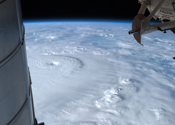
This astronaut photo of Super Typhoon Bopha was taken on Sunday, Dec. 2 from the International Space Station, by Astronaut Ford as the Category 4 storm bore down on the Philippines with winds of 135 mph. Captions and Image source: NASA ISS/JSC
NASA Satellites Analyze Typhoon Bopha Inside and Out, NASA’s Goddard Space Flight Center


