Colorado River into the Gulf of California, Sea of Cortez.
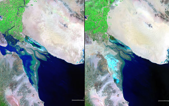
These two pictures illustrate the extremes of water flow in the Colorado River since measurements began in the late 1800s. The 1985 image (Left) was taken in the midst of record high flow, while the 2007 image (Right) shows the driest period. Excessive rains or severe droughts directly change the amount of water available in the Colorado River Basin, and so does the increasing pressure of human needs throughout the western states. The river, which has its headwaters in the snowmelt of the Rocky Mountains, is 1,400 miles (2,253 kilometers) long and empties into the Gulf of California, also known as the Sea of Cortez. Captions and Images source: U.S. Department of the Interior / USGS and NASA.
Excerpts;
Germán Muñoz looked out at the river before him and talked about the days when dolphins swam here, 60 miles from the sea…
Thanks to dams that throttled the Colorado and diverted its water to fuel the rise of the American West, the river has effectively ended at the Mexican border. The Colorado delta, once a lush network of freshwater and marine wetlands and meandering river channels and a haven for fish, migrating birds and other wildlife, is largely a parched wasteland…
Read Full Article, The New York Times
Colorado River Delta, Baja California: Earth Observatory / NASA
By NASA,
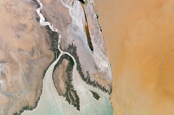
The Colorado River is the largest watershed in the southwestern US, emptying into the Salton Trough before reaching the Sea of Cortez. Over the past 2-3 million years, river sediments built a delta that extends from the US-Mexico border for a distance of 87 miles (140 km). However, today the Colorado River delta is undergoing significant erosion and diminishing in size due to the lack of sediment replenishment from upstream sources.
This image highlights the generally arid setting of the Colorada River delta estuary at its terminus and at low tide.
The Desierto de Altar occupies the right portion of the image. The extensive white salt flats to the southeast of the Cienega (wetland) de Santa Clara are clearly visible. This brackish wetland is a major stopover point for Pacific shore bird migrations and is maintained by groundwater pumped from the southwestern USA.The channel extending from the large island in the center of the image (Isla Montague) to the northwest is an inlet from the Gulf of California which formed after the Colorado River receded due to impoundment of water by Hoover (1935) and Glen Canyon (1964) dams.
It crosses floodplain sediments (gray to dark brown) left by the original river. Gray-brown linear streaks extending southeast from Isla Montague into the Gulf are floodplain sediments mobilized by tidal surges and wave action rather than fluvial processes. Dark green areas bordering the channel, shoreline, and Isla Montague are riparian and estuarine vegetation.
Prior to impoundment of water from upstream dams the delta provided habitat for a wide variety of species including shrimp, corvina fish, and vaquita porpoise. Replacement of water into the delta from groundwater and upstream releases have helped to revive some of the preexisting habitat. This reinvigorated habitat also supports a local ecotourism industry within the delta region. Continuing drought conditions affecting the southwestern USA may decrease water delivery to the delta with significant impacts on both the ecologic and economic health of the region.


