
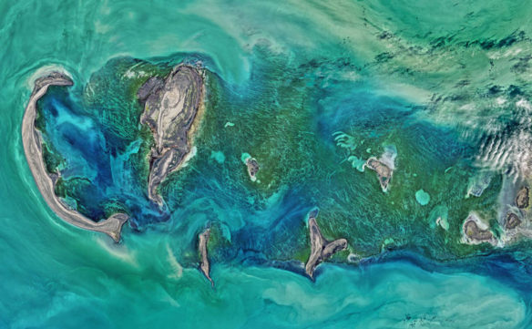
The Operational Land Imager (OLI) on NASA’s Landsat 8 satellite acquired this large natural-color image showing a view of the Caspian Sea around the Tyuleniy Archipelago on April 16, 2016. Ocean scientist Norman Kuring of NASA’s Goddard Space Flight Center found a puzzling feature in the image — lines crisscrossing the North Caspian Sea. On its own, the image was strikingly beautiful. Shallow waters surrounding the Tyuleniy Archipelago allow you to see the dark green vegetation on the sea bottom.Captions and Photo source: NASA image by Norman Kuring, NASA’s Ocean Color web
Excerpts;
Earth’s largest inland body of water has been slowly evaporating for the past two decades due to rising temperatures associated with climate change, a new study finds. Water levels in the Caspian Sea dropped nearly 7 centimeters (3 inches) per year from 1996 to 2015, or nearly 1.5 meters (5 feet) total, according to the new study. The current Caspian Sea level is only about 1 meter (3 feet) above the historic low level it reached in the late 1970s…


