Excerpt:
The ruins of a neighborhood destroyed by a landslide have drawn oglers for decades
Coastal landslides and shifting ground have made headlines recently around Los Angeles, particularly on the otherwise quiet Palos Verdes Peninsula at the southern tip of the county. The looming landmass juts out into the Pacific Ocean near Long Beach and is topped with rolling hillsides, dramatic ocean views and multimillion-dollar homes.
The recent news is alarming — but not new. Nearly a century ago, a landslide in San Pedro swallowed up a huge chunk of an entire neighborhood. The shift destroyed homes built on the edge of a coastal bluff, issuing a warning to future homeowners in the region.
Nearly 100 years on, the concrete ruins of that devastation can still be experienced today.
It’s impossible to be a landowner on the Palos Verdes Peninsula today and not be worried about the uncertain future of the soil below.
In February, the historic (and Instagrammable) Wayfarers Chapel in Rancho Palos Verdes closed indefinitely following reports of a ground shift under the building, leaving happy couples that had landed a coveted wedding date at the venue scrambling to change plans. Trails in the Portuguese Bend Preserve, a popular hiking area offering sweeping views of the Pacific Ocean, are also mostly closed due to potentially hazardous conditions, including “active landslide area, land movement, sink hotels, unstable trails and surfaces, erosion, steep cliffs, and falling rocks.” The city of Rancho Palos Verdes has even called for a state of emergency declaration after recent rains accelerated land movement, threatening dozens of homes.
While land movement has accelerated on the peninsula in recent years, it’s not a new phenomenon for the Southern California coastline. Since development first began in the region, Californians enthralled with ocean views have wanted to live as close to the coast as possible. Sometimes that means putting up with an increased risk of landslides.
Back in the 1920s, residential and commercial development began in the Point Fermin area of San Pedro, a neighborhood on the peninsula. Homes were constructed atop a coastal cliff along the newly built Paseo Del Mar, offering pristine views of the ocean and Catalina Island. But in 1929, those homes began sliding down toward the ocean.
A landslide in the area caused the abandonment of about 14 homes along Paseo Del Mar. In the years since, an estimated 120 feet of horizontal movement and up to 50 feet of vertical movement have occurred, leaving a jagged coastline that is always in flux.
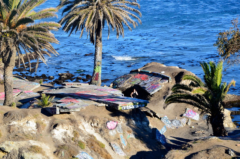
The resulting destruction is still on view today. Locals and tourists alike flock (illicitly) to “Sunken City,” where large blocks of graffiti-covered concrete pile up along the shore below Paseo Del Mar, the end of which suddenly drops off the side of a cliff.
Since the immediate aftermath of the 1929 landslide, people have gathered at the site to ogle the example of natural forces besting development, to party or just to stare out into the ocean. In 1932, with Los Angeles hosting the Olympics, a local plumber tried to capitalize on the landslide, offering Olympic visitors the chance to “prowl about the phenomenon, listen to its tragic history, inspect graphs and even take the temperature of one fissure where the tepid air is emitted…”


