By Mike Carlowicz NASA / Earth Observatory;
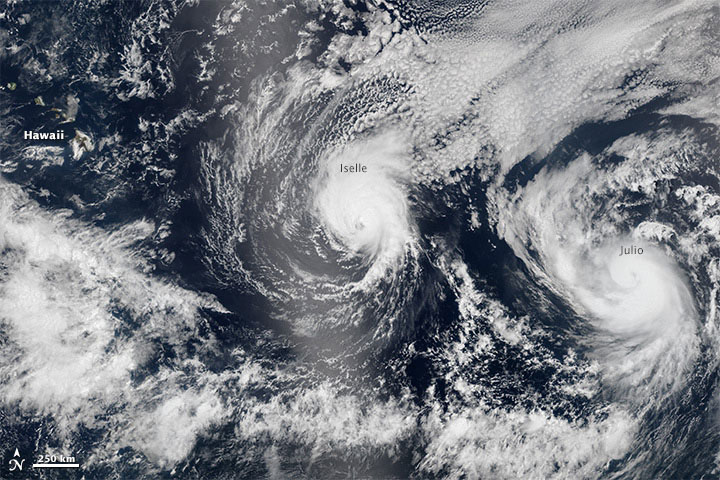
In early August 2014, not one but two hurricanes were headed for the Hawaiian Islands. Storms arriving from the east are a relative rarity, and landfalling storms are also pretty infrequent.
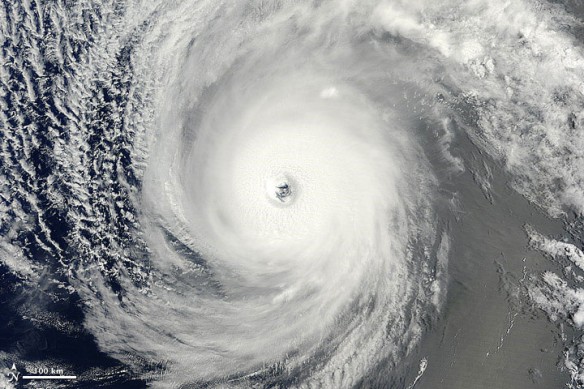
The Moderate Resolution Imaging Spectroradiometer (MODIS) on NASA’s Terra satellite captured this natural-color image of Hurricane Iselle over the Pacific Ocean at 10:40 a.m. Hawaiian time (1940 Universal Time) on August 4, 2014. Shortly after the image was acquired, the U.S. Joint Typhoon Warning Center reported that Iselle was a category 4 hurricane with sustained winds at 120 knots (140 miles or 220 kilometers per hour) and centered at 16.10° north latitude, 137.40° west longitude.
The MODIS image shows a nearly cloud-free eye in the center of a symmetrical storm; there is solid ring of clouds around the center rather than intermittent, spiral bands. Iselle was at its peak intensity at the time and it was likely an annular hurricane. Atmospheric researchers also detected signs of mesovortices near the eyewall. The smaller, tighter rotating structures within the larger storm are often associated with tornadoes on land.
Forecasters from the Central Pacific Hurricane Center predicted on August 6 that Iselle would make landfall on the island of Hawaii as a strong tropical storm or a category 1 hurricane late on August 7. Wind damage and heavy surf are likely, but heavy rainfall, flash floods, and landslides were the greatest concern as Iselle approached.
On August 5, the Visible Infrared Imaging Radiometer Suite (VIIRS) sensor on Suomi-NPP captured natural-color images of both Iselle and Hurricane Julio en route to Hawaii. The image below is a composite of three satellite passes over the tropical Pacific Ocean in the early afternoon. Note that Iselle’s eyewall had grown less distinct; the storm had descreased to category 2 intensity. The bright shading toward the center-left of the image is sunglint, the reflection of sunlight off the water and directly back at the satellite sensor.
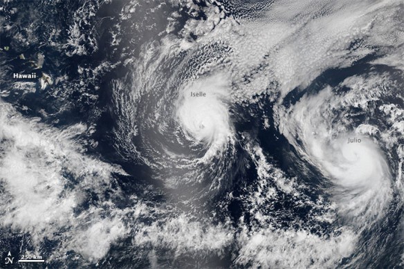
On the same day, Terra MODIS also imaged Iselle and Julio, as well as Hurricane Genevieve (southwest of Hawaii); click here to view that mosaic. The black shapes across the MODIS image are gaps in the satellite’s view. Terra flies in a lower orbit than Suomi-NPP, so its images are narrower and have gaps near the equator, but they can be more detailed.
You can also see a video below of the three storms in motion from August 2–4, as observed by the GOES-West weather satellite.
[youtube]https://www.youtube.com/watch?v=Fbpe2HKGylo[/youtube]
As of midday on August 6, Hurricane Julio was a category 1 storm, but it is expected to weaken to tropical storm force in the coming days. Forecasts suggest that the eye will pass north of the Hawaiian Islands on August 10, but it is possible that there will be some effects on land.
Read Original Article, NASA / Earth Observatory
Why Hurricanes Are So Rare in Hawaii? Climate Central
Hurricanes and tropical storms are normally steered clear of the Hawaiian Islands by a high pressure feature that is typically parked to the northeast of the islands and keeps the weather consistent throughout the year. That high pressure is particularly strong from May through October — prime hurricane season…

