
NASA Earth Observatory images by Joshua Stevens, using Landsat data from the U.S. Geological Survey; acquired July 7, 2017
NASA Earth Observatory images by Joshua Stevens, using Landsat data from the U.S. Geological Survey; acquired February 16, 2018.
By Kathryn Hansen, NASA / Earth Observatory;
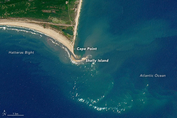
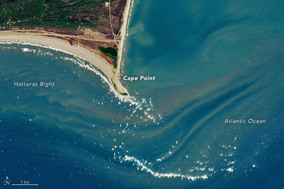
When a sandbar developed off the shore of North Carolina’s barrier islands in spring 2017, some experts said that the feature was likely to be short-lived. They were right. Since then, a series of storms has redistributed the sand and the so-called “Shelly Island” is no longer an island.
The Operational Land Imager (OLI) on the Landsat 8 satellite acquired these views of Cape Point at Cape Hatteras National Seashore. The top image shows the area on July 7, 2017, when the island was still growing. (It peaked at 27 acres in late August 2017, according to news reports.) The second image was acquired on February 16, 2018, after the island had disappeared. Turn on the image-comparison tool to see the change.
The reasons for the island’s formation and evolution are complex and not entirely clear. Coastal scientists have speculated that weather conditions were just right in 2017. Winds were strong enough to stir up the waves and currents that carry sand alongshore from the more northerly barrier islands toward the cape. Then winds became calm enough for that sand transport to be halted by obstacles such as circular currents within Hatteras Bight and the expansive shoals of the cape. Sand accumulated, an island grew, and tourists flocked to the area to witness the spectacle.
The reasons for the island’s demise are somewhat clearer. Erosion occurs all of the time on barrier islands, but it was especially acute in the fall when it was fueled by a series of hurricanes, including Irma and Jose in early September, and Hurricane Maria later that month. According to news reports, the storms split the island; one half became connected to the tip of the cape, while the other tiny remnant remained isolated. Winter storms continued to batter what was left of the island and wash it away.
Despite the public attention paid to the rise and fall of Shelly Island, such swift changes are common along barrier island systems. The shoreline and cape tips along North Carolina are constantly in motion, as waves and currents redistribute land-building materials.
Original Article; NASA / Earth Observatory (03-08-2018)
While a new island grew, southern Hatteras was shrinking, NC; The Outer Banks Voice (11-01-2017)
Whatever forces crafted the new, crescent-shaped island at Cape Point is steadily gulping down the south end of Hatteras Island, spitting aside trees, power poles and a popular route for off-road vehicles…
Irma builds bridge between Hatteras Point and Shelly Island; The Outer Banks Voice (09-20-2017)
Rough surf from Hurricane Irma brought more than just great waves to the popular Shelly Island sandbar. It also brought some dramatic changes to the long formation off of Cape Point…
New Island Appears Off U.S. Coast; The National Geographic (06-27-2017)
It appeared out of nowhere in April just off North Carolina’s Outer Banks—a new land mass poking through the surf, a brand new Atlantic Ocean island. This new formation is of a scale rarely seen…
“The Beaches Are Moving,” A Video featuring Orrin Pilkey, PhD
World famous coastal geologist Orrin H. Pilkey takes us to the beach and explains why erosion has become a problem…


