
The Channel Islands Region, California.
Photo Source: NASA
Excerpt from the Smithsonian Institution
Should global warming cause sea levels to rise as predicted in coming decades, thousands of archaeological sites in coastal areas around the world will be lost to erosion. With no hope of saving all of these sites, archaeologists Torben Rick from the Smithsonian Institution, Leslie Reeder of Southern Methodist University, and Jon Erlandson of the University of Oregon have issued a call to action for scientists to assess the sites most at risk.
Writing in the Journal of Coastal Conservation and using California’s Santa Barbara Channel as a case study, the researchers illustrate how quantifiable factors such as historical rates of shoreline change, wave action, coastal slope and shoreline geomorphology can be used to develop a scientifically sound way of measuring the vulnerability of individual archaeological sites. They then propose developing an index of the sites most at risk so informed decisions can be made about how to preserve or salvage them.
Urban development, the researchers point out, also is a significant threat to the loss of archaeological data. Coastlines have long been magnets of human settlement and contain a rich array of ancient archaeological sites, many of which have never been excavated. Urban development is projected to remain high in coastal areas, representing a significant danger to undisturbed sites.
Thousands of archaeological sites, from large villages and workshops to fragmented shell middens and lithic scatters, are perched on the shorelines and sea cliffs of the Santa Barbara Channel, the researchers point out.

Santa Barbara Channel Islands, Santa Rosa and Santa Cruz.
Photo Source: NASA
The archaeological record is never static, and the materials left behind by one generation are altered by the people and environment of the next. However, increasing threats from modern urban development, sea level rise and global warming are poised to increase this steady pattern of alteration and destruction.
The vulnerability of sites in the Santa Barbara Channel is generally lower than sites located along more open, more gently sloped or unstable coastlines, such as the Atlantic and Gulf coasts of North America.
Native artifacts being washed away by rising surf: The Channel Islands, California; AP /NBC

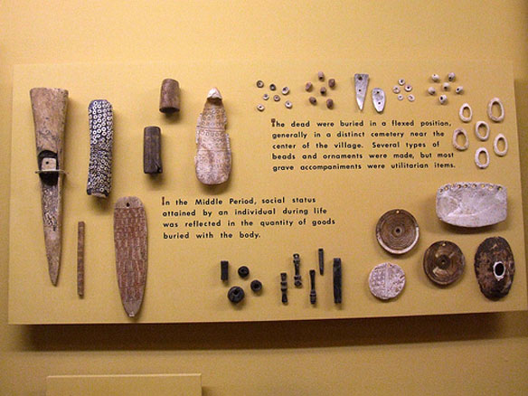
Chumash Indians of the Channel Islands’ artifacts. To the left are bone tools and dagger. The black and white piece is a bone piece laden with asphaltum and shell beads, which may create a better grip. Along the top are different kinds of shell beads. Photo Source: Travis S, Santa Barbara Museum of Natural History
Excerpts;
Perched on the edge of this wind-swept Southern California island, archaeologist Jon Erlandson watches helplessly as 6,600 years of human culture, and a good chunk of his career, is swallowed by the Pacific surf.
It was not long ago that this tip of land on the northwest coast cradling an ancient Chumash Indian village stretched out to sea. But years of storm surge and roiling waves have taken a toll. The tipping point came last year when a huge piece broke off, drowning remnants of discarded abalone, mussel and other shellfish that held clues to an ancient human diet.
“There’s an enormous amount of history that’s washing into the sea every year,” Erlandson said matter-of-factly during a recent hike. “We literally can’t keep up.”
The sea has long lashed at the Channel Islands, also known as the North American Galapagos, stripping away beaches, slicing off cliff faces and nibbling at hundreds, perhaps thousands, of cultural relics.
Past coastal erosion for the most part was a natural phenomenon, but the problem is feared to grow worse with human-caused global warming and higher sea levels.
In 2005, the U.S. Geological Survey found that half of the 250 miles of shoreline studied on the Channel Islands were vulnerable to sea level rise. The most at-risk were the San Miguel and Santa Rosa coasts, home to thousands of archaeological relics from house pits to trash heaps to random scatters of stone anvils and burned rocks…


