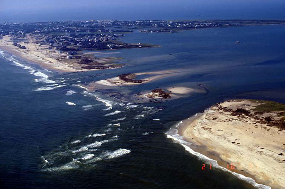

Coastal erosion. Inlets can open during severe storms and fragment narrow barrier islands. Inlet opening is especially pertinent for the Outer Banks of North Carolina due to narrow island widths and low elevations. Image source: USGS
National Assessment Of Shoreline Change: Part 1 Historical Shoreline Changes And Associated Coastal Land Loss Along The U.S. Gulf Of Mexico, A report by Robert A. Morton, Tara L. Miller, and Laura J. Moore / U.S. Geological Survey
Executive Summary
Beach erosion is a chronic problem along most open- ocean shores of the United States. As coastal populations continue to grow and community infrastructures are threatened by erosion, there is increased demand for accurate information regarding past and present trends and rates of shoreline movement.
There is also a need for a comprehensive analysis of shoreline movement that is consistent from one coastal region to another. To meet these national needs, the U.S. Geological Survey is conducting an analysis of historical shoreline changes along open-ocean sandy shores of the conterminous United States and parts of Hawaii and Alaska.
One purpose of this work is to develop standard repeatable methods for mapping and analyzing shoreline movement so that periodic updates regarding coastal erosion and land loss can be made nationally that are systematic and internally consistent.
This report on states bordering the Gulf of Mexico (Florida, Alabama, Mississippi, Louisiana, and Texas) represents the first in a series that will eventually include the Atlantic Coast, Pacific Coast, and parts of Hawaii and Alaska. The report summarizes the methods of analysis, interprets the results, provides explanations regarding the historical and present trends and rates of change, and describes how different coastal communities are responding to coastal erosion.
Shoreline change evaluations are based on comparing three historical shorelines with a recent shoreline derived from lidar (Light Detection and Ranging) topographic surveys. The historical shorelines generally represent the following periods: 1800s, 1920s-1930s, and 1970s, whereas the lidar shoreline is 1998-2002. Long-term rates of change are calculated using all four shorelines (1800s to lidar shoreline), whereas short- term rates of change are calculated for the most recent period (1970s to lidar shoreline). The historical rates of change presented in this report represent past conditions and therefore are not intended for predicting future shoreline positions or rates of change.
Rates of erosion for the Gulf of Mexico region are generally highest in Louisiana along barrier island and headland shores associated with the Mississippi delta. Erosion is also rapid along some barrier islands and headlands in Texas, and barrier islands in Mississippi are migrating laterally. Highest rates of erosion in Florida are generally localized around tidal inlets. The most stable Gulf beaches are along the west coast of Florida where low wave energy and frequent beach nourishment minimize erosion. Some beach segments in Texas have accreted as a result of net longshore drift convergence, and around tidal inlets that have been stabilized by long jet- ties.
Seawalls and riprap revetments were constructed in all the Gulf Coast states as initial community responses to long-term beach erosion. Although some states, such as Florida, still permit shoreline stabilization structures, beach nourishment has become the preferred method of mitigating long- term erosion…


