
By NASA earth Observatory
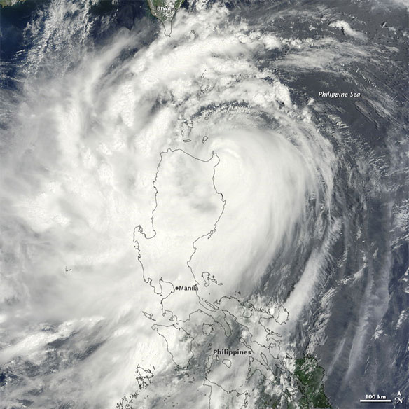
Although no longer a super typhoon on August 27, 2011, Nanmadol remained a powerful storm, classified as a Category 3 typhoon. The storm lingered over the northern Philippines, and stretched as far north as Taiwan. The Moderate Resolution Imaging Spectroradiometer (MODIS) on NASA’s Terra satellite captured this natural-color image the same day.
After MODIS took this picture, Nanmadol continued traveling north, and caused substantial flooding in Taiwan, according to Voice of America. Packing winds of 100 kilometers (60 miles) per hour, the storm forced the closure of schools and businesses, and the evacuation of more than 6,000 island residents.
Typhoon Floods homes and farmlands, heading to China, AP
A typhoon that flooded homes, roads and farmland in Taiwan with more than 20 inches of rain left the island Monday and headed to southeastern China.
Typhoon Slams Southeast Asia, on its way to China, AFP
Taiwan evacuated 2,500 villagers from the east and south of the island on Sunday, the Central Emergency Centre said, with the authorities urging the public to stay away from mountainous and low-lying areas.
Photos Gallery: Southeast Asia Ravaged By Typhoon, Le Figaro
Nanmadol Typhoon, Updates Wikipedia
After Nanmadol left the island nation of Taiwan and entered the Taiwan strait, Local authorities started calling back several thousands of ships informing them about the heavy rain the typhoon was pouring.The Maritime affairs bureaus of Fuzhou, Putian, Quanzhou, Xiamen and Zhangzhou cities activated the red warning, the highest level on the Chinese scale, ordering all ships to return to the harbor as soon as possible. The storm was expected to bring heavy torrential rains and flash flooding as is makes landfall on the the southern part of Fujian province, China.


