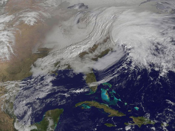

Captured by NASA’s GOES-13 weather satellite on Friday, Feb. 8, this image shows the convergence of two massive low-pressure systems that are expected to bring high winds and up to 2–3 feet of snowfall across much of New England over the next 24 hours. This is the second and most powerful “nor’easter” of the season, and states in the region are preparing for the worst. Image source: NASA / GOES Project
By Stephanie Tunmore / Greenpeace;
Extreme weather has already pounded communities around the world this year with extreme heat, wild fires, and floods in Australia, record heat in southern Africa and Patagonia while a cold wave hit India and China. The U.S. saw a massive tornado outbreak and record warm temperatures ahead of the system that spawned the severe weather.
The trend is continuing into February with the US National Oceanic and Atmospheric Administration warning of a potentially historic winter storm and blizzard forming off the northeast of the country and expected to drop more than a foot of snow from New York City to Boston over the weekend. More than 50 million people live in the storm impact area
The storm is a result of two separate atmospheric systems merging off the Mid-Atlantic coast creating one massive storm centre expected to move northeastward. Hurricane winds and storm surges are also predicted, as the storm (named Nemo by the Weather Channel) intensifies.
The presence of unusually warm Atlantic waters could aid in the rapid development of the storm system, and infuse it with additional moisture, thereby increasing snowfall total.
A severe weather watch for the east coast city of Boston warns of up 18 to 24 inches of snowfall for the city. Boston has only received over 24 inches of snow during 4 storms in its recorded history.
There are fears that if the peak winds coincide with the Saturday morning high-tide cycle, moderate to major coastal flooding could result from New Jersey northeastward, with the greatest risk of flooding between Boston and Cape Cod as hurricane-force wind gusts build waves to heights of at least 20 feet. A storm surge of 3-to-4 feet is forecast in eastern Massachusetts, and the National Weather Service (NWS) is warning that coastal areas whose defences were weakened by Hurricane Sandy may experience more beach erosion and potential flooding, even though the storm surge will be far lower during this event.
Scientists have warned for some time that certain types of extreme weather will become more frequent and more intense as natural variability joins with background conditions altered by long-term climate change to supercharge events. It is expected for instance that there are likely to be more strong storms outside the tropics, with stronger winds and more extreme wave heights.
View Animation, NASA
Two low pressure systems merged over New England around midnight (EST) on Feb. 9, 2013. This animation of NOAA’s GOES-13 satellite imagery from Feb. 7 to Feb. 9 shows the two systems coming together and creating a blizzard of historic proportions in New England. On Feb. 9 at 4 a.m. hundreds of thousands of people were without power in Massachusetts alone.
Massive snowstorm Nemo strikes Northeast; at least 4 dead, New York Daily News


