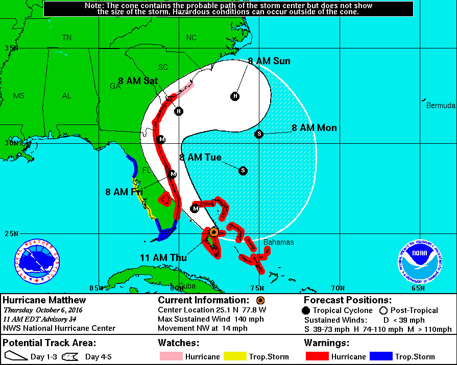
October 6, 2016. This graphic shows an approximate representation of coastal areas under a hurricane warning (red), hurricane watch (pink), tropical storm warning (blue) and tropical storm watch (yellow). The orange circle indicates the current position of the center of the tropical cyclone. Captions and Image source: NHC / NOAA
Excerpts;
Hurricane Matthew has strengthened to a catastrophic Category 4 storm as it barrels toward the heavily populated coast of Florida…
Read Full Article, CBS News (10-06-2016)
Hurricane Matthew’s U.S. Impacts: Life-Threatening Storm Surge, Damaging Winds, Flooding Rainfall; Weather Channel (10-06-2016)
An important point to make is that landfall does NOT need to take place for the worst impacts to come ashore. The strongest winds and most drilling surge will come to the coast in the eyewall, which surrounds the eye. Landfall occurs when the calmest portion of the eye, or the center, comes ashore. Hurricane conditions will come ashore even if the center stays 20 to 30 miles offshore…
Hurricane Matthew to trigger storm surge, beach erosion; USA Today (10-05-2016)
The biggest threat Matthew poses may be storm surge. Storm surge, according to the National Hurricane Center, is seawater pushed toward the shore by winds moving around a storm. How high the surge is depends on barometric pressure and the intensity, speed, size and angle of the storm…
Hurricane Matthew en route to Florida, NASA / Earth Observatory (10-07-2016)


