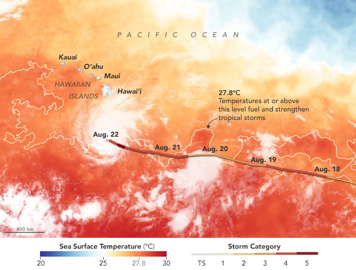

Hurricane Lane. According to the National Weather Service in Honolulu, only one other category 5 hurricane in database records passed within 560 kilometers (350 miles) of Hawaii.The westward path of Lane’s track from August 15 to August 22 is shown here. The track is overlaid on a map of sea surface temperatures in the tropical Pacific Ocean on August 21, 2018. Captions and Image source: NASA / Earth Observatory
Excerpts;
Hurricane Lane had grown to a Category 5 storm Tuesday night, packing maximum sustained winds of 160 miles an hour, according to the National Weather Service.
Hurricane Lane then weakened to a Category 4 storm on Wednesday, but the hurricane still has winds of up to 155 miles an hour and remains the most powerful hurricane to threaten Hawaii in more than two decades…
Read Full Article; The Atlantic (08-22-2018)
Lane – Formerly 14E (Eastern Pacific) – Hawaii; NASA GPM (08-22-2018)
Hurricane Lane is one of the strongest tropical cyclones to move into the Hawaiian Islands. The GPM core observatory satellite flew over the Central Pacific Ocean and Hurricane Lane on Aug. 22, 2018 and analyzed rainfall rates and cloud heights. Watches and Warnings are in effect in the Hawaiian Islands…
Hurricane Lane Approaches Hawaii; NASA / Earth Observatory (08-22-2018)
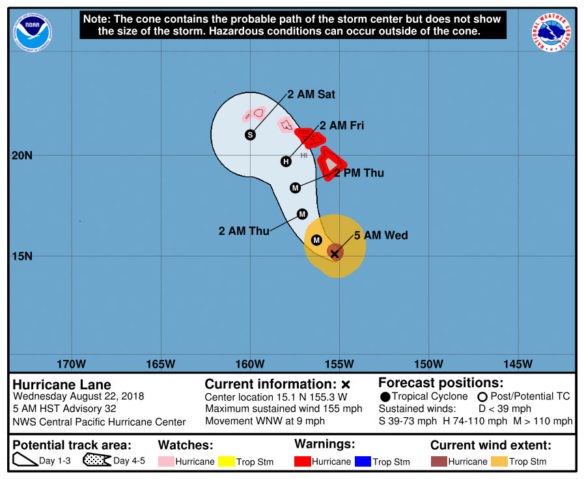
Hurricane Lane, Coastal Watches/Warnings and Forecast Cone for Storm Center. Image source: NHC / NOAA


