
The team found that about 31 percent of the world’s coastlines are sandy. Africa has the highest proportion of sandy beaches (66 percent) and Europe has the lowest (22 percent).
By Jessica Merzdorf, NASA’s Goddard Space Flight Center, with Mike Carlowicz, NASA Earth Observatory;
A new survey has shown that the world’s sandy beaches have grown slightly over the past three decades. But researchers also observed a troubling trend in protected marine areas.
A team of researchers from The Netherlands used machine learning to accurately identify sandy beaches in images taken by Landsat satellites. They “taught” their image-classification software to automatically determine whether beaches around the world were sandy, rocky, or icy, and then to examine how the sandy beaches changed between 1984 and 2016.
The team found that about 31 percent of the world’s coastlines are sandy. Africa has the highest proportion of sandy beaches (66 percent) and Europe has the lowest (22 percent).
Thy also found that 24 percent of those sandy beaches—a coastline distance of almost 80,000 kilometers (50,000 miles)—had eroded at rates exceeding 0.5 meters per year. Another 28 percent of sandy beaches had accreted (grew), while 48 percent remained stable. Four of the seven largest erosion hot spots in the world were located in the United States.
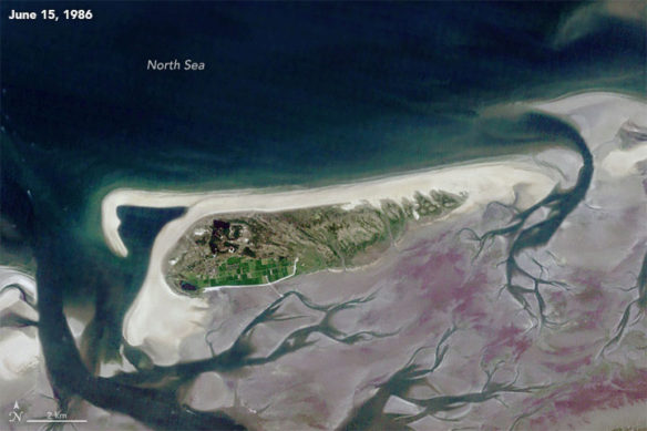
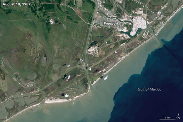
The image pairs on this page show two of the extreme cases. The beaches at Schiermonnikoog, The Netherlands (above), were among the fastest growing in the study, with growth of nearly 10 meters per year. The area just south of Freeport, Texas (below), is one of the largest erosive hotspots in the world, with beach being lost at a rate of nearly 15 meters per year along a 17-kilometer (11-mile) stretch. These natural-color images were acquired by the Thematic Mapper on Landsat 5 and the Operational Land Imager on Landsat 8.
A new survey has shown that the world’s sandy beaches have grown slightly over the past three decades. But researchers also observed a troubling trend in protected marine areas.
A team of researchers from The Netherlands used machine learning to accurately identify sandy beaches in images taken by Landsat satellites. They “taught” their image-classification software to automatically determine whether beaches around the world were sandy, rocky, or icy, and then to examine how the sandy beaches changed between 1984 and 2016.
The team found that about 31 percent of the world’s coastlines are sandy. Africa has the highest proportion of sandy beaches (66 percent) and Europe has the lowest (22 percent).
Thy also found that 24 percent of those sandy beaches—a coastline distance of almost 80,000 kilometers (50,000 miles)—had eroded at rates exceeding 0.5 meters per year. Another 28 percent of sandy beaches had accreted (grew), while 48 percent remained stable. Four of the seven largest erosion hot spots in the world were located in the United States.
The image pairs on this page show two of the extreme cases. The beaches at Schiermonnikoog, The Netherlands (above), were among the fastest growing in the study, with growth of nearly 10 meters per year. The area just south of Freeport, Texas (below), is one of the largest erosive hotspots in the world, with beach being lost at a rate of nearly 15 meters per year along a 17-kilometer (11-mile) stretch. These natural-color images were acquired by the Thematic Mapper on Landsat 5 and the Operational Land Imager on Landsat 8.
Original Article, NASA / Earth Observatory (08-02-2018)
Global Study of World’s Beaches Shows Threat to Protected Areas; NASA’s Goddard Space Flight Center (07-18-2018)
A first-of-its-kind survey of the world’s sandy shorelines with satellite data found that they have increased slightly on a global scale over the past three decades but decreased in protected marine areas, where many beaches are eroding…


