The Pacific Ocean is running a fever. Why that’s an ominous sign – the Washington Post
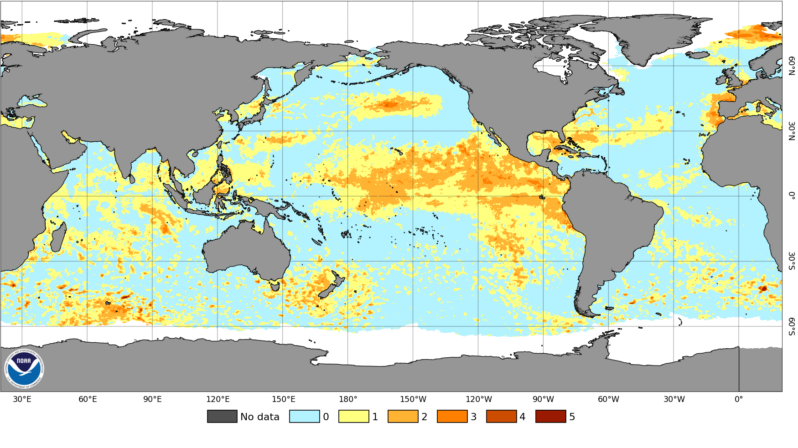
A marine heat wave covering an area eight times the size of the United States could soon fuel serious storms and extreme heat..
Scientists just got some ancient clues about future sea-level rise – the Washington Post

Tangier Island — off the mainland coast of Virginia — is one of the last inhabited islands in the Chesapeake Bay. Before colonial settlers arrived in the 1700s, Indigenous people likely traveled to the island in the summer to take advantage of the abundant fish and crabs…Many descendants of the original settlers — with surnames like Crockett, Parks and Thomas — have remained to this day. The isolation has allowed the development of a unique accent, one that some residents describe as a mix between “Southern” and “Elizabethan” English….
This small Virginia island could be underwater before the next century – NPR

Tangier Island — off the mainland coast of Virginia — is one of the last inhabited islands in the Chesapeake Bay. Before colonial settlers arrived in the 1700s, Indigenous people likely traveled to the island in the summer to take advantage of the abundant fish and crabs…Many descendants of the original settlers — with surnames like Crockett, Parks and Thomas — have remained to this day. The isolation has allowed the development of a unique accent, one that some residents describe as a mix between “Southern” and “Elizabethan” English….
Entire row of seaside homes where house prices have plummeted by £600k – Manchester Evening News

The road has become lined with ‘for sale’ signs as residents look to escape the rising tide…
First sea-level records for coastal community protection – the European Space Agency

Satellites have revolutionised our ability to measure sea level but their data becomes less reliable near coasts…To address this critical gap, ESA’s Climate Change Initiative Sea Level Project research team has reprocessed almost two decades of satellite data to establish a pioneering network of ‘virtual’ coastal stations. These stations now provide, for the first time, reliable and consistent sea-level measurements along coastlines…
How Nantucket Is Preparing for Rising Seas – Inside Climate News

Sea-level rise threatens coastal communities even if global emissions drop…
New Study Projects Climate-Driven Flooding for Thousands of New Jersey Homes – Inside Climate News

Sea-level rise threatens coastal communities even if global emissions drop…
Global sea level rose higher than expected last year. Here’s why – the Washington Post

The rate of global sea level rise follows a trend of rapidly increasing rates over the past 30 years…
What Causes Sea Level Rise? – NASA Space Place

People have been measuring local sea level at certain locations along the coasts for hundreds of years. And NASA has been measuring the global sea level for almost three decades. Over this time, scientists have observed that the global sea level has been rising. The ocean is about 7 to 8 inches higher now than it was a century ago. Why? Because Earth is getting warmer…