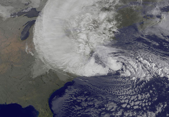

NOAA’s GOES-13 satellite captured this visible image of Hurricane Sandy battering the U.S. East coast on Monday, Oct. 29 at 9:10 a.m. EDT. Sandy’s center was about 310 miles south-southeast of New York City. Tropical Storm force winds are about 1,000 miles in diameter. Image and Captions: NASA GOES Project
Excerpts;
On Monday, Oct. 29, Hurricane Sandy was ravaging the Mid-Atlantic with heavy rains and tropical storm force winds as it closed in for landfall.
Earlier, NASA’s CloudSat satellite passed over Hurricane Sandy and its radar dissected the storm get a profile or sideways look at the storm. NASA’s Aqua satellite provided an infrared view of the cloud tops and NOAA’s GOES-13 satellite showed the extent of the storm.
The National Hurricane Center reported at 11 a.m. EDT on Oct. 29 that Hurricane Sandy is “expected to bring life-threatening storm surge and coastal hurricane winds plus heavy Appalachian snows…”
Near Landfall, Storm Pounds East Coast, The New York Times
The full moon on Monday could cause even greater flooding, because tides will be at their peak. It was the possibility of a surge that prompted many to take precautions. The hurricane center said the surges could reach 11 feet in New York Harbor, Long Island Sound and Raritan Bay in New Jersey, significantly higher than previous forecasts and significantly above the levels recorded during the tropical storm last year.


