
“Old writting from Cascadia offer few hints that subduction zone produces great earthquakes or tsunamis. Such events are unknown from the records of early explorere like Bruno de Hezeta y Dudagoifia, who mapped the mouth of Washington’s Quinaults river in 1775. The oral traditions of Cascadia’s native peoples, however tell of flooding from the sea. (see James Swan’s Diary, 1864, at neah Bay, Washington, home of the Makah Tribe.) Swan’s informant, Billy Balch, was a Makah leader. Balch recounts a sea flood in the not very remote past. It began by submerging the lowland between Neah Bay and the Pacici Ocean. next, the water receded for four days. Rising again without any swell, the sea covered all but the highest ground on both sides of the Syrait of Juan de Fuca. It dispersed tribes, strandes canoes in trees, and caused numerous deaths…” Captions and Photo source: PUBS/ USGS
Excerpts;
In 1700, a massive earthquake struck the west coast of North America. Though it was powerful enough to cause a tsunami as far as Japan, a lack of local documentation has made studying this historic event challenging.
Now, researchers from the University of Pennsylvania have helped unlock this geological mystery using a fossil-based technique. Their work provides a finer-grained portrait of this earthquake and the changes in coastal land level it produced, enabling modelers to better prepare for future events…
Read Full Article, Science Daily
The Orphan Tsunami of 1700 – Japanese Clues to a Parent Earthquake in North America, Pdf File, USGS
One winter’s night in the year 1700, a mysterious tsunami flooded fields and washed away houses in Japan. It arrived without the warning that a nearby earthquake usually provides. Samurai, merchants, and villagers recorded the event, but nearly three centuries would pass before discoveries in North America revealed the tsunami’s source.The Orphan Tsunami of 1700 tells this scientific detective story through clues from both sides of the Pacific. The evidence uncovered tells of a catastrophe, a century before Lewis and Clark, that now helps guide preparations for future earthquakes and tsunamis in the United States and Canada.

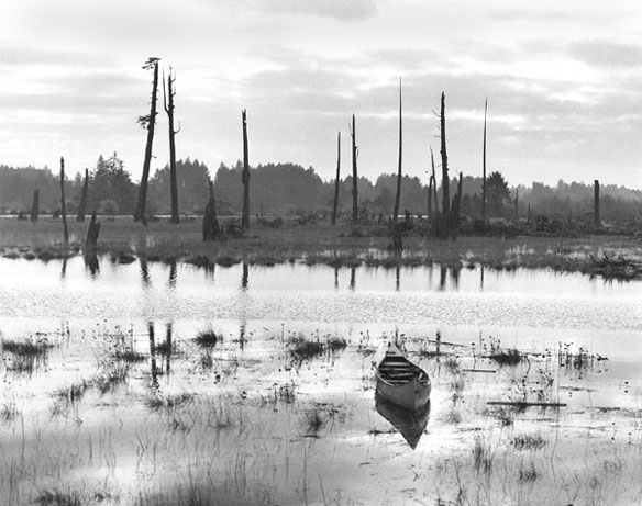
This “ghost forest” near the mouth of the Copalis River, Washington, was killed by saltwater tides after an earthquake in 1700 caused the land to subside. Photograph taken by Brian Atwater. Captions and Photo source: Soundwaves / USGS


