


By William J. Neal, Department of Geology, Grand Valley State University, Allendale, MI
Thinking of beaches may not bring to mind Eastern Canada, particularly Nova Scotia’s rugged Cape Breton Island, but this beautiful coast has several pocket and bay-mouth bar beaches as scenic as any to be found in North America.
Four-Mile Beach is an example of the latter, controlled by its geologic setting, and a sediment supply from the erosion of adjacent bluffs and cliffs, and transport by longshore currents. Aspy Bay on the northeast side of Cape Breton occupies a topographic low between highlands of ancient granites and metasediments that jut into the Atlantic as great headlands. Baymouth bars grew across the inner embayment from north to south as sediments were carried by the longshore currents from these adjacent headlands, creating a chain of barrier beaches connecting smaller bedrock headlands. [Photo A]
These barrier beaches behave somewhat like narrow barrier islands in that they are breached by inlets, and washed over by storm waves. Four-Mile Beach is appropriately named as its total distance is close to 4 miles, however, the beach is not continuous and is interrupted by a couple of inlets and the harbor entrance to the small fishing village of Dingwall. The best beach access is via the Cabot Landing Provincial Park (lat. 46° 56’ 34” N; long. 60° 27’ 45” W; north off of the Cabot Trail Highway on Bay St. Lawrence Road, just north of Sugar Loaf).
Swimming in the cold Canadian waters is not for the faint of heart, however this beach provides an excellent natural setting for hiking and beach combing. The brownish red, coarse sand reflects compositions of the eroding source rocks where the beach originates against the sea-cliff faces, and the sand fraction is dominated by quartz, pink feldspar, and sand-to-gravel sized rock fragments. [Photo B]
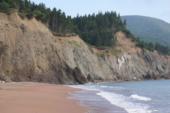
Glacially derived sediments make up the low bluffs in the vicinity of the park, and account for a wide variety of rock types found in the coarser gravel fraction. [Photo C]
A mat of tree roots and bound soil overhangs the erosional scarp. The bare rock outcrops and layered sediments that make up the cliff and bluff faces at the back of the north beach are evidence of significant erosion from both waves and mass wasting. Large slumps cut well back into the upland heights which fortunately are not developed. [Photo D]
Continuing south onto the barrier beach, the sediments tend to become finer, better sorted sands, although patches of gravel are concentrated at the storm-tide line and in the heads of cusps. [Photo E]
At times, sand hoppers abound and the beach surface seems to be moving. When their shallow holes are flooded by wave swash, escaping air creates miniature sand volcanoes. [Photo F]
Finer wind-blown sands have built a continuous, low foredune along most of the baymouth portion of the beach. [Photo G]
The role of beach grass in trapping the sand is apparent, and has produced a suitable habitat for piping plovers. Unfortunately, visitors do not heed park signs that warn to keep dogs on leashes, and not to walk in the dune areas where nesting occurs.During any given visit one finds wrack lines of marine plants washed ashore, and often man-made materials such as the occasional lobster trap. On our visit, the wrack line had an abundance of what appeared to be shredded white, paper-like material of unidentified origin. [Photo H]


