Authors:
William J. Neal and Benjamin S. Burroughs, Geology Dept., Grand Valley State University, Allendale, MI, and Marguerite A. Hertstein, Grand Rapids, MI
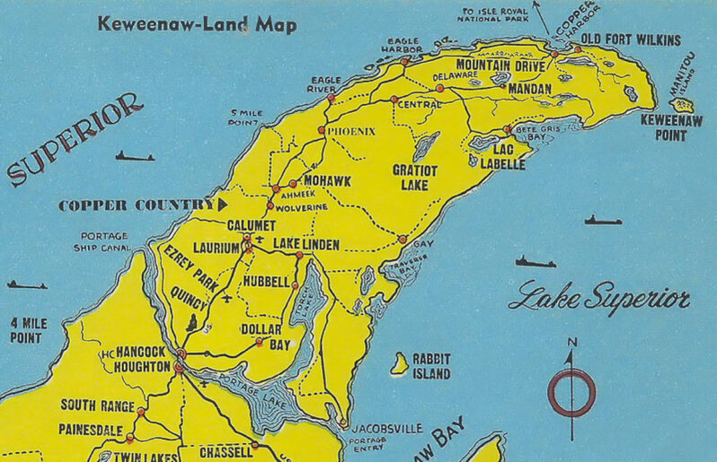
The book, Vanishing Sands (Pilkey et al., 2022), examined global beach losses due to direct mining of beaches and other sources of beach sand (e.g., rivers, dunes). However, natural beaches can be lost from having gained sediments as the result of mining operations. Such is the case of mining impacts in the form of stamp-sand beaches on Michigan’s Keweenaw Peninsula shores and shallows of Lake Superior (Figures 1 and 2).
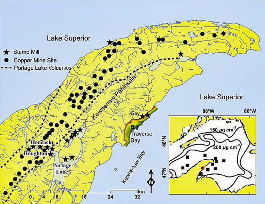
Figure 1. Index Map (after Kerfoot et al. 2004, 2019, 2021) of Keweenaw Peninsula that juts out into southern Lake Superior (Inset). The region was subject to intensive mining of copper and other metal ores in the 19th and 20th centuries from the zones of Precambrian meta-igneous and sedimentary rocks (e.g., the ore-bearing Portage Lake Volcanics). Initial processing of the ores was in stamp mills (stars) located next to inland waters (e.g., Portage Lake, Keweenaw Waterway, Torch Lake), and at three locations on the Lake Superior shore: Gay the focus of this paper (color-shaded area of Big Traverse Bay with coastal stamp-sand accumulation through time); Freda/Redridge on the NE shore; and Mass Mill near Baraga at the SE shore of Keweenaw Bay (SE corner of Peninsula on Inset – no star). Kerfoot et al. (2004) studies of sediment cores from Lake Superior show widespread copper concentration (contours) with high concentrations of 200—400 g cm-2 shown at black squares.
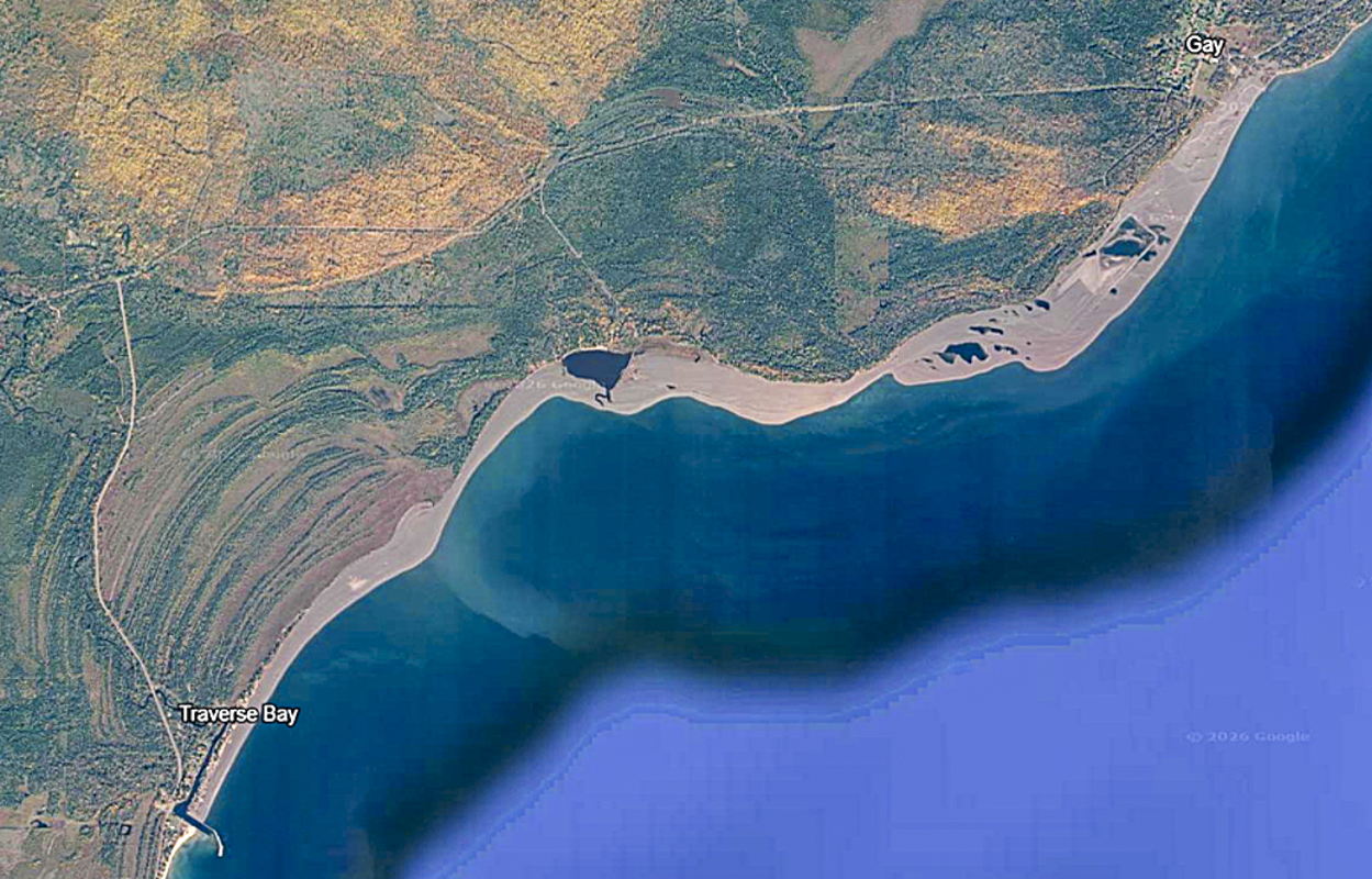
Figure 2. 1985 Google Earth image of the Gay mills stamp sand coastal deposit (gray unvegetated zone) extending from north of the village of Gay (upper right; mills site) to the Traverse River jetties at Traverse Bay village (lower left); a shoreline distance of over 5 miles. The large pond midway between Gay and the river jetties is the old Coal Dock site. The dominant subaerial deposit formed by sediment being carried from NE to SW and appears to terminate against the river’s north jetty. However, huge amounts of this waste material are deposited on the nearshore lake bottom, and the eroded suspended silts and clays are carried far offshore (e.g., greenish-blue zone along wider part of deposit and plume extending lakeward).
Copper deposits in the Keweenaw Peninsula have been utilized/mined for an 8000-year time span from Indigenous Peoples to 18th century European exploration (NPS, 2025), the first mine in 1771, and to the “Age of Copper” in the 19th and 20th centuries when the Michigan copper boom reached its peak. The number of mines (Figure 1) and boomtowns rapidly increased as did the number of stamp mills to crush ore and recover the copper, and in some cases silver. The Keweenaw region’s copper ores were from zones of Precambrian metamorphosed igneous and sedimentary rocks (e.g., ore-bearing Portage Lake Volcanics; Calumet Conglomerate). Ores were processed in stamp mills to recover the native copper or copper-bearing minerals for shipment to smelters. These mills were located next to the shores and shallows of inland waters (e.g., Portage Lake, Keweenaw Waterway, Torch Lake) as well as Lake Superior for processing water supply and for disposal of the tons of waste sediments (dumps of convenience) generated by the rock crushing. Three major mill sites located on the Lake Superior shore were the Champion Mill in the Freda/Redridge area (1903 to 1967), the Mass Mill at the south end of Keweenaw Bay (1902 to 1919), and the Mohawk (1902 to 1932) and Wolverine (1902 to 1925) Mills at Gay, Michigan (Figure 1).
The Gay site and impacted area have been dubbed a “$1billion eco-disaster” (Ellison, 2022) and is the focus of this photo essay on how a natural beach was turned into a zombie beach (Figure 2). Here the “stamp sands” were deposited directly onto the beach and into the nearshore waters, setting off a century-long cascade of environmental destruction. While the environmental impacts are varied and spectacular, we were drawn to reviewing mainly the impact on the natural beach, visiting the site in 2023 and 2024 to specifically collect natural beach sands south of the river jetties (Figure 2) and at the source near Gay (Figure 3). Although these deposits are referred to as “stamp sands,” the actual grain sizes range from small pebbles through sand to silt and clay (Figure 4).
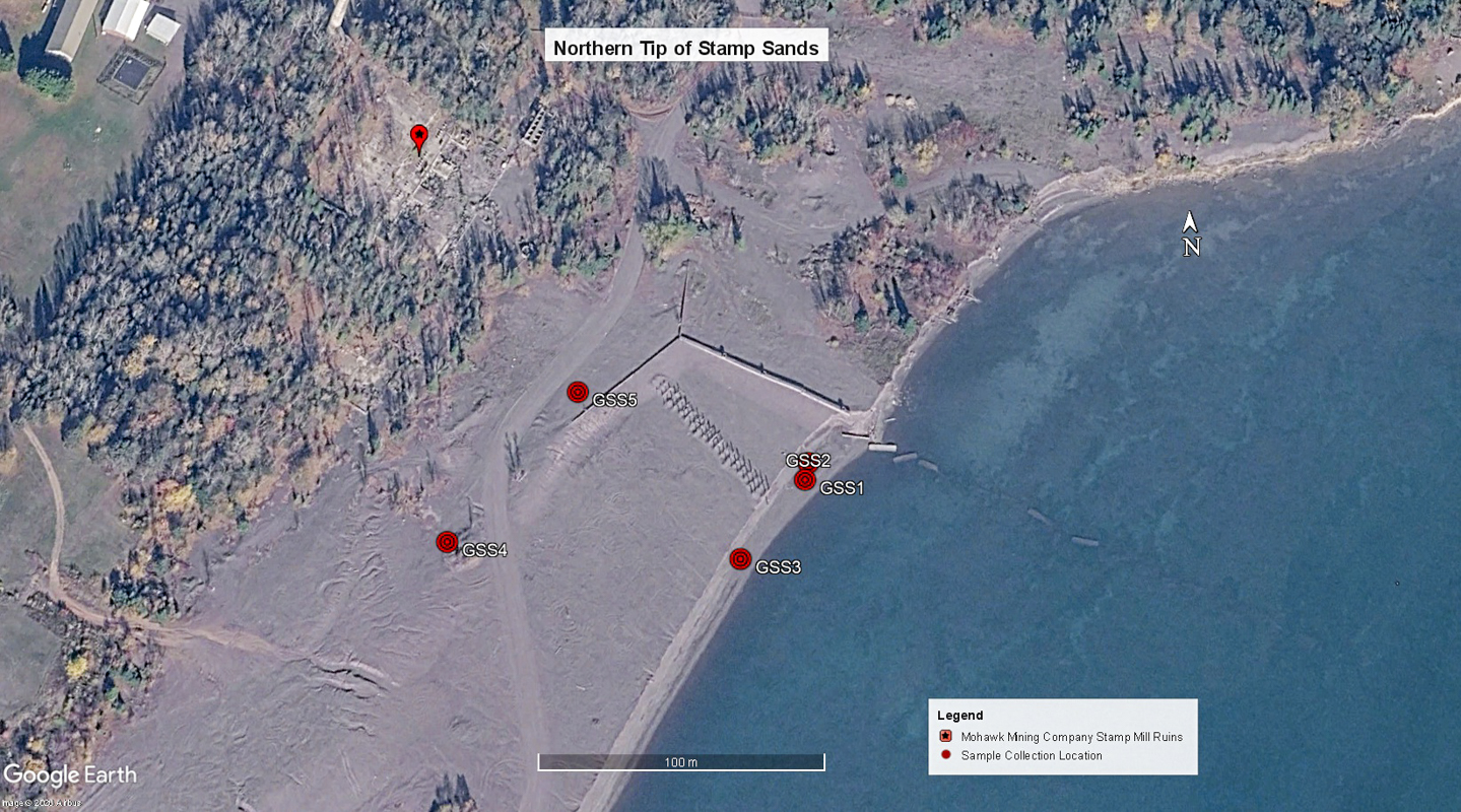
Figure 3. Stamp sands sample collection locations at the Gay former mills site. GSS1 and 2 were from the beach area for composition and grain size/sorting analysis. GSS3 and GSS4 from areas subject to wind-blown size-sorting and composition (e.g., GSS4 from wind deposit in wind-shadow of fallen log). GSS5 is from the coarser sediment clasts found in the back beach area, commonly used currently for off-road vehicle recreation (ATV’s, motorbikes, etc.). This image also provides a good perspective on the submerged concrete sections of the sluice flume that have fallen into the lake as erosion removed the supporting base of accumulated stamp sands. The line of exhumed support posts marks the former path of one of the conveyor systems.
![Figure 4. Surface of the stamp sand deposit. Note that much of the sediment appears coarser than “sand” (granule size), but there are significant amounts of sand, silt and clay. Portions of the tailings pile have a slightly purplish color which Kerfoot et al. (2012) attribute to the iron-oxidized clay fraction. [Penny for scale]](https://coastalcare.org/wp-content/uploads/2026/07/NSS-Figure-4-stanp-sand.jpg)
Figure 4. Surface of the stamp sand deposit. Note that much of the sediment appears coarser than “sand” (granule size), but there are significant amounts of sand, silt and clay. Portions of the tailings pile have a slightly purplish color which Kerfoot et al. (2012) attribute to the iron-oxidized clay fraction. [Penny for scale]
History of Mohawk/Wolverine Mills and Dead Beach Legacy
In 1899 the Mohawk Mining Co. located the initial mine. Construction of the Mohawk Mill began a year later and went into production in late 1901, continuing until closure in 1933. The Wolverine Mill began production at about the same time but closed in 1926. By 1902 stamp sand disposal at Gay was underway at both mills, and by 1907 (Figure 5) the transport system of a concrete box-like sluiceway for “clay slime” and conveyor belts for transporting coarse tailings lakeward had already built a massive delta-like landform into Lake Superior. A 1920 USACE map (Figure 6) shows the operational layout of the Mills’ waste ‘disposal’ system. By the 1930s the delta’s greatest subaerial extension into Lake Superior exceeded a half mile (Kerfoot, et al., 2012). However, when the disposal input ceased at the end of the 1930s, lake processes again became dominant, and waste accumulation was replaced by rapid erosional retreat of site’s shoreline. This shoreline retreat continues (~26 ft/yr, Keweenaw County Historical Society, 2025), undercutting segments of the old concrete sluiceway and re-exposing portions of the conveyor belt structure (Figure 7 and 8). The resulting wave-cut scarp exposes the stacked beds with sedimentary structures such as cross-bedding that indicate the sediments from the sluiceway and conveyor belts were water-laid and/or reworked by currents and waves (Figures 8 and 9). At this location the active beach has a distinctive green color (Figure 10). Although less than 14% of the original waste mass remains at the disposal site, the deposit is still a source of toxic waste as it has been for the last century.
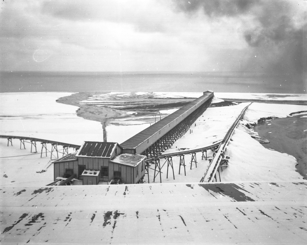
Figure 5. 1907 photo of the mills’ waste sediment disposal system showing sediment fans. In the center of the photo is the long concrete box-like flume structure that carried fine sediments (slimes) and boiler slag to the shore, and on each side conveyor belts that moved ‘sands’ into Lake Superior. Note the merging delta-like fans at the ends of the sluiceway and belts. As the emergent sand pile grew, the waste distribution system was extended lakeward, accreting a new shoreline up to over a half mile offshore. Remains of the flume and the north-side conveyor-system pilings still mark the Gay shoreline.
(Photo courtesy) of the J. Robert Van Pelt and John and Ruanne Opie Library, Michigan Technological University, Archives and Copper Country Historical Collections, MS042-050-999-U914C, http://www.mtu.edu/library/archives)
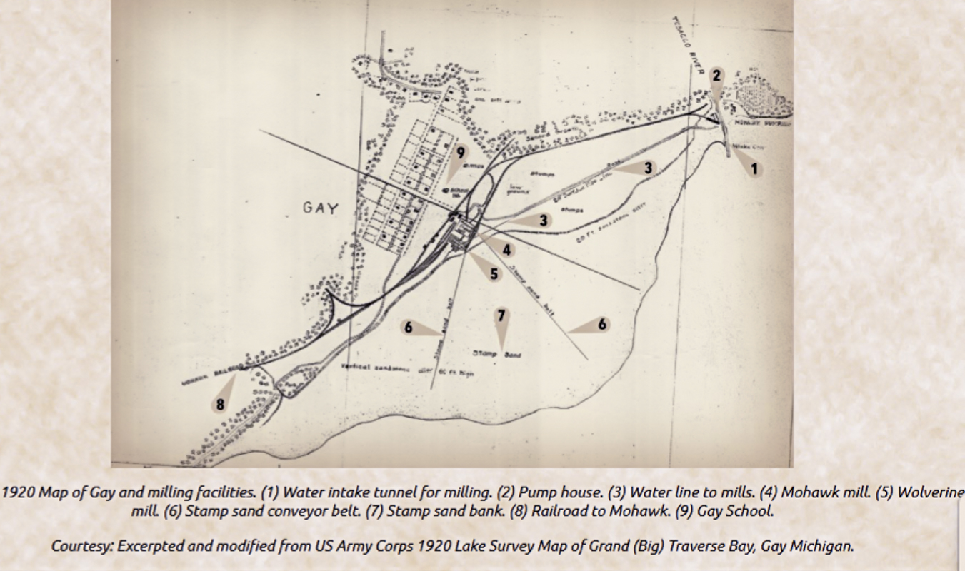
Figure 6. Map (1920) of the town plat of Gay and the Stamp Mill facilities: 1) water-intake tunnel for milling, 2) pump house, 3) water line to mills, 4) Mohawk Mill, 5) Wolverine Mill, 6) stamp-sand conveyor belts to lake, 7) area of accumulated sand bank, 8) railroad to Mohawk, and 9) Gay school. This modified map is from the U.S. Army Corps. 1920 Lake Survey Map of Grand (Big) Traverse Bay (Keweenaw Historical Society, 2025).
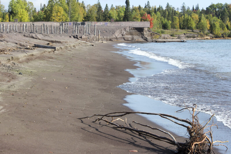
Figure 7. Eroding shoreline (2024) undercutting a segment of the concrete sluice tunnel (slime slurry) and exposing the formerly buried support posts of one of the old conveyor belts (stamp sand transport).
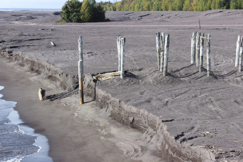
Figure 8. The wave-cut scarp near the exhumed posts of the old conveyor belt track has a vertical exposure of approximately 6 feet, providing a window to see cross-sections of the bedding and sedimentary structures in the water-laid waste deposits (See Figure 9).
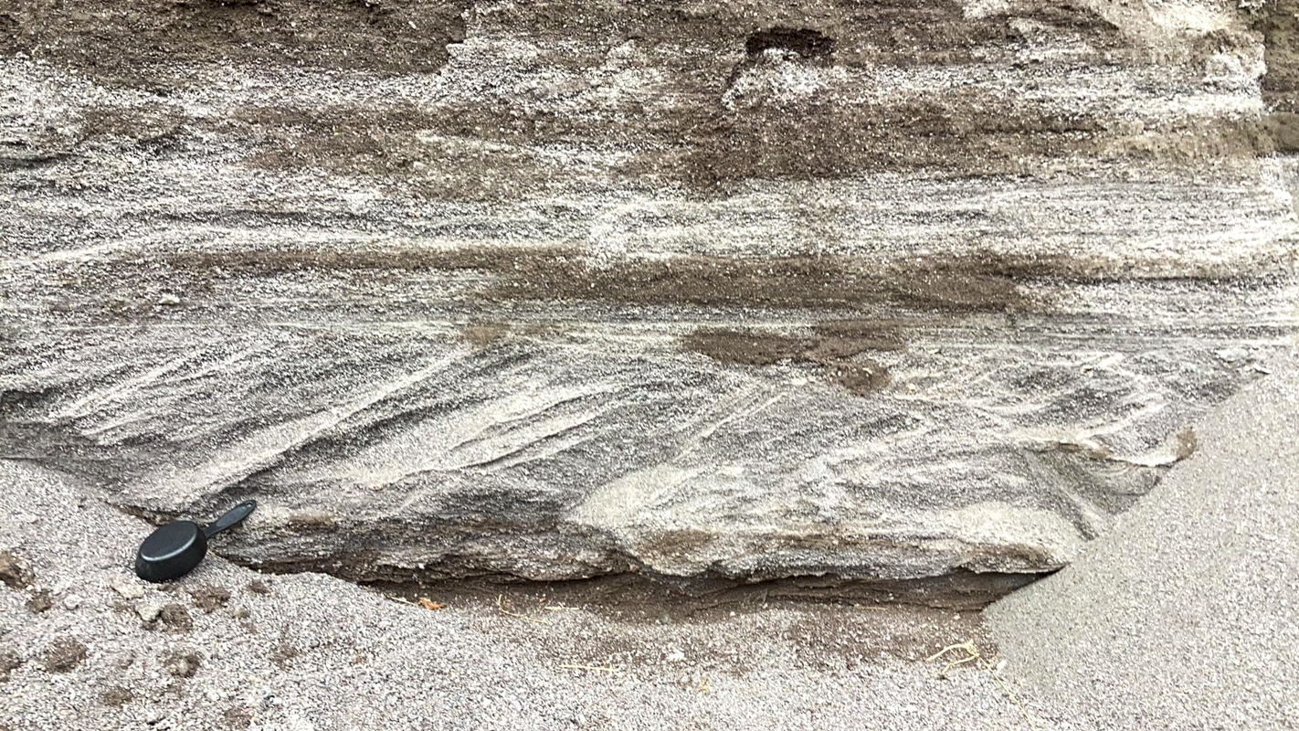
Figure 9. Close up of the wave-cut vertical scarp at the back of the beach showing bed forms in the original sluice deposit. Both horizontal beds with internal horizontal laminae (upper) and cross-bedded layers (lower) are common, reflecting the delta-like depositional conditions as the sluice sediments accumulated. Sampling cup for scale is 7.5 in (19.5 cm) in length.
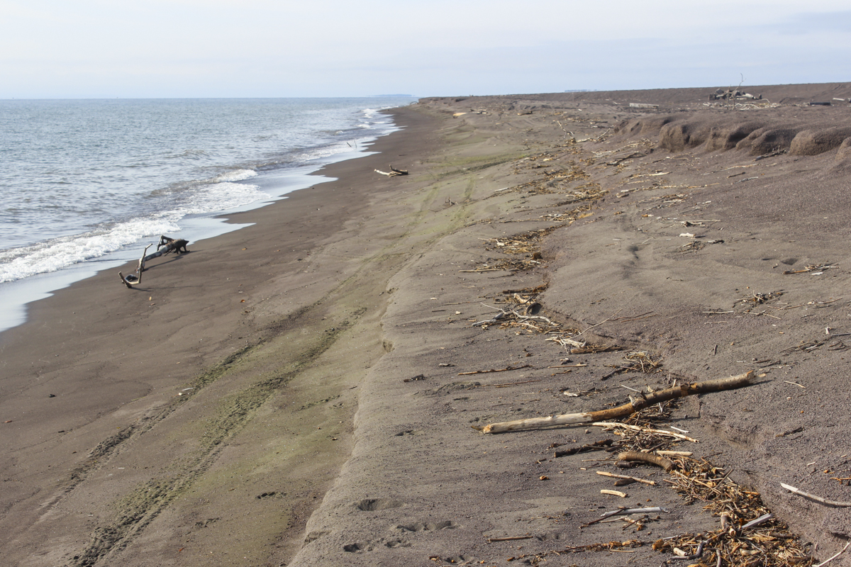
Figure 10. View south from a point downdrift of sample site GSS3 (Figure 3) showing the peculiar green color of the lower wet beach. The size-sorting of the wave swash has concentrated fine sand to clay sized sediment with concentrations of green minerals (e.g., epidote, chlorite, copper oxides). This view provides a good example of how to read indicators of past events on the beach: the scarp in background and right is from the last big seasonal storms of months ago, the woody debris lines are from the most recent storms of days ago, another mini-scarp between the upper beach with footprints and the green sand strip is from the most recent high energy waves, and the green section is from the current wave swash, partially erasing the ORV tracks.
Kerfoot et al. (2012) presented a summary table of the annual discharges of stamp sands into Keweenaw Bay from these two mills, as well as the Mass Mill, compiled from company records in Copper Country Archives. A total of at least 22.7 million metric tons of stamp sands were deposited between these two mills at Gay and the Lake Superior shore. By 2008 only about 3.1 million metric tons remained where initially placed (13.5% of original mass) – the greatest part of the original deposit having been moved offshore (approximately 44% of the original mass, Kerfoot et al., 2012), and downdrift as an evolving beach system — widening and extending to the jetties at the mouth of the Traverse River (Figure 2). Sediment redistribution by longshore currents and storm waves has been at work for decades, building offshore sediment deposits and transporting beach sediment to the south – burying the natural beach and sand bars. Since that time (1932) the shoreline in the immediate area of the original disposal site has retreated half of its original subaerial width as sediments continue to be redistributed – ever enlarging their area of negative impacts. Downdrift, the new stamp sand beach widened, sometimes forming headland-like extensions from which large Spits formed and grew in front of the earlier beach (Figure 11). Spits grow with finger-like extensions that extend landward and attach to the beach, sometimes forming newly isolated ponds.
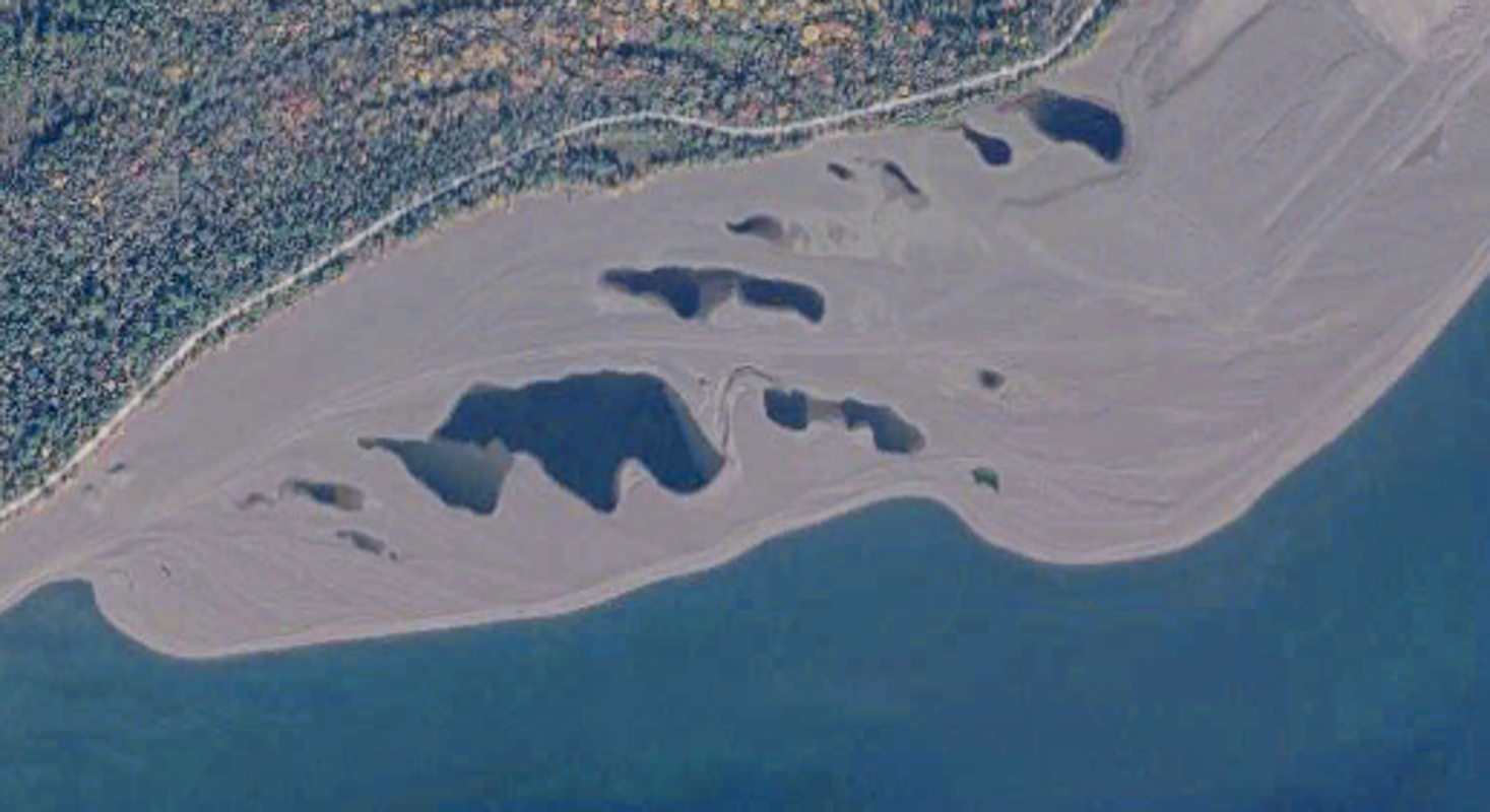
Figure 11. The distinct active Spit feature has formed on the downdrift end of one of the widest areas of the stamp sand beach which acts as a headland. Longshore beach drift around the point forms the growing spit at intervals from oldest (right) to youngest (left). The head of the spit ultimately attaches to the beach it fronts with trapped ponds forming between the “fingers.” The ponds near the road in upper right part of the image are from an earlier spit’s development. Spit formation/attachment is one way in which the beach mass widens. (Enlargement from Figure 2).
The landscape of the resulting beach coast is a barren, lifeless, contrast to the natural beaches of the Great Lakes (Figures 12 and 13). Although the stamp sands have been exposed for decades, revegetation has not occurred. The stamp sands ultimately reached Traverse River jetties which were built between 1949 and 1951 and accumulated as fill behind the north jetty. During storms, waves over-top this jetty, transporting sand into the river channel, requiring periodic dredging of the river mouth for open navigation. In October of 2017 a massive storm caused the sands to over-top the jetty as well as transporting sand onto home lawns at the back of the beach (Ellison, 2022).
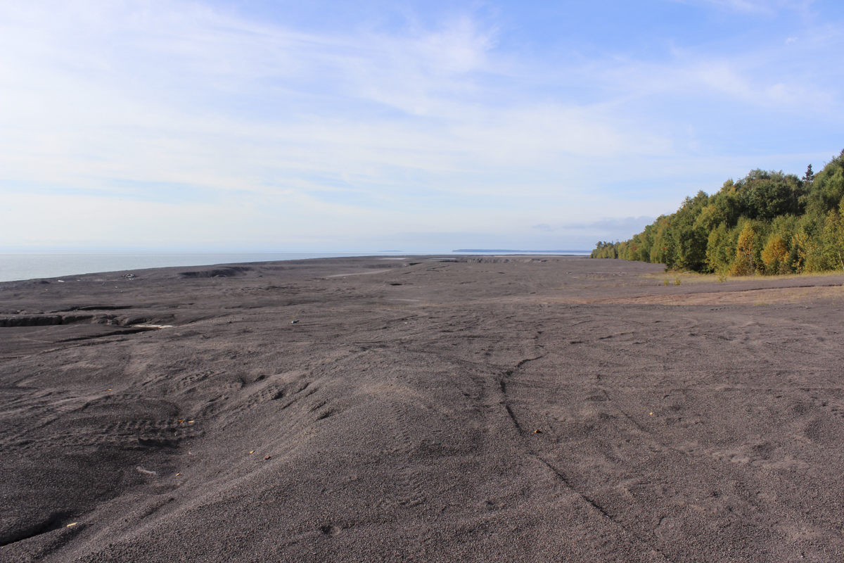
Figure 12. The stamp sand beach in area of spit-widening is typical of the entire length of the landform from Gay to the Traverse River jetties – barren, lifeless, marked by an irregular surface of the remnant spit topography, some man-made excavation pits, and the tracks of the last visit by ORVs. Note that the original accumulation began at about the present tree line although initial over-wash of stamp sand into the forest probably altered plant growth. On a natural Great Lakes beach with this extent of exposure there would have been plant colonization by pioneer plants and a progression to trees.
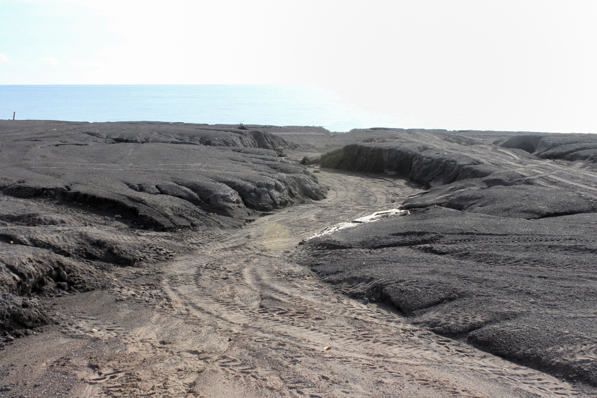
Figure 13. Flooding from landward runoff has cut a channel across the stamp sands, suggesting there is enough clay content to retard infiltration. The tire tracks suggest it’s a fun ORV drive. Location is in the northern portion of the original deposit shore. (See Figure 3, lower left where the drainage pattern extends across the back beach.)
General Nature of the Stamp Sands Composition
The composition of these stamp sands (gangue minerals and sand to gravel sized rock fragments) reflects that of the source rocks and minerals of the Portage Lake Volcanic Series and related hydrothermal mineral deposition. The sand to fine- gravel sized rock fragments include basalt, andesite, and some minor rhyolite, all of which were commonly either porphyritic or amygdaloidal in nature. The Mohawk Mine was located on a copper prospect that was particularly enriched in arsenic, lead, and nickel, so finding these elements in stamp sands that came from this mine is to be expected. The mine is where the minerals Algodonite and Domeykite, two arsenic sulfides, were observed as an ore, originally called ‘Mohawkite’. Thus, in addition to copper, the existence of arsenic, lead, and elevated quantities of nickel and other heavy metals can be explained by the source-rock composition for the ore being processed. Along with the copper and these other heavy metals derived from the stamp sands, elevated levels of arsenic, lead and nickel are common in the sands and associated waters. All are toxic to organisms, and therefore of great environmental concern. These toxic metals have been entering the hydrosphere/biosphere from these tailings as leachate for a Century.
As with most mining for metals, the amount of copper in these ore-bearing rock is a very small percent of the total mined rock. Most mined material is waste (gangue minerals and rock fragments). The Gay beach is this type of waste from the ore processing as noted above in which copper bearing rocks were crushed, and tremendous amounts of gangue material were dumped onto the beach and into the nearshore of Lake Superior. The composition of the stamp sands is dominated by sand-sized rock fragments with lesser amounts of common gangue minerals such as feldspars, calcite, quartz, epidote, and clay-sized minerals such as chlorite and various zeolites. Unfortunately, other metals and elements are commonly associated with these copper deposits. In addition to the copper, arsenic, lead, and nickel, Gay sands include aluminum, chromium, cobalt, manganese, and zinc, at levels exceeding state water quality safety standards (Keweenaw County Historical Society, 2025; Larson et al., 2025).
Even in terms of economic recovery, no mining operation is 100% efficient in recovering the target minerals, or the specific metal. So, in the stamp sands, native copper and copper-bearing minerals remain both as solids and in solution as the dominant toxic element in waters impacted by the stamp waste.
Although Sulfides are found very rarely in the Keweenaw Peninsula, here the presence of sulfide minerals is indicated on the exterior of basalt grains, identified by an iridescent sheen of the grains. The inference is that free sulfur ions come in contact with, and bind to, heavy metals within the basalt, leaching them out and creating the sheen. From the time of precipitation of the sulfide, wave and wind action erode these sulfides and carry them to further infiltrate the hydrosphere (i.e., the lake, inland waters, groundwater).
In the offshore waters, suspended sediments, and accumulated bottom sediments, these toxic metals account for major environmental problems including reduction in the numbers and variety of invertebrates, disruptions in the food chain, loss of fish spawning grounds impacting the indigenous fishing economy and recreational tourism, and an increased threat to human health (Larson, et al., 2025; Kerfoot, et al., 2019, 2023, 2025).
Stamp Sand Beach vs Natural Sand Beach
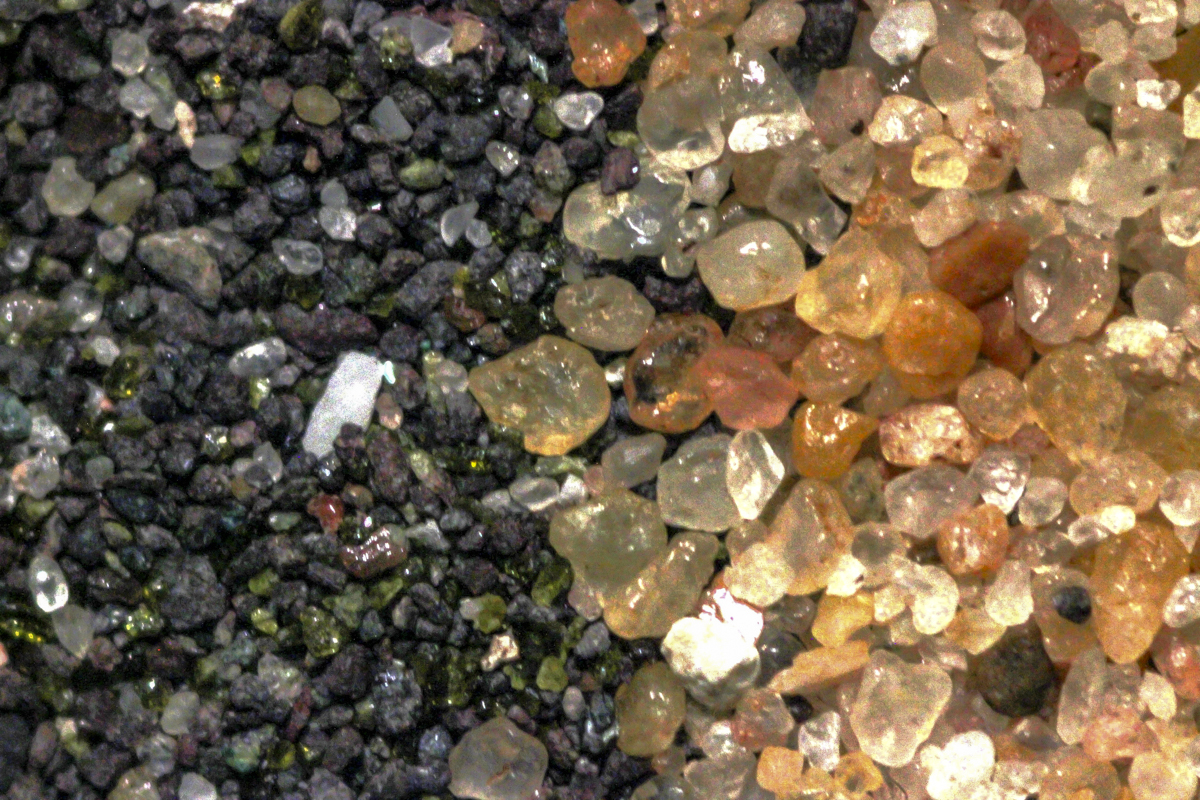
A stamp sand beach might be considered normal in the sense of the same processes and sediment sizes as in the pre-existing natural beach. But in terms of a natural ecosystem, the stamp sand beach is Dead – a living dead or Zombie Beach. The differences range from field overviews to microscopic comparisons. To appreciate the impact of beach loss at Gay, start with the contrast of the beaches on either side of the Traverse River jetties to see the sharp differences in the color of the two beaches, and the absence or presence of vegetation on the back beach (Figures 14 and 15). Walk on the beach south of the jetties and note the quartz-rich sands appear almost golden, and the bedforms of swash marks, sand holes, and cascading sand on the dune scarp face (Figures 15 and 16). These features are typical of any active beach, but this beach is a toxic-free, natural system (at least until significant amounts of the stamp sand by-pass the jetties or come onshore). Compare handfuls of sand from the contrasting beaches and the compositional and size differences are apparent (Figure 17). The differences in mineral composition are even more striking in a microscopic comparison: the dark sand-sized rock fragments and some green grains vs the dominant quartz grains of the natural beach (Figure 18).
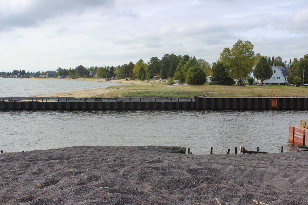
Figure 14. Foreground is stamp sand surface of the buildup behind the north jetty. Beyond the river mouth is the natural beach, widened and vegetated with grasses next to the south jetty indicating some seasonal sand transport to the north. A healthy stand of trees and village houses with recreation amenities are what could have lined the entire shoreline from here to Gay.
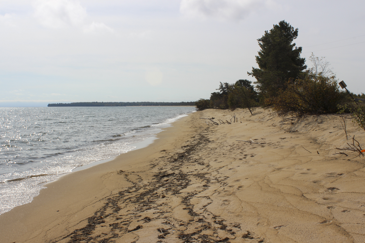
Figure 15. The natural beach extending south of the Traverse River Jetty. Some studies report the original beach in the Gay area as white, but the yellowish to almost golden color seems more typical. The dominant mineral grains are quartz, but most have an iron-oxide coating or stain that gives the yellow to tan color.
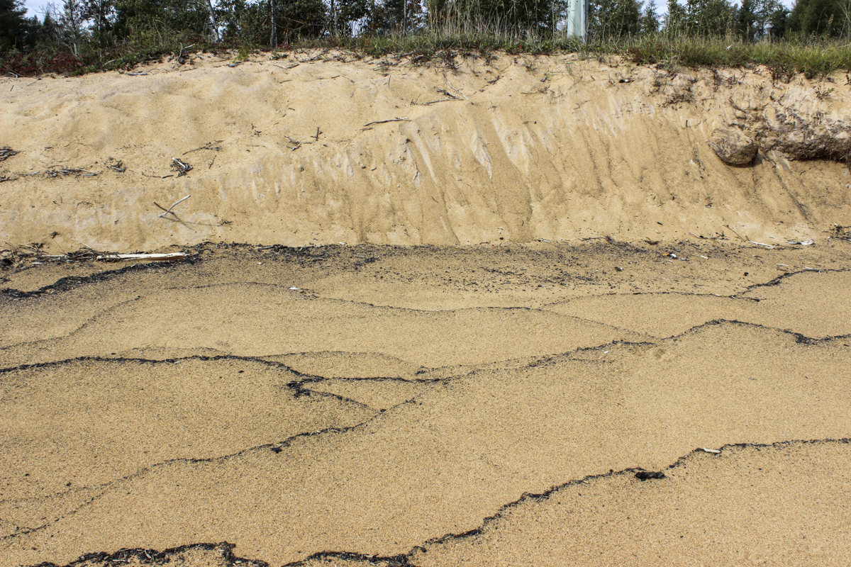
Figure 16. Surface of the natural beach south of the Jetty shows typical beach features such as swash marks, and tiny sand holes. Escaping air and water from beach deposition causes the latter. The distinct swash marks are concentrations of organic matter that was transported landward by each individual wave swash and deposited where the swash dissipated. At the back of the beach, the eroded face of the dune deposit shows evidence of sand-flows down the scarp face.
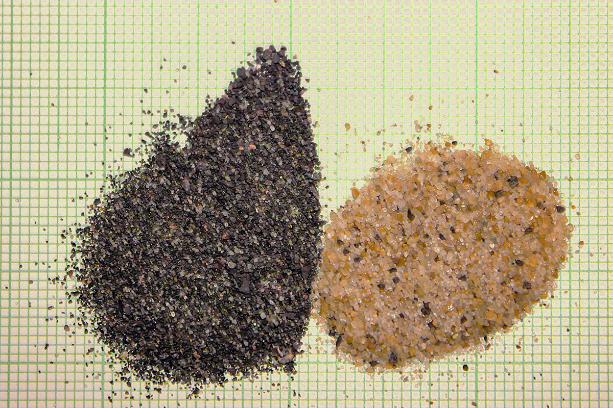
Figure 17. Photo of stamp sand (left) and natural quartz-rich beach sand (right) on mm-grid paper. Note that the black stamp sand is more poorly sorted in grain size (silt to granules), dominated by the dark colored crushed ore with only a trace of quartz and pink feldspar. In comparison, the natural beach sand sample, taken from just south of the jetties, is dominantly quartz (both clear and yellow-stained grains), moderately size sorted, with some black grains of stamp sand; evidence that the stamp sand is bypassing the jetties.
Figure 18. Microscopic view comparing the poorly sorted, dark colored stamp sands on the left with the natural, moderately well sorted, quartz dominant sand on the right. The dominant stamp sand grains are sand-sized rock fragments, plus some green grains and a trace of quartz. The natural sand is almost entirely quartz, mostly subrounded to rounded, either clear or pinkish/tan from surface staining.
The Gay Stamp Sand Beach Dilemma
Thinking in terms of just the Gay beach problem, proposed Solutions to restore a more natural shoreline fall into three categories:
Removal: Some sediment has been removed to use as gravel-road aggregate. And limited amounts of the stamp sand were moved to the landward side of the beach. The latter was intended to bolster protection of property against storm-waves, but the sediment remains as part of the original mass, so nothing was accomplished. The October 2017 storm submerged the beach and crossing waves carried surface sands into the yards of houses behind the deposit. The question remains – where to put removed sediment? At one point in time, mills deposited waste sands in lakes and inland waters (e.g., Torch Lake), but that only widened this environmental disaster (now part of the regional study seeking solutions). In short, removal would be most costly economically, and least feasible, extending the pollution hazard to other areas.
Reuse: Reusing removed material might solve part of the secure storage problem, but this is unlikely to reduce more than a small portion of the stamp sand volume above lake level. Borrow pits have resulted from small quantities of the sediment being mined for use on local gravel roads. Such use gives new meaning to the term “road metal,” given that the material still has the same copper, arsenic, and other toxic metal contaminants, now dispersed over a greater area. Dust generation off such roads will spread the pollutants inland. The same is true in the proposed use of stamp sand for aggregate in concrete. Although diluted, the culprit is not eliminated, only relocated. A similar proposed use that was tested as being feasible is to mix stamp sand aggregate with acrylonitrile styrene acrylate (ASA) plastic waste which when heated to a high temperature forms a binder, generating a substitute for asphalt (Dongzhao, et al., 2022). Although this sounds like a win-win solution, getting rid of two pollutants for a useful end-product, the end-use results are the same. Road pavement breaks down, and the binder can become a source of microplastics release, while the stamp sand aggregate still contains the polluting metals that will be released through wear. Again, the problem is moved elsewhere in a form that can’t be contained.
Containment: Stabilizing the mass requires holding the three-dimensional deposit in place and sealing both the lake shore-face and the surface of the mass. A low-permeability clay cap on the surface, and revegetation, may be feasible, but to seal the wave-cut bluff would require an impermeable seawall which is counter to a natural beach reforming. The coastal reach would be beachless or require artificial beach nourishment (offshore sand deposits also are accumulated stamp sands, unsuitable for such nourishment). A small-scale containment project appears to have been successful over the short term at Sand Point in Keweenaw Bay for an area buried by stamp sands from the Mass Mill.
The Broader Problems
Using a natural beach as a dump site, even for processed sand-sized sediment, results in immediate to continuing down-drift beach loss. But additional impacts are even more far-reaching in terms of associated environmental and sequential land-use losses, both in space and time. In the case of the Gay Stamp Sand the concerns center around toxic contamination of Lake Superior in terms of water and sediment, and the impacts of the fine-grained silts and clays that settle onto (and into) Buffalo Reef (Figure 19). The term “reef” in the Great Lakes refers to raised areas on lake bottoms that consist of fields of coarse sediments (mainly cobbles, but from boulder to pebble sized) that are the breeding grounds of various fish species, and the small invertebrate organisms that are fish food. These losses are on-going, particularly to Buffalo Reef, and are documented in numerous journal articles, and reports on studies seeking viable solutions to mitigating the problems. These studies are the result of co-operation between numerous federal, state and local agencies. The reader is referred to the “Buffalo Reef – Final Alternatives Analysis” (Buffalo Reef Task Force, 2024) for an in-depth report that examines the problems and the intractable solutions to this eco-disaster. What was dubbed a “$1billion eco-disaster” in 2022 is looking more like 3 times that number in 2026.
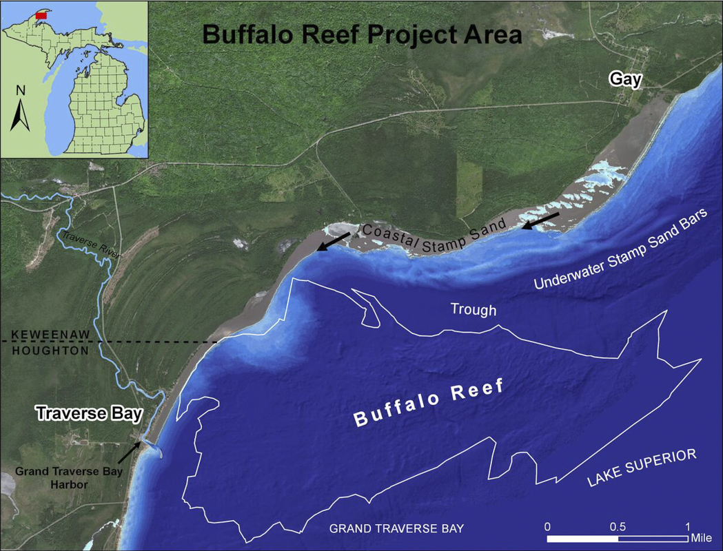
Figure 19. Michigan Department of Environment, Great Lakes, and Energy (EGLE) map of the Buffalo Reef project area. The stamp sand deposits continue to have significant negative offshore impacts as well as the original beach destruction. Buffalo Reef, an approximately 2,200-acre spawning ground for whitefish and lake trout that has supported an important fishing industry as well as supporting a diverse invertebrate fauna, is being buried by stamp sands, particularly fines, carried offshore. The subaerial Gay beach is highlighted along with arrows indicating dominant longshore transport directions. Note there are significant volumes of stamp sands offshore (sand bars and fill in trough). Note too, the apparent terminus at the river mouth jetties at Grand Traverse Bay Harbor.
Epilogue
We would like to think that the Michigan stamp sand pollution sites are from olden times when environmental impact was poorly understood; when there was little concern of mining impacts on the Indigenous Peoples culture; and when no thought was given to the fact that ore deposits are limited/nonrenewable resources and that boom towns would go bust when the mines petered out. Yet the same scenarios persist at present. W. Charles Kerfoot et al. (2012, 2023) document selected global examples of large discharges from legacy mines into global coastal environments (e.g., mine tailings, mill sluicing, and holding-pond dam failures). They list 14 sites from 9 countries (13 of which conflict with rights/lands of Indigenous Peoples) that are indicative not just of past pollution but also are generating major ongoing problems into the future.
We have seen the same from sand mining of beaches, dunes, river channels and floodplains – where local populations lose clean water sources, fisheries, farmland, and cultural sites without any compensation or post-mining restoration. And history does repeat itself. By 2025 new mining operations were proposed for Minnesota (copper-nickel-platinum group), Wisconsin watersheds to Lake Superior, and Michigan (Copperwood Mine with a proposed 320-acre basin to hold the mine tailings). A significant reach of Canada’s Lake Superior shoreline and watersheds are held in mining claims and are under active exploration. Before any of these projects proceed, the mining companies and our regulatory agencies must step up to their legal and moral obligations to protect ecosystems and the rights of all stakeholders including renewable resources, indigenous peoples’ culture, property owners, and the public domain in terms of protecting the Great Lakes and their respective drainage basins.
References
Buffalo Reef Task Force,2024, Buffalo Reef – Final Alternatives Analysis. ENGLE, MI 226p. https://www.michigan.gov/dnr/-/media/Project/Websites/dnr/Documents/Fisheries/Archive/BuffaloReef/00-Buffalo-Reef-Main-Report-2024-ADA.pdf
Dongzhao, J., Meyer, T.K., Chen, S., Boateng, K.A., Pearce, J.M., and Zhanping, Y., 2022, Evaluation of lab performance of stamp sand and acrylonitrile styrene acrylate waste composites without asphalt as road surface materials. Construction and Building Materials, 338, 127569. https://doi.org/10.1016/j.conbuildmat.2022.127569
Ellison, G., 2022, On Lake Superior, a $1 billion eco-disaster is swallowing the coast. M Live Newspapers. https://www.mlive.com/public-interest/2022/06/on-lake-superior-a-1-billion-eco-disaster-is-swallowing-the-coast.html
Kerfoot, W.C., Harting, J., Jeong, J., Robbins, J.A., and Rossman, R., 2004 Local, regional and global implications of elemental mercury in metal (copper, silver, gold, and zinc) ores: Insights from Lake Superior sediments. Journal of Great Lakes Research, 52, 162-184. http://doi:10.1016/SO380-1330(04)70384-6
Kerfoot, W.C., Yousef, F., Green, S.A., Regis, R., Schuchman, R., Brooks, C.N., Sayers, M., Sabol, B. and Graves, M., 2012, Light detection and ranging (LiDAR) and multispectral studies of disturbed Lake Superior coastal environments. Limnology and Oceanography, 57(3), 749-771. https://doi.org/10.4319/lo.2012.57.3.0749
Kerfoot, W.C., Hobmeier, M.M., Regis, R., Raman, V.K., Brooks, C.N., Shuchman, R., Sayers, M., Yousef, F., Reif, M., 2019, Lidar (light detection and ranging) and benthic invertebrate investigations: Migrating tailings threaten Buffalo Reef in Lake Superior. Journal of Great Lakes Research, 45(5), 872-887. https://doi.org/10.1016/j.jglr.2019.07.009
Kerfoot, W.C., Hobmeier, M.M., Swain, G., Regis, R., Raman, V.K., Brooks, C.N., Grimm, A., Cook, C., Shuchman, R., Reif, M., 2021, Coastal Remote Sensing: Merging Physical, Chemical, and Biological Data as Tailings Drift onto Buffalo Reef, Lake Superior. Remote Sensing, 13(13), 2434. https://doi.org/10.3390/rs13132434
Kerfoot, C., Swain, G., Verissimo, L., Johnston, E., MacLennan, C., Schneider, D., and Urban, N., 2023, Coastal Environments: Mine Discharges and Infringements on Indigenous Peoples’ Rights. Journal of Marine Science and Engineering, 11(7). http://doi.org/10.3390/jmse11071447
Kerfoot, W.C., Swain, G., Regis, R., Raman, V.K., Brooks, C.N., Cook, C., and Reif, M., 2025, Coastal Environments: LiDAR Mapping of Copper Tailings Impacts, Particle Retention of Copper, Leaching, and Toxicity. Remote Sensing, 17(5), 922. https://doi.org/10.3390/rs17050922
Keweenaw County Historical Society, 2025, Copper Milling at Gay: a Lake Superior story. Ten-panel summary of the history of the Gay village area from geology to copper discovery, milling, and subsequent evolution of the once boom-town to the legacy bust of pollution. https://keweenawhistory.org/Copper-Milling-At-Gay
Larson, J.H., Lowe, M.R., Bailey, SW., Bell, A.H., Cleveland, D.M., 2025, Effect of copper mill waste material on benthic invertebrates and zooplankton diversity and abundance. PLoS ONE, 20(3), e0318980. https://doi.org/10.1371/journal.pone.0318980
National Park Service, 2025, Environmental Impacts of Mining in the Keweenaw. Environmental Impacts of Mining in the Keweenaw – Keweenaw National Historical Park (U.S. National Park Service)
Pilkey, O.H., Longo, N.J., Neal, W.J., Rangel-Buitrago, N.G., Pilkey, K.C., and Smith, H.L., 2022, Vanishing Sands: Losing Beaches to Mining. Duke University Press, Durham, NC., 248p