


By Chester W. Jackson Jr., Ph.D, Assistant Professor of Geology, Georgia Southern University and Carol Ruckdeschel, The Cumberland Island Museum, St. Marys, Georgia.
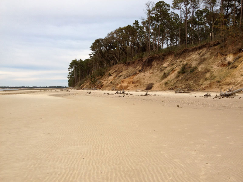
With a barrier island shorescape composed of kilometers of dune ridges, expansive maritime forest, and dynamic shorelines, Cumberland Island is a complex landscape fashioned by natural processes intertwined with a history of human and non-native biological impacts. Cumberland Island is the largest (28.5 km long) and southernmost barrier island along Georgia’s coast and has a geologic framework composed of Holocene sediments mostly along the oceanfront region welded to a Pleistocene paleobarrier. The Pleistocene core of the island contains some of the highest elevations of the Georgia coast and ranges from 8 to 10 meters high in areas within the northern half of the island. Migratory Holocene dunes exceeding 10 meters can be found along southern and northern areas of the island. The recreational beach is generally tens of meters wide and fronted with well-developed ridge and runnel topography exposed at low tide. The backbarrier shoreline is composed of a mixture of dense to moderately vegetated dunes and sediment banks, maritime forest, and marsh platforms.
Although most of Cumberland is undeveloped and managed by the National Park Service, there are a number of issues concerning the impacts that human activity and non-native species are having on the coastal landscape. One of the most notable changes to the coastal landscape is rapid shoreline accretion that has taken place along the oceanfront following the emplacement of a jetty at the south end of the island in 1882. Since the emplacement of the jetty at St Marys Inlet, the adjacent updrift shoreline along Cumberland advanced seaward approximately 1.6 km at a rate of 10.8 m/yr based on the current position of the shoreline in 2012.
Although most of Cumberland is undeveloped and managed by the National Park Service, there are a number of issues concerning the impacts that human activity and non-native species are having on the coastal landscape…
—Chester W. Jackson Jr and Carol Ruckdeschel
At first glance, the addition of a large area of sand along Cumberland’s oceanfront near the southern end appears to be a great situation for the island, however, modifications to the inlet system are likely enhancing rapid shoreline erosion along the backbarrier shoreline adjacent to the inlet. Erosion rates increased along the backbarrier from the Dungeness Dock/Wharf southward toward the jetty since 1882. Engineering and dredging within St Marys Inlet, coupled with the construction of a seawall along the wharf area, enhance erosion along the backbarrier shoreline. The Dungeness shoreline along the southern end of the island is one of the fastest eroding backbarier shorelines along the Georgia coast with erosion rates exceeding 1.5 meters per year in places. Erosion now threatens cultural resources managed by the NPS and is likely further enhanced by grazing activity of feral horses and hogs on the island, especially along salt marsh shorelines. The salt marsh suffers enormous damage from feral livestock. Heavy animals, such as horses, churn and chop the stabilizing marsh cordgrass, turning the area into a quagmire.
During the time of free-ranging cattle, the understory on Cumberland Island was greatly reduced and presented a park-like appearance. The cattle spent much time on the beach to escape biting insects and there eliminated the typical interdune Wax Myrtle habitat by keeping the myrtle bushes browsed to 30-45 cm (1-1 1/2 feet) in height. They also consumed other dune stabilizing vegetation which frustrated normal dune dynamics. Blowing sand was stopped by the inland tree line, but there was nothing to stop it between there and the ocean, so the system was greatly compromised. On the south end of the island where accretion was predominant due to the effect of the jetty, primary dunes were lacking and unable to become established because of the lack of vegetation. This precluded use of that area by sea turtles, and it was not until several years after the cattle were removed that the beach on the south end was suitable for sea turtle nesting. With a 15 to 25 year maturity period, and young returning to their natal beach to nest, only recently has the island sea turtle nesting distribution begun to equilibrate between the north and south ends. In the 1970s there was rarely a nest from Willow Pond Rd. South.
Today, the movements of the shoreline and adjacent coastal features, especially noticeable along the southern portion of the island can be linked to vehicle and foot traffic in addition to grazing and trampling by horses and other non-native feral animals. Some visitors consider the horses to be part of the charm of Cumberland, however, they are a destructive force to the island’s natural landscape. However, the main attraction of Cumberland Island is its rich coastal landscape that attracted visitors long before horses, hogs, and armadillos arrived on the island.


