


By Cecelia Dailey,
From the south, the route to the ancient city of Cadiz moves through rolling hills lined with windmills, then miles of estuary and flooded fields along the Andalusian coast of Spain. Abandoned and living mouths of alluvial rivers deposit sediment to the ocean and along the shore here. In the Gulf of Cadiz, rich marshlands flourish. But the city of Cadiz is different—it is built on what was once a rocky archipelago, now a half-mile wide peninsula. Sand, silt, and other sediment deposited over the last 6500 years have filled the space between the islands, allowing successive cultures room to expand. [1] A narrow strip of land only wide enough for a road and beach connects the peninsula of Cadiz to the south. At the peninsula’s northern end is the unique fan-shaped city of Cadiz. [2] Though it faces the waves of the open ocean, Cadiz has persisted through storms over the centuries and is one of Europe’s oldest cities. Changing geography has shaped the seafaring cultures that made their home here, and in turn, its people have shaped Cadiz into a fortress of a city that is inflexible to the dynamic coast.
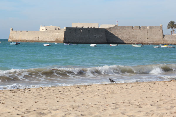
Beloved by locals and tourists alike, La Caleta is the only open beach in the walled city of Cadiz. A boardwalk forms the border between the beach and city; an adjacent cafe is good vantage point for watching people play and pick up stones on the shore. Central to the 360-meter long beach is a white pavilion raised above the sand on pilings. On each side of the beach, two ancient reef structures extend into the Atlantic, calming the waters of La Caleta’s harbor. Acting like two straight jetties, the fossil-filled reefs form a channel into the swooping C-shaped beach and shallow bay. Two castles sit atop the rocky outcroppings that border the beach. Connected to the shore, Santa Catalina castle is the beach’s northernmost point. In the distance, San Sebastian castle and its long promenade form the southernmost border of the beach and bay.
Changing geography has shaped the seafaring cultures that made their home here…
—Cecelia
Both of La Caleta’s castles were completed during Spain’s wealthiest age, lasting over 300 years, when trade with the Americas necessitated protection of the city. [3] Though the port is located on the opposite side of the peninsula, the castles served as a strategic point of defense on the Atlantic. Designed as fortification, Santa Catalina was built as a direct response to an English sack that devastated the city in 1596, and by the mid-sixteenth century Cadiz was fortified with essential defensive features such as gates, towers and walls along its perimeter. [4] At that time, Cadiz’s hard-edged outline had taken form, looking much like it does today.
When visiting this past winter, historic photographs, artifacts and maps cataloging early settlements of Cadiz were on display at Santa Catalina castle—today used as an exhibition and event space. Charts and drawings shown are from a 1982 archaeology study by J.R. Ramirez, who now heads the city’s history museum. [5] According to the exhibition text, there was no such beach at La Caleta in the past, but between the reefs of La Caleta was the Canal Bahia-Caleta, or Bay-Cove Canal. If it existed today, the canal would cut through the modern-day city and connect to the port-side of Cadiz.
In the model displayed, the land is divided into three major islands by the canal, with many small islands along its rocky outcroppings. Part of the Bahia-Caleta was detected in 1926 by a mining engineer named Juan Gavala y Laborde who suggested it was an ancient river mouth. [8] The canal was renamed the Canal de Ponce for the author of the 1976 study that confirmed its existence below the city. [1]
A windy outcropping jutting into the Atlantic, where San Sebastian castle sits today, is depicted in a colored etching at the exhibition (Braun & Hogenberg, c. 1598). It shows fishermen out on rocks, a wall along the shore, and quarrying in the harbor at La Caleta adjacent to a chapel. The medieval chapel was dedicated to Sebastian, the saint said to protect from plague—in the image, a white-robed Catholic clergyman (holding a rosary) faces a man in black, presumably death. There is evidence of an earlier Punic-era shrine at San Sebestian’s location too. [5, 6]
From the beach, the 1706 fortification is visible in the distance, connected by a 19th century boardwalk. Possibly the location of an ancient shrine to Kronos, interpreted by the Romans as the god of time, this location has been revered for its poetic and spiritual qualities and provided refuge from the foreboding sea. A feeling about this place persists—to be in Cadiz is to be on the edge of the world.
On display at Santa Catalina was a collection of Roman amphorae, ceramic cargo containers, evidence of Cadiz’s history as a hub for commercial fishing and trade. Some amphorae date from the Punic times, when Phoenicians, Cadiz’s earliest known inhabitants (c. 7th or 8th century BC) used La Caleta as inlet to an interior port at a time when the area was divided into islands [9]. Evidence of a port in the canal has been shown by Oswaldo Arteaga, J. R. Ramirez and others. [1,5] Sometime during antiquity, the port was most likely moved to the gulf-side (west coast) of Cadiz because the Bahia-Caleta was filling with sand making navigation difficult. Today, small wooden boats float in the bay at La Caleta beach, and at low tide, the boats sit out on rock flats. Although no longer booming, port commerce and fishing industries are still significant to Cadiz’s economy.
Arteaga explains the physical and cultural chronology of this area in his 2008 article included in a volume exploring the geologic history and archaeology of Cadiz. Around 6500 BP (before present), there were many small islands, the Bahia-Caleta canal was open, and there are none or very few marshlands. By 3000 BP (around the time of the Phoenicians), an isthmus formed, bridging the Bahia-Caleta canal and connecting the major islands; the Isla de Cadiz is united with San Fernando (an island to the south), forming a larger landform; the wetlands grew with sediment deposited from rivers. Around 1000 BP, when much of Spain was under Islamic rule, the shape of Cadiz’s old city is recognizable and the channel is filled in. La Caleta beach is the historic site of the canal’s mouth to the west; the port is to the east. [11]
Walking along the beach, weathered rock, rounded stones, and pieces of ancient coral are washed up on the sands of La Caleta and collected along castle walls. Some light umber-colored rough rocks give an idea of what Cadiz is seated on—porous rock, composed of sedimentary sandstone and conglomerates. The castles are made from a brown stone embedded with fossilized shells, and strolling the narrow winding streets of the medieval city, there are many intricately carved facades of the same material. Possibly quarried from La Caleta beach or another site nearby, this is what the locals call “oyster rock” or “piedra ostionera”–a cemented conglomerate rich in shells from the Tertiary age. [12]
For at least the last century, La Caleta beach and the coastline of the Cadiz province have been in recession and many beaches have been artificially restored in order to stabilize them.
—Cecelia
Seated along faults, a series of tectonic events gave Cadiz its peculiar morphology, producing a depression that filled to become the gulf. [13] There are also deposits in the gulf that indicate tsunami activity. [14]
The beaches of Cadiz, said to be among the most beautiful in Spain, have nearby high-rise buildings and structures. Most of the old town, however, lacks such urban density and has open plazas and gardens with tiled walkways and fountains. Cadiz underwent a period of dramatic growth beginning in the 1940s until the mid-70s, focused on building the city as a tourist destination, and included high-rise projects, mostly to the south of the old walled city. [15] On a narrow peninsula like Cadiz, coastal forces are never absent and high-rise buildings are always close the sea.
For at least the last century, La Caleta beach and the coastline of the Cadiz province have been in recession and many beaches have been artificially restored in order to stabilize them. A 1998 Coastal Engineering article reports that: “During the last decade, more than [12 million cubic meters] of sand have been nourished in 38 restoration operations carried out on 28 beaches” in the Cadiz region. La Caleta, about 50 meters wide, is one of the smallest of the Cadiz beaches. 41,440 cubic meters of sand (mixed with silt and shells) was added as beach nourishment material to La Caleta at a total cost of US$81,032 in 1991. Sand used for La Caleta’s nourishment project was sourced offshore from Cadiz’s Cortadura beach, located to the south of La Caleta. Other dredge sites for this region are located in Cadiz’s harbor, facilitating its port and shipping channel.
In the Cadiz province, beaches were nourished between one and three times in the 1990s. [16] Beach nourishment projects around Cadiz have been generally well-accepted by the public and said to have “relatively good performance after more than 13 years” of study. [17] However, when a beach is in recession, nourishment must be repeated to achieve the status quo. Dumping sand on the beach destroys beach life, sand washes away, and dredging rips into seafloor, potentially impacting sea life as well as covered artifacts and shipwrecks. Nourishment gives the illusion that the beach is a static feature—however, erosion is constant, and in a balancing act with forces of sediment deposition, coastal environments are always changing.
Erosion in the Gulf of Cadiz is directly related to dams that prevent sediment from flowing to the sea, according to the 2002 University of Cadiz study. Spanish hydraulic policy in the 1960s through the 90s spurred the construction of dams at many points along the rivers that drain the Andalusian Plain, including the Guadalaquivir, Guadiana, and Gaudalete rivers. Consequently, coastline retreat, low in the 70s, progressively accelerated through the 80s, leading to widespread shoreline erosion. Hardened shoreline structures also contribute to beach loss and shoreline erosion in Cadiz. [18] Rates of erosion on La Caleta, or any ocean-facing beach, vary with the intensity of storms from year to year.
Located at the mouth of the shallow Guadalete River, Cadiz is about 30 miles south of the mouth of the Guadalquivir River, the only large navigable river in Spain. Romans sailed from the Atlantic inland to Cordoba by way of this broad, gentle river, but today, the mouth of the Guadalquivir River is choked by sandbar formation. [19] During the 18th century, these sandbars caused, in part, the Spanish government to shift their trading post from upriver Seville to Cadiz, a testament to the dynamic character of rivers in this region. [3] This area is now the Doñana National Park, established in 1963 to protect the marshy river delta. [20] The nearby Natural Park of Cadiz, a region of wetlands, was established in 1989. [21] Protection of these areas as parks allows their dynamic character not to be impeded upon and complex ecology to flourish along the coast.
No expansion of Cadiz’s border is happening here today, prohibited by Spain’s law governing coastal development. The “Ley de Costas” or “Coastal Law” creates a zone of public domain along the beach, surf zone, areas of historic storm infiltration, and areas reclaimed by the sea. Restricted zones 100 meters inland from the beach allow private ownership only of structures built prior to 1988. [22] The 1978 Spanish constitution considers the beaches to be publicly owned (Article 132). [23] How the law will be implemented in Cadiz in unclear, as much of the city seems to fall under the public zone, and if it faces damage from a storm, rebuilding might not be permitted.
Spain’s law aims to protect and preserve their coast in the most natural state as is possible. Tourism is an essential part of Spain’s economy, especially today, and their coastal laws are an effort to ensure that coastal landscapes are not degraded due to competing interests. Coastal law in Spain has been controversial, and even more controversial has been the enforcement of the law through demolition of illegal construction. [24] With advancing sea level rise, Spain’s plan for its cities to recede from the beach is wise. With much of Cadiz sitting on land protected by hard structures and seawalls, might Cadiz persist another century as a living city or will it become a relic, like the deteriorating artifacts that surround it on the seafloor? As a tourist sitting on La Caleta beach, the scene is peaceful and gentle waves lap the shore.
Google earth map of cadiz with locations of important features marked: Google earth map
For further study of Cadiz’s geography and cultures, one of the best resources is: the No. 10, 2008 issue of RAMPAS (Atlantic-Mediterranean Journal of Social Archaeology and Prehistory) containing 16 articles published in Spanish.
FOOTNOTES:
[1] Oswaldo Arteaga Matute, Geoarqueología y Proceso Histórico en la Bahía de Cádiz. Revista Atlántica-Mediterránea de Prehistoria y Arqueología Social 10.Cádiz: Universidad de Cádiz, 2008.
[2] Google earth map of cadiz with locations of important features labeled: Google earth map
[3] Parry, J. H., The Spanish Seaborne Empire, from The History of Human Societies series.
[4] Port Cities of Atlantic Iberia, C. 1500-1900, Patrick O’Flanagan, 2008.
[5]Ramirez’s 1982 study of its earliest dwellers. JR Ramirez
[6] Sobre la topografía de Cádiz en la Edad Media, Museo de Cadiz.
[7] Puerto Chico Cadizipedia.
[8] The Phoenicians in Spain: An Archaeological Review of the Eighth-Sixth Centuries B.C.E., edited by Marilyn R. Bierling, Seymour Gitin.
[9] “Fish-Salting Plants and Amphorae Production in the Bay of Cadiz (Baetica, Hispania). Patterns of Settlement from the Punic Era to Late Antiquity”, Bernal, D., & Sáez Romero, A. M., 2008.
[11] PROBLEMÁTICA Y SITUACIÓN ACTUAL DE LA ARQUEO- LOGÍA SUBACUÁTICA EN LA BAHÍA DE CÁDIZ, 1998. Read More
[12] ©© Tashland Schmidt, Macau, Figueras, Benjumea, and Goula, 2009.
[13] “Geology in the vicinity of the city of Cadiz”, Salvador Dominguez-BELLA, 2008, RAMPAS No. 10.
[14] The Tsunami Threat
[15] European Architecture Students Assembly (EASA), Cadiz case study.
[16] Cost of beach maintenance in the Gulf of Cadiz (SW Spain), Coastal Engineering, 2000.
[17] A Critical Reivew of Urban Beach Nourishment Projects in Cadiz City after Twelve Years” 2004
[17]“The quantification of coastal erosion processes in the South Atlantic Spanish coast: Methodology and preliminary results” University of Cadiz, 2002.
[18] “The Punta Umbria (Huelva) Spit”, Coastal Engineering, 1992.
[19] Doñana National Park, UNESCO World Heritage Center.
[20] Andalusia.com, Natural Parks—Cadiz Province.
[21] Ley de Costas—Coastal Law.
[22] 1978 Spanish constitution.
[23] “Spain bulldozes its concrete costas” December 6, 2007.


